Ridgely in Caroline County, Maryland — The American Northeast (Mid-Atlantic)
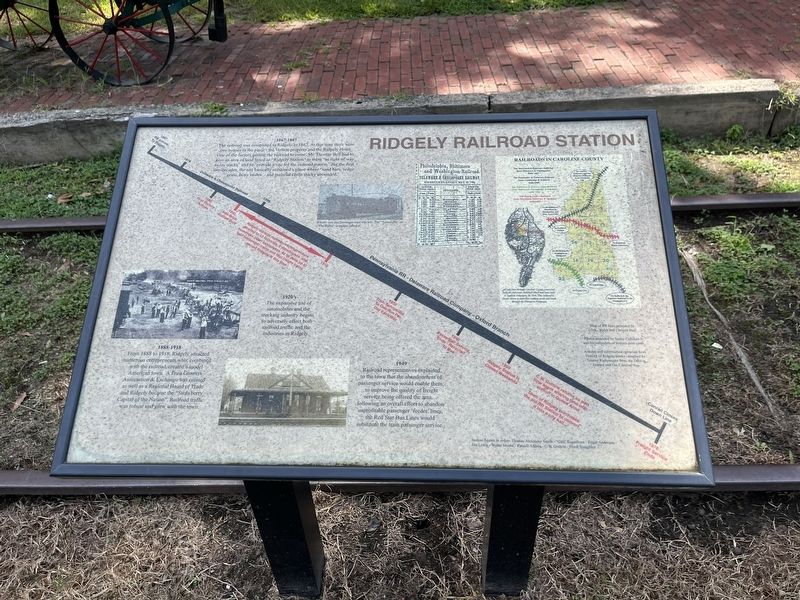
Ridgely Railroad Station
1867 - 1887
The railroad was completed to Ridgely in 1867. At that time there were two houses in the place — the Vernon property and the Ridgely Hotel. One of the factors getting the railroad to come. Mr. Thomas Bell had to give an area of land listed as "Ridgely Station" to them "as right of way to lay tracks" and to "provide a site for the railroad station." For the first two decades, the site basically remained a place a place where "sand bars, sedge grass, bony mules… and malarial chills thicky abounded."
1888 - 1918
From 1888 to 1918, Ridgely attracted numerous entrepreneurs who, combined with the railroad, created a model American town. A Fruit Growers Association & Exchange was created as well as a Regional Board of Trade and Ridgely became the "Strawberry Capital of the Nation". Railroad traffic was robust and grew with the town.
1920's
The expansive use of automobiles and the trucking industry begins to adversely effect both railroad traffic and the industries in Ridgely.
1949
Railroad representatives explained to the town that the abandonment of passenger service would enable them, to improve the quality of freight service being offered to the area… following an overall effort to abandon unprofitable passenger 'feeder' lines, the Red Star Bus Lines would substitute the train passenger service.
[Timeline:]
1867: RR comes to Ridgely
Delaware & Chesapeake Railroad
1888: First factory arrives
1892: New Brick Station Built
1892 - 1918: Ridgely attracts numerous entrepreneurs growing to 13 factories, 6 warehouses and numerous other businesses. At its peak up to four passenger trains and four freight trains served Ridgely at this time.
Pennsylvania RR - Delaware Railroad Company - Oxford Branch
1935: Train service out to one run per day each way.
1949: Passenger service ends - rerouted to bus
Conrail Closes Down Line
1976: Freight service ends.
Station Agents in order: Thomas Alexander Smith • "Gus" Koeneman • Edgar Anderson • Jim Lewis • Walter Moore • Russell Adams • C.W. Guthrie • Frank Slaughter
Railroads in Caroline County
The Maryland & Delaware Railroad (later Delaware & Chesapeake) built 1867
The Dorchester & Delaware Railroad (later Cambridge and Seaford) built 1868
The Baltimore & Eastern
The Queen Anne's Railroad (later Maryland, Delaware & Virginia) built 1896.
All rail lines through Caroline County connected with the Delaware Railroad which had been built to Seaford, Delaware, by 1856. This railroad is shown above in dark blue running north and south through the Delmarva Peninsula.
Topics and series. This historical marker is listed in these topic lists: Agriculture • Industry & Commerce • Railroads & Streetcars • Roads & Vehicles. In addition, it is included in the Pennsylvania Railroad (PRR) series list. A significant historical year for this entry is 1867.
Location. 38° 56.836′ N, 75° 53.151′ W. Marker is in Ridgely, Maryland, in Caroline County. Marker is at the intersection of West Belle Street and North Maryland Avenue, on the right when traveling west on West Belle Street. Touch for map. Marker is at or near this postal address: 2 N Maryland Ave, Ridgely MD 21660, United States of America. Touch for directions.
Other nearby markers. At least 8 other markers are within 4 miles of this marker, measured as the crow flies. Ridgely Memorial Park (within shouting distance of this marker); The Drinking Fountain (about 300 feet away, measured in a direct line); Saulsbury House - Fifer Hospital - Ridgely House (about 500 feet away); Town of Ridgely Flag (about 600 feet away); Ridgely, MD 1888 - 1917 (approx. 0.2 miles away); Adkins Arboretum (approx. 2.6 miles away); Wood Ducks (approx. 2.6 miles away); St. Paul’s Episcopal Church (approx. 3.7 miles away). Touch for a list and map of all markers in Ridgely.
Credits. This page was last revised on September 5, 2022. It was originally submitted on September 5, 2022, by Devry Becker Jones of Washington, District of Columbia. This page has been viewed 129 times since then and 23 times this year. Photos: 1, 2. submitted on September 5, 2022, by Devry Becker Jones of Washington, District of Columbia.

