Fort Loramie in Shelby County, Ohio — The American Midwest (Great Lakes)
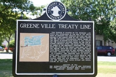
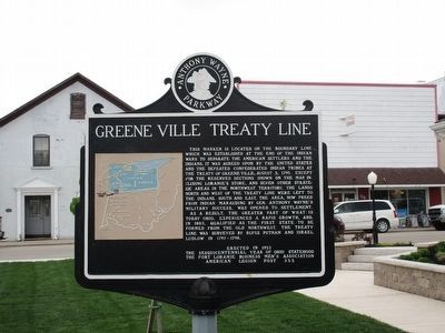
Greene Ville Treaty Line
Anthony Wayne Parkway
This marker is located on the boundary line which was established at the end of the Indian wars to separate the American settlers and the Indians. It was agreed upon by the United States and the defeated confederated Indian tribes at the Treaty of Greene Ville. August 3, 1795. Except for the reserved sections shown on the map, including Loramie's Store, and seven other strategic areas in the Northwest Territory. The lands north and west of the treaty line were left to the Indians. South and east, the area, now freed from Indians marauding by Ge. Anthony Wayne's military success, was opened to settlement.
As a result, the greater part of what is today Ohio, experienced a rapid growth, and, in 1803, qualified as the first state to be formed from the Old Northwest. The treaty line was surveyed by Rufus Putnam and Israel Ludlow in 1797-1798.
Erected 1953 by The Sesquicentennial Year of Ohio Statehood, The Fort Loramie Business Men's Association, and the American Legion Post 355.
Topics. This historical marker is listed in these topic lists: Native Americans • Peace • Wars, US Indian. A significant historical year for this entry is 1795.
Location. 40° 21.056′ N, 84° 22.5′ W. Marker is in Fort Loramie, Ohio, in Shelby County. Marker is at the intersection of West Main Street and Water Street, on the left when traveling south on West Main Street. This historical marker is located in the middle of a park that is situated along State Route 66, in the north end of Fort Loramie, Ohio. Touch for map. Marker is in this post office area: Fort Loramie OH 45845, United States of America. Touch for directions.
Other nearby markers. At least 8 other markers are within 3 miles of this marker, measured as the crow flies. Miami and Erie Canal (here, next to this marker); Miami Erie Canal Mile Stone (here, next to this marker); Fort Loramie Veterans Monument (a few steps from this marker); Pioneer Portage (about 300 feet away, measured in a direct line); Veterans Memorial (approx. 0.2 miles away); Greenville Treaty Line (approx. half a mile away); Fort Loramie (approx. 0.7 miles away); Minster (approx. 2.2 miles away). Touch for a list and map of all markers in Fort Loramie.
Also see . . .
1. Treaty of Greeneville (1795). This link is published and made available by, "Ohio History Central," an online encyclopedia of Ohio History. (Submitted on July 6, 2009, by Dale K. Benington of Toledo, Ohio.)
2. Fort Loramie. This link is published and made available by, "Ohio History Central," an online encyclopedia of Ohio History. (Submitted on July 6, 2009, by Dale K. Benington of Toledo, Ohio.)
3. Treaty of Greenville. This web link was both published and made available by, "Absolute Astronomy.com," in it's quest to enable "exploring
the universe of knowledge." (Submitted on July 6, 2009, by Dale K. Benington of Toledo, Ohio.)
4. Treaty of Greene Ville. This web link was both published and made available by, "Touring Ohio." (Submitted on July 6, 2009, by Dale K. Benington of Toledo, Ohio.)
Credits. This page was last revised on July 16, 2022. It was originally submitted on July 6, 2009, by Dale K. Benington of Toledo, Ohio. This page has been viewed 1,558 times since then and 23 times this year. Photos: 1, 2, 3. submitted on July 6, 2009, by Dale K. Benington of Toledo, Ohio. 4. submitted on May 3, 2016, by Rev. Ronald Irick of West Liberty, Ohio. • Craig Swain was the editor who published this page.


