
Tepoztlán, Morelos, Mexico — The Central Highlands (North America)
First City Council of Tepoztlán

Photographed by J. Makali Bruton, August 6, 2022
1. First City Council of Tepotzlán Marker

En 1820, el 8 de septiembre, día en que se festejaba a Tepuztecatl, el pueblo de Tepoztlan instala su primer ayuntamiento.
En 1826 se ratifica el ayuntamiento de Tepoztlán, enmarcado en el Estado de México.
H. Cabildo de Tepoztlan
C.Rogelio Torres Ortega Presidente Municipal de Tepoztlan 2019-2021
Gobierno del Estado de Morelos
C. Cuauhtemoc Blanco Bravo Gobernador del Estado de Morelos 2018-2024
8 de septiembre 2020
200 Years since the Installation of the First City Council of Tepoztlán, Morelos. (1820-2020)
In 1820, on September 8, the day on which Tepuztecatl was celebrated, the town of Tepoztlan installed its first town hall.
In 1826 the municipality of Tepoztlán, as part of the State of Mexico, was ratified.
Honorable City Council of Tepoztlan
Rogelio Torres Ortega, Municipal President of Tepoztlan 2019-2021
Government of the State of Morelos
Cuauhtemoc Blanco Bravo, Governor of the State of Morelos 2018-2024
September 8, 2020
Erected 2020.
Topics. This historical marker is listed in these topic
this page online
Location. 18° 59.186′ N, 99° 6.074′ W. Marker is in Tepoztlán, Morelos. It can be reached from 5 de Mayo just south of Avenida Ignacio Zaragoza, on the left when traveling south. Touch for map. Marker is at or near this postal address: 5 de Mayo 119, Tepoztlán MOR 62520, Mexico. Touch for directions.

Regionally, this marker is in Central Mexico. Globally, it is in North America, specifically in Mesoamerica, on the Ring of Fire, and in the Western Hemisphere. Historically, it finds itself in what was once New Spain, a Spanish colony, and the Aztec Empire.
Other nearby markers. At least 8 other markers are within 16 kilometers of this marker, measured as the crow flies: El Tepozteco National Park (within shouting distance of this marker); Coyulan (Lugar de Coyotes) (approx. 0.6 kilometers away); Temple of Tezcatlipoca (approx. 14.1 kilometers away); Teopanzolco (approx. 14.1 kilometers away); Temples of Tlaloc and Huitilopochtli (approx. 14.2 kilometers away); The Temple of Ehécatl (approx. 14.2 kilometers away); Minor Temples (approx. 14.2

Photographed by J. Makali Bruton, August 6, 2022
2. Additional tablets near the First City Council of Tepotzlán Marker
These additional tablets include a commemoration of the City Council of 1995-1997 and a tribute to local environmentalist Marcos Olmedo Gutiérrez.

Photographed by J. Makali Bruton, August 6, 2022
3. First City Council of Tepotzlán Marker
Photographed by J. Makali Bruton, August 6, 2022
4. First City Council of Tepotzlán Marker
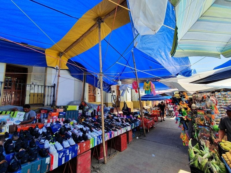
It can be hard to see the marker as the Ayuntamiento of Tepotzlán is often blocked by vendors.
Credits. This page was last revised on February 18, 2024. It was originally submitted on October 5, 2022, by J. Makali Bruton of Washington, District of Columbia. This page has been viewed 210 times since then and 23 times this year. Photos: 1, 2, 3, 4. submitted on October 5, 2022, by J. Makali Bruton of Washington, District of Columbia.
