Pasadena in Anne Arundel County, Maryland — The American Northeast (Mid-Atlantic)
The Chesapeake Bay
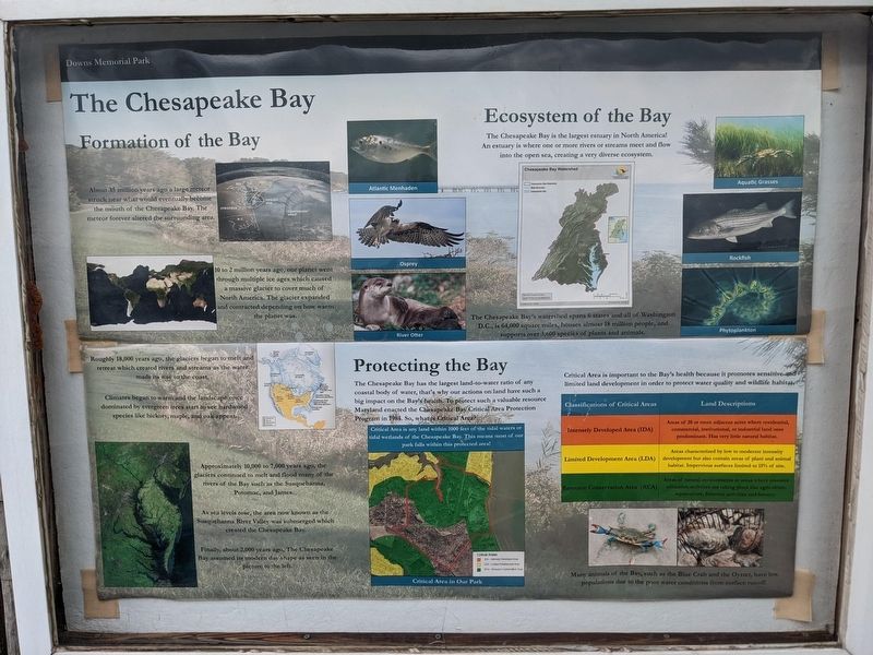
About 35 million years ago a large meteor struck near what would eventually become the mouth of the Chesapeake Bay. The meteor forever altered the surrounding area.
10 to 2 million years ago, our planet went through multiple ice ages which caused a massive glacier to cover much of North America. The glacier expanded and contracted depending on how warm the planet was.
Roughly 18,000 years ago, the glaciers began to melt and retreat which created rivers and streams as the water made its way to the coast.
Climates began to warm and the landscape once dominated ever evergreen trees start to see hardwood species like hickory, maple, and oak appear.
Approximately 10,000 to 7,000 years ago, the glaciers continue to melt and flood many of the rivers of the Bay such as the Susquehanna, Potomac, and James.
As sea levels rose, the area now known as the Susquehanna River Valley was submerged which created the Chesapeake Bay.
Finally, about 2,000 years ago, The Chesapeake Bay assumed its modern day shape as seen in the picture to the left.
Ecosystem of the Bay
The Chesapeake Bay is the largest estuary in North America! An estuary is where one or more rivers or streams meet and flow into the open sea, creating a very diverse ecosystem.
The Chesapeake Bay's watershed spans 6 states and all of Washington, D.C., is 64,000 square miles, houses almost 18 million people, and supports over 3,600 species of plants and animals.
Protecting the Bay
The Chesapeake Bay has the largest land-to-water ratio of any coastal body of water, that's why our actions on land have such a big impact on the Bay's health. To protect such a valuable resource Maryland enacted the Chesapeake Bay Critical Area Protection Program in 1984. So, what is a Critical Area?
Critical Area is any land within 1000 feet of the tidal waters or tidal wetlands of the Chesapeake Bay. This means most of our park falls within this protected area!
Critical Area is important to the Bay's health because it promotes sensitive and limited land development in order to protect water quality and wildlife habitat.
Classifications of Critical Areas: Land Descriptions
Intensely Developed Area (IDA): Areas of 20 or more adjacent acres where residential, commercial, institutional, or industrial land uses predominate. Has very little natural habitat.
Limited Development Area (LDA): Areas characterized by low to moderate intensity development but also contain areas of plant and animal habitat. Impervious surfaces limited to 15% of site.
Resource Conservation Area (RCA): Areas of natural environments or areas where resource utilization activities are taking place like agriculture, aquaculture, fisheries activities and forestry.
Erected by Downs Memorial Park.
Topics. This historical marker is listed in these topic lists: Environment • Parks & Recreational Areas • Waterways & Vessels.
Location. 39° 6.596′ N, 76° 25.992′ W. Marker is in Pasadena, Maryland, in Anne Arundel County. Marker is on John Downs Loop. Touch for map. Marker is in this post office area: Pasadena MD 21122, United States of America. Touch for directions.
Other nearby markers. At least 8 other markers are within walking distance of this marker. The Rocky Beach Oyster Farm (a few steps from this marker); Summer House on the Bay (within shouting distance of this marker); The old entrance road (about 300 feet away, measured in a direct line); The Wishing Bench (about 300 feet away); Garden Gazebo (about 400 feet away); Mother's Garden (about 400 feet away); Improvements on the Bayfront (about 600 feet away); Kids on the Farm (approx. 0.2 miles away). Touch for a list and map of all markers in Pasadena.
More about this marker. The marker shows a variety of pictures. Along the left, under "Formation of the Bay," are various maps of the Chesapeake Bay and North America through geologic time.
On the upper right, under "Ecosystem of the Bay," are images of the following: Atlantic Menhaden, Osprey, River Otter, Aquatic Grasses, Rockfish, and Phytoplankton.
On the lower right, under "Protecting the Bay," is a map of the Critical Area in Downs Memorial Park and a photo of a club grab and oyster shells with the caption: Many animals of the Bay, such as the Blue Crab and the Oyster, have low populations due to the poor water conditions from surface runoff.
Credits. This page was last revised on November 4, 2022. It was originally submitted on November 2, 2022, by Sean C Bath of Silver Spring, Maryland. This page has been viewed 97 times since then and 19 times this year. Photo 1. submitted on November 2, 2022, by Sean C Bath of Silver Spring, Maryland. • Bill Pfingsten was the editor who published this page.
