Manahawkin in Stafford Township in Ocean County, New Jersey — The American Northeast (Mid-Atlantic)
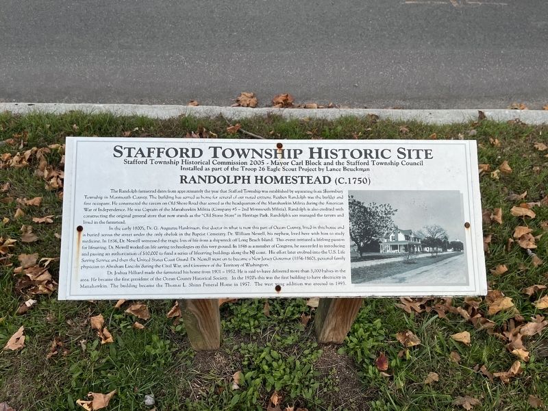
Randolph Homestead (C. 1750)
Stafford Township Historic Site
The Randolph farmstead dates from approximately the year that Stafford Township was established by separating from Shrewsbury Township in Monmouth County. The building has served as home for several of our noted citizens. Reuben Randolph was the builder and first occupant. He constructed the tavern on Old Shore Road that served as the headquarters of the Manahawkin Militia during the American War of Independence. He was Captain of the Manahawkin Militia (Company #5 - 2nd Monmouth Militia). Randolph is also credited with constructing the original general store that now stands as the "Old Stone Store" in Heritage Park. Randolph's son managed the tavern and lived in the farmstead.
In the early 1800's, Dr. G. Augustus Hankinson, first doctor in what is now this part of Ocean County, lived in this house and is buried across the street under the only obelisk in Baptist Cemetery. Dr. William Newell, his nephew, lived here with him to study medicine. In 1836, Dr. Newell witnessed the tragic loss of life from a shipwreck off Long Beach Island. This event initiated a lifelong passion for lifesaving. Dr. Newell worked on life saving technologies on this very ground. In 1848 as a member of Congress, he succeeded in introducing and passing an authorization of $10,000 to fund a series of lifesaving buildings along the NJ coast. His effort later evolved into the U.S. Life Saving Service and then the United States Coast Guard. Dr. Newell went on to become a New Jersey Governor (1856-1860), personal family physician to Abraham Lincoln during the Civil War, and Governor of the Territory of Washington.
Dr. Joshua Hilliard made the farmstead his home from 1901 - 1952. He is said to have delivered more than 3,000 babies in the area. He became the first president of the Ocean County Historical Society. In the 1920's this was the first building to have electricity in Manahawkin. The building became the Thomas L. Shinn Funeral Home in 1957. The west wing addition was erected in 1993.
Erected 2005 by Stafford Township Historical Commission, Mayor Carl Block and Stafford Township Council; installed as part of the Troop 26 Eagle Scout Project by Lance Beuckman.
Topics. This historical marker is listed in these topic lists: Government & Politics • Industry & Commerce • Political Subdivisions • Science & Medicine • War, US Civil • War, US Revolutionary. A significant historical year for this entry is 1836.
Location. 39° 41.875′ N, 74° 15.465′ W. Marker is in Stafford Township, New Jersey, in Ocean County. It is in Manahawkin. Marker is at the intersection of North Main Street (U.S. 9)
Other nearby markers. At least 8 other markers are within walking distance of this marker. Roger "Doc" Cramer 1905-1990 (here, next to this marker); Manahawkin Skirmish (within shouting distance of this marker); Old Manahawkin Baptist Church (C. 1758) (within shouting distance of this marker); Henry Remsen Hankeinson (about 300 feet away, measured in a direct line); Reuben Randolph Manahawkin Tavern, C 1750-1905 (about 400 feet away); National Hotel C. 1830 (about 700 feet away); Hall Store (1885) (about 700 feet away); World Trade Center Artifact (approx. 0.2 miles away). Touch for a list and map of all markers in Stafford Township.
Credits. This page was last revised on February 7, 2023. It was originally submitted on November 3, 2022, by Devry Becker Jones of Washington, District of Columbia. This page has been viewed 103 times since then and 10 times this year. Photos: 1, 2. submitted on November 3, 2022, by Devry Becker Jones of Washington, District of Columbia.

