Damascus in Washington County, Virginia — The American South (Mid-Atlantic)
Legion Island
—
The Damascus History Tour
—
Photographed by Cosmos Mariner, October 6, 2022
1. Legion Island Marker
Inscription.
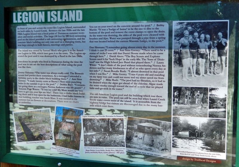
Legion Island. . , In front of you and across the water lies Legion Island, surrounded on both sides by Laurel Creek. Between the late 1920s and the late 1960s Legion Island was a focal point of Damascus summer recreation and social activities. The large (40 feet by 100 feet) swimming pool on the island provided a safe swimming environment, and the concrete block building not only was used as a changing room, but was large enough to hold dances, meetings and parties. , The island was owned by Samuel Mock who gave it to the American Legion in 1926, which later gave it to the town. The Legion operated the pool until it was destroyed by a flood in the late 1960s., Anecdotes by people who lived in Damascus during the time the pool was in use are the best descriptions of what using the pool was like then., Jimmy Osborne: "The water was always really cold. The Brownie scouts had parties there sometimes. As a teenager I attended a birthday party in the cinder block building there." / Ann Sims Gorney: "I made twenty cents at Shorty's Shoe store punching holes in the sandals to go to the pool." / Debbie Barr: "I remember going there as a teenager, Norma Anderson was life guard." / Tommie Pratt Waters: "It was icy cold! My Mom would say 'you have to get out, your lips are blue'. There was a cinder block building there and it was open for the bathroom. I had ballet lessons in that building, teacher was Sarah Mast. It was mowed in the summer but no flowers or decorations. There were no chairs or umbrellas. You sat on your towel on the concrete around the pool." / Bobby Martin: "It was a 'badge of honor' to be the one to dive to the bottom of the pool and remove the cover clamps to open the drain. As the water was draining, the sides of the pool were cleaned with brushes and Ajax. Water was pumped through a pipe from a spring that was located behind the current Masonic Lodge, to the pool." , Dan Shumate: "I remember going almost every day in the summer. I think it cost 25 cents." / Ann Sims Gorney: "There used to be a statue of rocks I was told that Daniel Boone made when he came through here." / David Akers: "The Boy Scouts and Explorer Scouts used it for 'Sock Hops' in the early 60s. The 'Sons of Dixieland' was the High School Jazz Band that played there." / Laura White: "I don't think of the pool without remembering Norma Anderson and her many kindnesses to all of us who spent every day at her side." / Susan Rosalie Rush: "I almost drowned in that pool when I was five." / Mike Gentry "I was 4 years old and standing on my tippy toes and could not move and my sister saved me from drowning!" / Mike Rush: "The pool had no filtration, so it had to be drained when the algae got ahead of the chlorine. Algae made the water murky enough toward the end of a cycle that we played hide-and-go-seek in the water." , The old American Legion pool and the building which was there are now in ruins. The pool can still be seen but when Laurel Creek floods water covers most of the island. It is accessible from the highway bridge but visitors are discouraged due to the many hazards which exist there.
In front of you and across the water lies Legion Island, surrounded on both sides by Laurel Creek. Between the late 1920s and the late 1960s Legion Island was a focal point of Damascus summer recreation and social activities. The large (40 feet by 100 feet) swimming pool on the island provided a safe swimming environment, and the concrete block building not only was used as a changing room, but was large enough to hold dances, meetings and parties.
The island was owned by Samuel Mock who gave it to the American Legion in 1926, which later gave it to the town. The Legion operated the pool until it was destroyed by a flood in the late 1960s.
Anecdotes by people who lived in Damascus during the time the pool was in use are the best descriptions of what using the pool was like then.
Jimmy Osborne: "The water was always really cold. The Brownie scouts had parties there sometimes. As a teenager I attended a birthday party in the cinder block building there." / Ann Sims Gorney: "I made twenty cents at Shorty's Shoe store punching holes in the sandals to go to the pool." / Debbie Barr: "I remember going there as a teenager, Norma
Click or scan to see this page online
Anderson was life guard." / Tommie Pratt Waters: "It was icy cold! My Mom would say 'you have to get out, your lips are blue'. There was a cinder block building there and it was open for the bathroom. I had ballet lessons in that building, teacher was Sarah Mast. It was mowed in the summer but no flowers or decorations. There were no chairs or umbrellas. You sat on your towel on the concrete around the pool." / Bobby Martin: "It was a 'badge of honor' to be the one to dive to the bottom of the pool and remove the cover clamps to open the drain. As the water was draining, the sides of the pool were cleaned with brushes and Ajax. Water was pumped through a pipe from a spring that was located behind the current Masonic Lodge, to the pool."
Dan Shumate: "I remember going almost every day in the summer. I think it cost 25 cents." / Ann Sims Gorney: "There used to be a statue of rocks I was told that Daniel Boone made when he came through here." / David Akers: "The Boy Scouts and Explorer Scouts used it for 'Sock Hops' in the early 60s. The 'Sons of Dixieland' was the High School Jazz Band that played there." / Laura White: "I don't think
2. Marker detail: The Swimming Pool in 2020
of the pool without remembering Norma Anderson and her many kindnesses to all of us who spent every day at her side." / Susan Rosalie Rush: "I almost drowned in that pool when I was five." / Mike Gentry "I was 4 years old and standing on my tippy toes and could not move and my sister saved me from drowning!" / Mike Rush: "The pool had no filtration, so it had to be drained when the algae got ahead of the chlorine. Algae made the water murky enough toward the end of a cycle that we played hide-and-go-seek in the water."
The old American Legion pool and the building which was there are now in ruins. The pool can still be seen but when Laurel Creek floods water covers most of the island. It is accessible from the highway bridge but visitors are discouraged due to the many hazards which exist there.
Location. 36° 38.057′ N, 81° 47.152′ W. Marker is in Damascus,
3. Marker detail: Remains of the fireplace and chimney in the American Legion Post
Virginia, in Washington County. It is on East Laurel Avenue (U.S. 58) just east of Trestle Street, on the left when traveling east. Marker is located beside the walkway on the north side of the bridge, overlooking Laurel Creek and Legion Island. Touch for map. Marker is in this post office area: Damascus VA 24236, United States of America. Touch for directions.
Regionally, this marker is in Virginia’s Tri-Cities Area, in Southwest Virginia, and in the Blue Ridge Highlands. It is also in the American South, specifically in the Upper South, in Appalachia, and specifically in Southern Appalachia. Globally, it is in North America, the Western Hemisphere, the Western World, and the Anglosphere. Historically, it finds itself in what was once the territory of the Mississippian Culture, one of the original Thirteen Colonies, one of the Confederate States of America, and the Antebellum South.
Regarding Legion Island. The swimming pool ruins on Legion Island are clearly visible in the satellite view - except when obscured by foliage.
Related markers. Click here for a list of markers that are related to this marker. The Damascus History Tour
5. Marker detail: American Legion Post Surrounded, January 1957
from E.F. and Vinny Smith family album
6. Marker detail: Unidentified Damascans in photos from the mid-1920s
Photographed by Cosmos Mariner, October 6, 2022
7. Legion Island Marker
(looking north • Laurel Creek and Legion Island in background)
Photographed by Cosmos Mariner, October 6, 2022
8. Legion Island
(looking north from near marker • swimming pool ruins are obscured by foliage)
Credits. This page was last revised on February 2, 2023. It was originally submitted on November 5, 2022, by Cosmos Mariner of Cape Canaveral, Florida. This page has been viewed 840 times since then and 60 times this year. Photos:1, 2, 3, 4, 5, 6, 7, 8. submitted on November 6, 2022, by Cosmos Mariner of Cape Canaveral, Florida.