Fort Wayne in Allen County, Indiana — The American Midwest (Great Lakes)
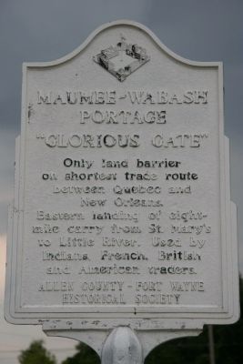
Maumee - Wabash Portage
"Glorious Gate"
Erected by Allen County - Fort Wayne Historical Society.
Topics. This historical marker is listed in these topic lists: Colonial Era • Industry & Commerce • Landmarks • Native Americans.
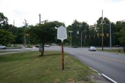
Location. 41° 4.462′ N, 85° 10.795′ W. Marker is in Fort Wayne, Indiana, in Allen County. Marker is on Lindenwood Avenue, 0 miles north of West Jefferson Boulevard, on the right when traveling north. Touch for map. Marker is in this post office area: Fort Wayne IN 46802, United States of America. Touch for directions.
Other nearby markers. At least 8 other markers are within 2 miles of this marker, measured as the crow flies. Lindenwood Cemetery (approx. half a mile away); Wabash and Erie Canal Groundbreaking (approx. 0.8 miles away); Camp Allen 1861-64 (approx. 1.1 miles away); Site of the Fort Wayne College (approx. 1.2 miles away); "Johnny Appleseed" (approx. 1.2 miles away); Carole Lombard (approx. 1.4 miles away); Old Aqueduct Club Memorial (approx. 1.4 miles away); The First French Fort / The First Playground in Fort Wayne (approx. 1.6 miles away). Touch for a list and map of all markers in Fort Wayne.
More about this marker. Years ago I attempted to locate some kind of marker that would be devoted to commemorating and locating the original site of the "Glorious Gate," a.k.a. the Wabash - Maumee Portage. I couldn't find one back then, and I had difficulty finding this one now. What made this marker difficult to locate was that I truly expected to find the marker for this particular historical site much closer to the spot where the actual portage made contact with the St. Mary's River. As it is, this historical marker is 0.9 miles (as the crow flies) west of the St. Mary's River, but it is situated along the pathway of the portage. If you cross the St. Mary's River on the West Jefferson Boleuvard, continue to travel west on this Boleuvard for about one mile and right after you go under the railroad viaduct, look to your right at the first intersection beyond the viaduct and you should see this historical marker.
Also see . . . Wikipedia entry for Kekionga. (Submitted on July 24, 2009, by Dale K. Benington of Toledo, Ohio.)
Credits. This page was last revised on August 5, 2021. It was originally submitted on July 24, 2009, by Dale K. Benington of Toledo, Ohio. This page has been viewed 3,424 times since then and 119 times this year. Photos: 1, 2. submitted on July 24, 2009, by Dale K. Benington of Toledo, Ohio. • Kevin W. was the editor who published this page.

