Devil's Pocket in Philadelphia in Philadelphia County, Pennsylvania — The American Northeast (Mid-Atlantic)
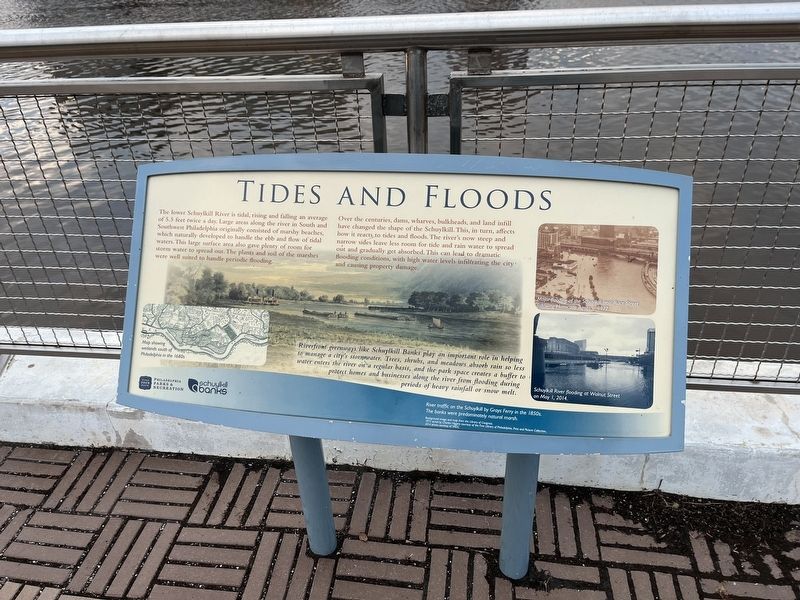
Tides and Floods
The lower Schuylkill River is tidal, rising and falling an average of 5.5 feet twice a day. Large areas along the river in South and Southwest Philadelphia originally consisted of marshy beaches, which naturally developed to handle the ebb and flow of tidal waters. This large surface area also gave plenty of room for storm water to spread out. The plants and soil of the marshes were well suited to handle periodic flooding.
Over the centuries, dams, wharves, bulkheads, and land infill have changed the shape of the Schuylkill. This, in turn, affects how it reacts to tides and floods. The river's now steep and narrow sides leave less room for tide and rain water to spread out and gradually get absorbed. This can lead to dramatic flooding conditions, with high water levels infiltrating the city and causing property damage.
Riverfront greenways like Schuylkill Banks play an important role in helping to manage a city's stormwater. Trees, shrubs, and meadows absorb rain so less water enters the river on a regular basis, and the park space creates a buffer to protect homes and businesses along the river from flooding during periods of heavy rainfall or snow melt.
[Captions:]
Map showing wetlands south of Philadelphia in the 1680s.
Major flooding of the Schuylkill near Race Street following Hurricane Agnes in 1972.
Schuylkill River flooding at Walnut Street on May 1, 2014.
River traffic on the Schuylkill River by Grays Ferry in the 1850s. The banks were predominately natural marsh.
Erected by Philadelphia Parks & Recreation; Schuylkill Banks.
Topics. This historical marker is listed in these topic lists: Disasters • Environment • Parks & Recreational Areas • Waterways & Vessels. A significant historical date for this entry is May 1, 2014.
Location. 39° 56.733′ N, 75° 11.278′ W. Marker is in Philadelphia, Pennsylvania, in Philadelphia County. It is in Devil's Pocket. Marker is on Schuylkill River Trail south of South Street, on the right when traveling south. Touch for map. Marker is at or near this postal address: 624 Schuylkill Ave, Philadelphia PA 19146, United States of America. Touch for directions.
Other nearby markers. At least 8 other markers are within walking distance of this marker. A force of nature and commerce (about 400 feet away, measured in a direct line); The arteries of industry (about 400 feet away); Workshop of the world (about 400 feet away); South Street Bridge (about 600 feet away); Pioneering Pediatrics (about 700 feet away); These 19th-century Belgian blocks… (about 700 feet away); Generating Energy (approx. 0.2 miles away); To Henry Laussat Geyelin (approx. ¼ mile away). Touch for a list and map of all markers in Philadelphia.
Credits. This page was last revised on February 2, 2023. It was originally submitted on December 22, 2022, by Devry Becker Jones of Washington, District of Columbia. This page has been viewed 61 times since then and 16 times this year. Photos: 1, 2. submitted on December 22, 2022, by Devry Becker Jones of Washington, District of Columbia.

