Dyer in Lake County, Indiana — The American Midwest (Great Lakes)
The Lincoln Highway
Ideal Section & Monument
Ideal Section
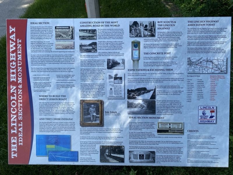
During the first few years of its existence, the Lincoln Highway Association (LHA) worked feverishly to promote the idea of a transcontinental highway. The excitement and enthusiasm of Americans for better roads became well established. Also, early legislation by the federal government for funding road building was taking root.
With these happenings, the Lincoln Highway Association chose to concentrate on the development of standards for road-building. By 1920, the LHA proposed an "Ideal Section" as an "Object Lesson" in road construction that would be the embodiment of the most technologically advanced engineering and construction.
On June 5, 1920, the Lincoln Highway Association placed an article in Collier's Magazine asking people send their thoughts and ideas for the "perfect road" giving every reader an opportunity to have a say. In September of 1920, the LHA mailed out over 4,600 questionnaires to highway engineers, professors of highway engineering, state highway commissioners and leading experts across the country. They received responses from 33 states representing a wide variety of techniques, current practices, and ideas.
The LHA Board of Directors appointed seventeen highway experts and engineers who met between December 1920 and February of 1921 to review the data submitted. They determined the best specifications for this futuristic highway:
a right-of-way of 110 feet in width;
a steel reinforced concrete road bed 40 feet wide and 10 inches thick to accommodate four lanes of traffic;
to support loads of 16,000 pounds per axle and capable of handling up to 15,000 automobiles per day traveling at 35 mph and 5,000 motor trucks per day traveling at 10 mph;
a footpath for pedestrians to insure safety and aesthetic beauty;
elevated curves, special bridges, proper drainage with submerged drain tiles and catch basins, and guard rails;
roadside beautification and landscaping;
and illumination, making it the first section of highway in the United States to provide illumination for night driving.
Where to Build the Object Lesson Road?
After selecting their overall engineering firm, Lockwood, Greene & Co. of Boston, the next task for the LHA Board of Directors was to choose a location for this mile-long stretch of road. With over 3,000 miles on the Lincoln Highway, the committee narrowed the selection down to five states; New Jersey, Pennsylvania, Ohio, Indiana or Nebraska. To the credit and foresight of the Indiana State Highway Commission (precursor to INDOT), they submitted a series of resolutions to the committee making it clear
they were ready to support this project.
And They Chose Indiana!
The selection committee which also included members of the LHA Board, the engineering firm and the landscape architect, visited various sites. In April 1921, the 1.3-mile stretch between Dyer and Schererville was chosen. News of the selection spread far and wide including an article in a Japanese newspaper. Proponents for better roads, such as the Canadian Transcontinental Highway Association, watched the progress with great interest.
Construction of the Most Amazing Road in the World
The Association awarded the construction bid for the project to J.C. O'Connor & Sons of Fort Wayne. The Ideal Section was built during 1922 and 1923 with Federal, State, and county funds along with $130,000 donated by United States Rubber Company. Magazines and newspapers called the Ideal Section a "vision of the future".
Despite delays, all paving, as well as concrete work on the bridge and culvert were completed by November 1922. Grading the shoulders, masonry handrails on the bridge were done in April of 1923. And the landscaping by Jens Jenson was completed by mid-June of 1923.
After completion, highway officials and engineers came from around the world to study this road-building marvel and brought ideas back to be used in road projects in their communities and countries.
One example of how the LHA inspired others came from Valparaiso, Chile where a concrete road was being planned in 1925 to connect Lima, Peru with Valparaiso, Chile based on information learned from the Ideal Section.
Lighting equipment contributed by the General Electric Co. had been shipped to the site, and the concrete lighting poles of approved design were manufactured in Milwaukee and installed after numerous delays before the end of the year 1923. A little over a year of free electric was provided by the Northern Indiana Gas & Electric Co. from April 1924 until September 1, 1925.
The Lincoln Highway Association planned to have President Warren G. Hardin attend a dedication of the Ideal Section in the spring of 1924, including establishing a projected budget of $5,000 for the event. Those plans changed upon the president's death in August, 1923. Plans were then made to invite President Calvin Coolidge but they never materialized. The Ideal Section was never officially dedicateduntil 2016.
Jens Jensen
Born: September 13, 1860, Denmark
Died: October 1, 1951, Ellison Bay, WI
Jens Jensen, renowned Landscape Architect from Chicago, popularized the idea of native gardens in his design philosophy which became known as Prairie Style landscape architecture. He designed numerous gardens for estates and magnificent parks.
In February of 1921, the Lincoln Highway Association retained Mr. Jensen to be in charge of the final landscaping design for the Ideal Section project.
In the Spring of 1923, Jens Jensen's plans for the landscaping were implemented. This included a pathway for pedestrians which wandered attractively through hedges and trees on the south side of the road using layered stonework, open sun-spaces and native plants and materials. Designed as a safety feature for the Ideal Section, it also incorporated comfort and beauty.
(He later submitted landscaping plans for the proposed Ideal Campsite.)
Boy Scouts & The Lincoln Highway
On September 1, 1928, in an effort to keep the Lincoln Highway from getting "lost" in the new U.S. Highway numbering system, the Lincoln Highway Association coordinated a major nationwide publicity event. They officially marked and dedicated the completed Lincoln Highway to the memory of Abraham Lincoln.
At 1:00 p.m. that day, groups of Boy Scouts across America placed approximately 2,400 concrete posts at strategic points along the Lincoln Highway. (Indiana Boy Scouts placed their posts in April 1929)
The Concrete Post
In this area, there were thirteen concrete posts placed between the Post Office in Schererville and the state line in Dyer.
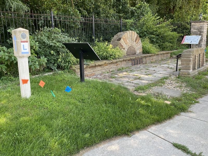
The post at this Memorial site was placed here in 2016, by Dyer Boy Scout Troop 510. It's an original post that has been repaired although its original location is unknown.
Expectations & Exceeding Them
It was estimated that the Ideal Section would last until the 1940s, at which time the condition of the road would be evaluated.
One main reason the LHA chose to build the Ideal Section here in northwest Indiana was because of its close proximity to Chicago and the amount of traffic that would travel this road dailythey really wanted to put the engineering that went into the road to the test.
These photos give some indication to the amount of traffic and the durability of the road.
Traffic JamA six to seven-mile traffic jam on the Lincoln Highway in September 1929. This photo was taken on the Ideal Section.
Famed Model Highway SectionThe road looks to be in good condition in this photo from June 1956. When U.S. 30 (Lincoln Highway) was dug up to be widened into a five-lane highway in 1997, the Rieth-Riley Construction Company found the original 10" concrete of the Ideal Section still intact under a layer of concrete from a previous resurfacing project.
Ideal Section Monument
Following the completion of the Ideal Section project in 1924, the LHA erected two temporary signboards on each end of the road to help educate the public on the purpose of the road until a permanent monument could be erected with two bronze tablets.
In 1942, the Lincoln Highway Association erected a monument to permanently mark the site of the first modern section of highway built in the United States, They chose to place two bronze tablets on a similar structure along with the H.S. Ostermann Memorial Seat.
At some point in the 1960's, the monument was damaged. The two Ideal Section plaques were placed in storage until 1969 when a new monument was erected for the two original plaques and a third one which commemorates the Sauk Indian Trail.
The third plaque was placed by The Daughters of the American Revolution (D.A.R.) in Indiana in preparation for the upcoming Bicentennial of the birth of our nation. They had chosen to mark the Indian trail, which came to be known as the Sauk Trail. (Segments of that Trail were selected in 1913 to become part of the Lincoln Highway.)
Five markers were placed from Fort Wayne to this one. The Timothy Ball D.A.R. Chapter sponsored the Sauk Trail plaque in 1969 and forty-five years later, they donated funds to restore it during the 2014-2016 restoration of this site.
The Lincoln Highway Association Today
The original Lincoln Highway Association dissolved with its final activities shortly after 1942. Eventually, as the interstate highway system and the super highways bypassed the small towns and cities, great roads like the Lincoln Highway were nearly forgotten.
However, interest in the Old Lincoln Highway was reawakened and by 1992, a reorganized Lincoln Highway Association was established with active chapters in twelve Lincoln Highway States.
Their goal is not only to preserve, promote and mark the old Lincoln Highway route across the nation, but to also educate the general public on the various related historical treasures.
The mission of the Indiana chapter of the Lincoln Highway Association (INLHA) is the same as the National. They have two routes across Indiana to promote and preserve. In 2011, both routes of the Lincoln Highway were designated as a Historic Scenic Byway.
The Original 1913 Route
Townley
Zulu
New Haven
Fort Wayne
Churubusco
Merriam
Wolf Lake
Kimmell
Ligonier
Benton
Goshen
Dunlap
Elkhart
Osceola
Mishawaka
South Bend
New Carlisle
Rolling Prairie
La Porte
Westville
Valparaiso
Deep River
Merriville
Shererville
Dyer
Rerouted in 1928 between Fort Wayne and Valparaiso:
Columbia City
Warsaw
Atwood
Etna Green
Bourbon
Inwood
Plymouth
Donaldson
Grovertown
Hamlet
Hanna
Wanatah
Topics and series. This historical marker is listed in these topic lists: Architecture • Fraternal or Sororal Organizations • Native Americans • Roads & Vehicles. In addition, it is included in the Jens Jensen, and the Lincoln Highway series lists. A significant historical month for this entry is February 1921.
Location. 41° 29.486′ N, 87° 29.845′ W. Marker is in Dyer, Indiana, in Lake County. Marker is on Joliet Street (U.S. 30) west of Northwinds Drive, on the right when traveling east. Touch for map. Marker is at or near this postal address: 1250 Joliet St, Dyer IN 46311, United States of America. Touch for directions.
Other nearby markers. At least 8 other markers are within 3 miles of this marker, measured as the crow flies. The Ideal Section Of The Lincoln Highway (here, next to this marker); Sauk (Sak) Trail (here, next to this marker); St. John Township School District #2 (approx. half a mile away); The Lincoln Highway / The "Ideal Section" (approx. 0.6 miles away); a different marker also named The Lincoln Highway / The "Ideal Section" (approx. 0.8 miles away); Lincoln Highway - Ideal Section - 1923 (approx. 0.9 miles away); a different marker also named The Lincoln Highway (approx. 1½ miles away); Sauk Village (approx. 3 miles away in Illinois). Touch for a list and map of all markers in Dyer.
Credits. This page was last revised on December 29, 2022. It was originally submitted on December 29, 2022, by Lou Donkle of Valparaiso, Indiana. This page has been viewed 176 times since then and 38 times this year. Photos: 1, 2. submitted on August 28, 2022, by Lou Donkle of Valparaiso, Indiana. • Devry Becker Jones was the editor who published this page.

