Shakopee in Scott County, Minnesota — The American Midwest (Upper Plains)
Who Else Was Here
Pathways of Shakopee History
— A self-guided tour on the development of the City of Shakopee —
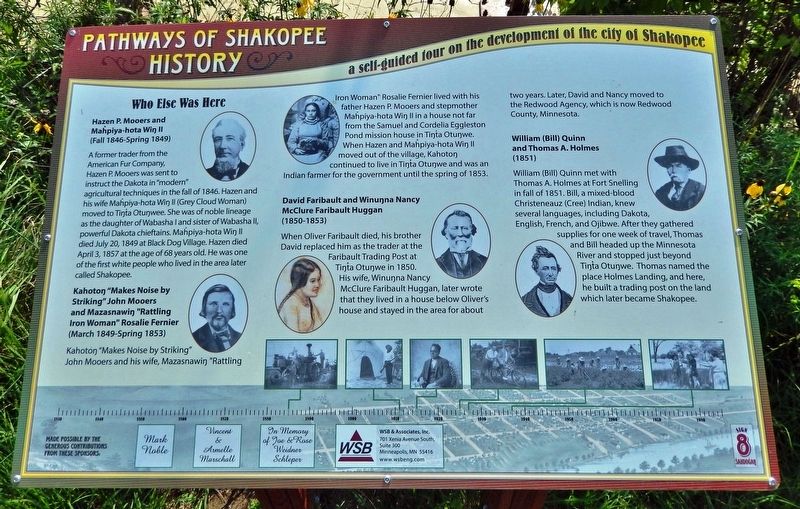
Hazen P. Mooers and Mahpiya-hota Wiŋ II
(Fall 1846 — Spring 1849)
A former trader from the American Fur Company, Hazen P. Mooers was sent to instruct the Dakota in "modern" agricultural techniques in the fall of 1846. Hazen and his wife Mahpiya-hota Wiŋ II (Grey Cloud Woman) moved to Tíŋta Otuŋwe. She was of noble lineage as the daughter of Wabasha I and sister of Wabasha II, powerful Dakota chieftains. Mahpiya-hota Wiŋ II died July 20, 1849 at Black Dog Village. Hazen died April 3, 1857 at the age of 68 years old. He was one of the first white people who lived in the area later called Shakopee.
Kahotoŋ "Makes Noise by Striking" John Mooers and Mazasnawiŋ "Rattling Iron Woman" Rosalie Fernier
(March 1849 — Spring 1853)
Kahotoŋ "Makes Noise by Striking" John Mooers and his wife, Mazasnawiŋ "Rattling Iron Woman" Rosalie Fernier lived with his father Hazen P. Mooers and stepmother Mahpiya-hota Wiŋ II in a house not far from the Samuel and Cordelia Eggleston Pond mission house in Tíŋta Otuŋwe. When Hazen and Mahpiya-hota Wiŋ II moved out of the village, Kahotoŋ continued to live in Tíŋta Otuŋwe and was an Indian farmer for the government until the spring of 1853.
David Faribault and Winuŋna Nancy McClure Faribault Huggan
(1850-1853)
When Oliver Faribault died, his brother David replaced him as the trader at the Faribault Trading Post at Tíŋta Otuŋwe in 1850. His wife, Winuŋna Nancy McClure Faribault Huggan, later wrote that they lived in a house below Oliver's house and stayed in the area for about two years. Later, David and Nancy moved to the Redwood Agency, which is now Redwood County, Minnesota.
William (Bill) Quinn and Thomas A. Holmes
(1851)
William (Bill) Quinn met with Thomas A. Holmes at Fort Snelling in fall of 1851. Bill, a mixed-blood Christeneauz (Cree) Indian, knew several languages, including Dakota, English, French, and Ojibwe. After they gathered supplies for one week of travel, Thomas and Bill headed up the Minnesota River and stopped just beyond Tíŋta Otuŋwe. Thomas named the place Holmes Landing, and here, he built a trading post on the land which later became Shakopee.
Erected by Pathways of Shakopee History; and WSB & Associates, Inc. (Marker Number 8.)
Topics. This historical marker is listed in these topic lists: Agriculture • Industry & Commerce • Native Americans • Settlements & Settlers. A significant historical year for this entry is 1846.
Location. 44° 48.055′ N, 93° 30.279′ W. Marker
is in Shakopee, Minnesota, in Scott County. Marker can be reached from the intersection of County Road 101 (Business U.S. 169) and Sarazin Street, on the right when traveling west. Marker is located along the Pathways of Shakopee History Trail, which begins near the west end of Memorial Park. This marker is on the south side of the Highway 101 bridge. Touch for map. Marker is at or near this postal address: 1801 County Road 101, Shakopee MN 55379, United States of America. Touch for directions.
Other nearby markers. At least 8 other markers are within walking distance of this marker. The Springs (a few steps from this marker); The Ox Cart Trail to Shakopee (a few steps from this marker); Stagecoaches to Shakopee (within shouting distance of this marker); The Railroad to Shakopee 1865 (within shouting distance of this marker); Pond Mission (within shouting distance of this marker); Betting, Booze & Speakeasies • 1920-1940 (within shouting distance of this marker); On The River Bottoms (within shouting distance of this marker); Rollin' Down the River 1842 (about 300 feet away, measured in a direct line). Touch for a list and map of all markers in Shakopee.
Related markers. Click here for a list of markers that are related to this marker. Pathways of Shakopee History Trail
Credits. This page was last revised on December 31, 2022. It was originally submitted on December 30, 2022, by Cosmos Mariner of Cape Canaveral, Florida. This page has been viewed 145 times since then and 26 times this year. Photos: 1, 2. submitted on December 30, 2022, by Cosmos Mariner of Cape Canaveral, Florida.

