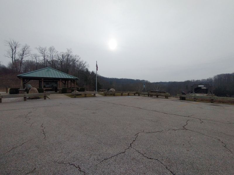
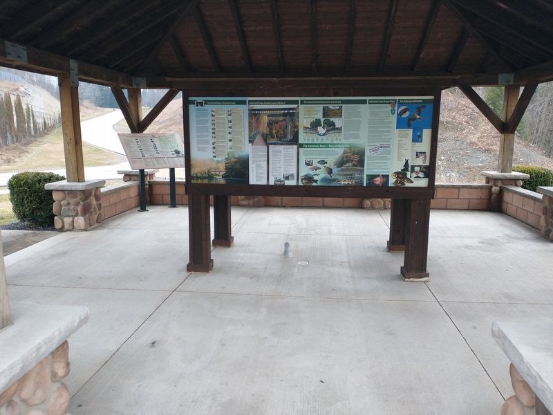
Edgewood in Ashtabula County, Ohio — The American Midwest (Great Lakes)
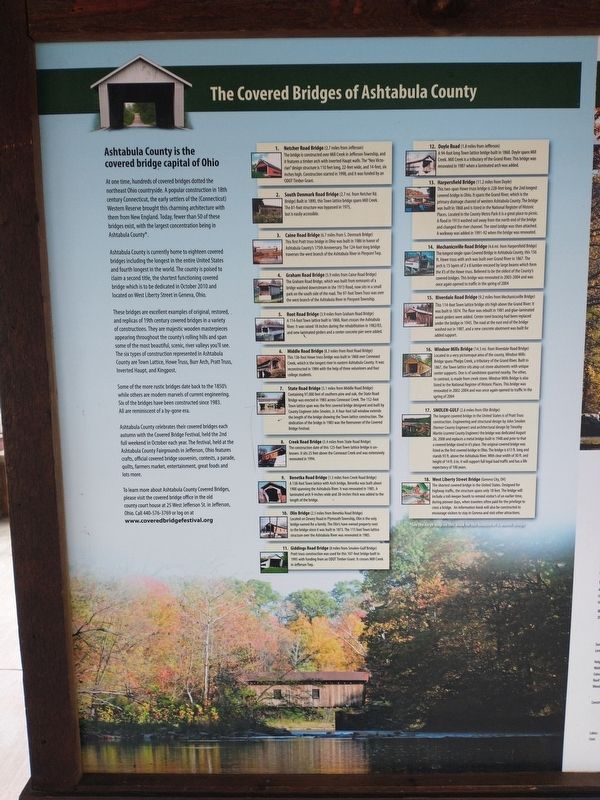
The Covered Bridges Of Ashtabula County
Ashtabula County is the covered bridge capital of Ohio
At one time, hundreds of covered bridges dotted the northeast Ohio countryside. A popular construction in 18th century Connecticut, the early settlers of the (Connecticut) Western Reserve brought this charming architecture with them from New England. Today, fewer than 50 of these bridges exist, with the largest concentration being in Ashtabula County*.
Ashtabula County is currently home to eighteen covered bridges including the longest in the entire United States and fourth longest in the world. The county is poised to claim a second title, the shortest functioning covered bridge which is to be dedicated in October 2010 and located on West Liberty Street in Geneva, Ohio.
These bridges are excellent examples of original, restored, and replicas of 19th century covered bridges in a variety of constructions. They are majestic wooden masterpieces appearing throughout the county's rolling hills and span some of the most beautiful, scenic, river valleys you'll see. The six types of construction represented in Ashtabula County are Town Lattice, Howe Truss, Burr Arch, Pratt Truss, Inverted Haupt, and Kingpost.
Some of the more rustic bridges date back to the 1850's while others are modern marvels of current engineering. Six of the bridges have been constructed since 1983. All are reminiscent of a by-gone era.
Ashtabula County celebrates their covered bridges each autumn with the Covered Bridge Festival, held the 2nd full weekend in October each year. The festival, held at the Ashtabula County Fairgrounds in Jefferson, Ohio features crafts, official covered bridge souvenirs, contests, a parade, quilts, farmers market, entertainment, great foods and lots more.
To learn more about Ashtabula County Covered Bridges, please visit the covered bridge office in the old county court house at 25 West Jefferson St. in Jefferson, Ohio. Call 440-576-3769 or log on at www.coveredbridgefestival.org
1. Netcher Road Bridge (2.7 miles from Jefferson)
The bridge is constructed over Mill Creek in Jefferson Township, and it features a timber arch with inverted Haupt walls. The "Neo Victorian" design structure is 110 feet long, 22-feet wide, and 14-feet, six inches high. Construction started in 1998, and it was funded by an ODOT Timber Grant
2. South Denmark Road Bridge (2.7 mi, from Netcher Rd.)
Built in 1890, this Town lattice bridge spans Mill Creek. The 81-foot structure was bypassed in 1975, but is easily accessible.
3. Caine Road Bridge (6.7 miles from S. Denmark Bridge)
This first Pratt truss bridge in Ohio was built in 1986 in honor of Ashtabula County's 175th Anniversary. The 124-foot long bridge traverses the west branch of the Ashtabula River in Pierpont Twp.
4. Graham Road Bridge (5.9 miles from Caine Road Bridge)
The Graham Road Bridge, which was built from remnants of a bridge washed downstream in the 1913 flood, now sits in a small park on the south side of the road. The 97-foot Town Truss was over the west branch of the Ashtabula River in Pierpont Township.
5. Root Road Bridge (3.9 miles from Graham Road Bridge)
A 114-foot Town lattice built in 1868, Root crosses the Ashtabula River. It was raised 18 inches during the rehabilitation in 1982/83, and new laminated girders and a center concrete pier were added.
6. Middle Road Bridge (8.3 miles from Root Road Bridge)
This 136-foot Howe truss bridge was built in 1868 over Conneaut Creek, which is the longest river in eastern Ashtabula County. It was reconstructed in 1984 with the help of three volunteers and four college students.
7. State Road Bridge (5.1 miles from Middle Road Bridge)
Containing 97,000 feet of southern pine and oak, the State Road Bridge was erected in 1983 across Conneaut Creek. The 152-foot Town lattice span was the first covered bridge designed and built by County Engineer John Smolen, Jr. A four-foot tall window extends the length of the bridge showing the Town lattice construction. The dedication of the bridge in 1983 was the forerunner of the Covered Bridge Festival
8. Creek Road Bridge (3.4 miles from State Road Bridge)
The construction date of this 125-foot Town lattice bridge is unknown. It sits 25 feet above the Conneaut Creek and was extensively renovated in 1994
9. Benetka Road Bridge (1.5 miles from Creek Road Bridge)
A 138-foot Town lattice with Arch bridge, Benetka was built about 1900 spanning the Ashtabula River. It was renovated in 1985. A laminated arch 9-inches wide and 38-inches thick was added to the length of the bridge.
10. Olin Bridge (2.5 miles from Benetka Road Bridge)
Located on Dewey Road in Plymouth Township, Olin is the only bridge named for a family. The Olin's have owned property next to the bridge since it was built in 1873. The 115 foot Town lattice structure over the Ashtabula River was renovated in 1985.
11. Giddings Read Bridge (8 miles from Smolen-Gulf Bridge)
Pratt truss construction was used for this 107-foot bridge built in 1995 with funding from an 000T Timber Grant. It crosses Mill Creek in Jefferson Twp.
12. Doyle Road (1.8 miles from Jefferson)
A 94-foot long Town lattice bridge built in 1868. Doyle spans Mill Creek. Mill Creek is a tributary of the Grand River. This bridge was renovated in 1987 when a laminated arch was added.
13. Harpersfield Bridge (11.2 miles from Doyle)
This two-span Howe truss bridge is 228-feet long, the 2nd longest covered bridge in Ohio. It spans the Grand River, which is the primary drainage channel of western Ashtabula County. The bridge was built in 1868 and is listed in the National Register of Historic Places. Located in the County Metro Park it is a great place to picnic. A flood in 1913 washed soll away from the north end of the bridge and changed the river channel. The steel bridge was then attached. A walkway was added in 1991-92 when the bridge was renovated.
14. Mechanicsville Road Bridge (4.6 mi. from Harpersfield Bridge)
The longest single-span Covered Bridge in Ashtabula County, this 156 ft. Howe truss with arch was built over Grand River in 1867. The arch is 15 layers of 2 x 8 lumber encased by large beams which form the X's of the Howe truss. Believed to be the oldest of the County's covered bridges. This bridge was renovated in 2003-2004 and was once again opened to traffic in the spring of 2004
15. Riverdale Road Bridge (9.2 miles from Mechanicsville Bridge)
This 114-foot Town lattice bridge sits high above the Grand River. It was built in 1874. The floor was rebuilt in 1981 and glue-laminated wood girders were added. Center steel bracing had been replaced under the bridge in 1945. The road at the east end of the bridge washed out in 1987, and a new concrete abutment was built for added support.
16. Windsor Mills Bridge (14.5 mi. from Riverdale Road Bridge)
Located in a very picturesque area of the county, Windsor Mills Bridge spans Phelps Creek, a tributary of the Grand River. Built in 1867, the Town lattice sits atop cut stone abutments with unique center supports. One is of sandstone quarried nearby. The other, in contrast, is made from creek stone. Windsor Mills Bridge is also listed in the National Register of Historic Places. This bridge was renovated in 2002-2004 and was once again opened to traffic in the spring of 2004
17. Smolen-Gulf (2.6 miles from Olin Bridge)
The longest covered bridge in the United States is of Pratt Truss construction Engineering and structural design by John Smolen (former County Engineer) and architectural design by Timothy Martin (current County Engineer) the bridge was dedicated August 26, 2008 and replaces a metal bridge built in 1948 and prior to that a covered bridge stood in it's place. The original covered bridge was listed as the first covered bridge in Ohia. The bridge is 613 ft. long and stands 93 ft. above the Ashtabula River. With clear width of 30 ft. and height of 14 ft. 6 in. it will support full legal load traffic and has a life expectancy of 100 years.
18. West Liberty Street Bridge (Geneva City, OH)
The shortest covered bridge in the United States. Designed for highway traffic, the structure spans only 18 feet. The bridge will include a toll-keeper booth to remind visitor's of an earlier time, during pioneer days, when travelers often paid for the privilege to cross a bridge. An information kiosk will also be constructed to encourage visitors to stay in Geneva and visit other attractions.
*See the large map on this kiosk for the location of a spectic fridge
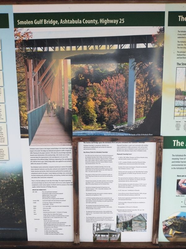
Smolen Gulf Bridge, Ashtabula County, Highway 25
Ashtabula County is home to the longest covered bridge in the United States; fourth longest in the world. The bridge was dedicated and opened to traffic in August of 2008. Planning for the project started in 1995 when the annual bridge inspection showed severe deterioration of the existing bridge. John Smolen was as much concerned about the improvements to the road alignment as he was to the replacement of the deficient bridge. Preliminary engineering of the road alignment left a 600 foot hole to span. Federal bridge dollars were applied for and received in 2000 in the amount of $5 million.
Two Ashtabula County construction companies teamed up to construct the project. Union Industrial Contractors was the prime contractor and completed the concrete, timber structure and erection. Koski Construction performed the excavation and embankment work for the project. County highway and bridge crews constructed the block retaining wall, performed seeding, and mulching, installed storm drainage and various other construction components.
There is a five foot walkway on each side of the bridge. The original engineering and structural design was done by John Smolen when he was county engineer and completed by current county engineer, Tim Martin with the assistance of the timber supplier, Sentinel Structures of Peshtigo, Wisconsin.
Smolen Gulf Bridge Facts:
2001-2005: Plans and specifications developed. Environmental studies and documents prepared. Additional right-of-ways secured. Wetland mitigation completed. EPA and Army Corp. of Engineer permits obtained
Summer 2006: Construction begins with land clearing and earthwork
Length: 613 feet long (longest in the United states) Overall length-626 feet
Height: 14'-6" dear height/93 feet above the Scenic Ashtabula River
Width: 30 feet clear width
Color: Olympus Green
Roof: Galvanized aluminum panels/1.256 pieces of 18 gauge
Wood: Southern Yellow Pine (siding Yellow Popular) 55,000 cubic feet of lumber or 670,000 board feet (52 load) Enough timber to cover a football field nearly 15 thick
Construction: Modified Pratt Truss 185,624 cubic yards of earth moved 2025 cubic yards of concrete for piers and abutments S86,000 pounds of galvanized steel reinforcement Rated to 80,000 lb full legal loach including tractor trailer traffic Life Expectancy of over 100 years
Labor: 30,000 labor hours-no lost time incidents
Cast: $5 million Federal Bridge dollars $1 million Ohio Public Works dollars 52 million Local Road and Bridge Fund dollars
The Smolen Gulf Bridge spans the Ashtabula River and joins Ashtabula and Plymouth Townships
Ashtabula Township is a prosperous suburban area with pleasant neighborhoods and sections for industrial and commercial activity. Plymouth Township is a quiet rural community with winding roads established on Indian and pioneer trails and has been referred to by some as Ashtabula County's green jewel as it is the link in the collection of gems that is Ashtabula County Plymouth Township Facts*
Key History Points for Ashtabula Township*
The 1950's were the real boom years of industrial development for Ashtabula Township. Union Carbide, the Electrical Power Plant, Hooker-Detrex Corporation, National Distillers, Bridgeport Brass, Union-Carbide-Linde Air, Stauffer-Chemical Company, General Tire Company, and Archer-Daniels-Midland Company were all built between 1950-1955.
The oldest church in Ashtabula Township is the East Side Presbyterian Church located at the southeast corner of Sweet Park on what was then State Road but now called Edgewood Drive. The church was built in 1852.
The property at Peleg Sweet Park was donated for public use by Mr. Peleg Sweet at about the same time the township was settled.
Chestnut Grove Cemetery, the oldest cemetery in the township, was begun in 1810. It is the home of the monument to those killed in the railroad disaster over the Ashtabula River. The full time Ashtabula Township Fire Department was started on January 1, 1974. It now offers ambulance, EMT, and paramedic services.
The Ashtabula Township voters passed a resolution adopting zoning rules and regulations in 1961.
The Ashtabula Township Road Department maintains approximately 34 miles of roadway and offers a wide variety of road and right-of-way services.
In 1976 the township meeting room was constructed to seat sixty people. Today this room located at 2718 North Ridge Road East is used for a variety of meetings, non-profit organizations, and resident gatherings.
The Edgewood School System became a State qualified high school in 1935. It was located in what is today's Braden Junior High School.
The Ashtabula Mall was constructed in 1991 that provided the primary shopping center for the township, which began the growth for the main commercial corridor. It is now termed as the Ashtabula Town Square.
Plymouth Township Facts*
In 1804 or 1805, William Thompson and Thomas McGahhe along with their families located on lot number 5.
In 1811, a number of families arrived from Plymouth Hollow, Litchfield County, Connecticut and settled in the township.
By order of the County Commissioners, Plymouth was detached from Ashtabula in January 7, 1838.
The first road in the township was the "Old Gridled Road" running from Kelloggsville via Sheffield, through Plymouth, and west to Cleveland.
The road running from Ashtabula to Jefferson was one of the very early ones once the "Big Marsh was drained, which gave communication with the county seat easier.
The first schoolhouse was built in the summer of 1810. It was of logs and stood in the "hollow"; a short distance from cemetery. The first teacher was Warner Mann.
In 1877, there were 7 schoolhouses in Plymouth. A saw-mill was erected in Plymouth Township in 1809, and upon the site there afterwards sprang up a woolen mill.
The first church organization started April 28, 1836 and was that of the Episcopal denomination.
The first post office in Plymouth Township was established on June 16, 1846.
The population in 1870 was 657 in Plymouth.
*Information taken from Ashtabula County Atlas 1905 and 1798 History of Ashtabula County, Ohio
Topics and series. This historical marker is listed in these topic lists: Animals • Bridges & Viaducts • Roads & Vehicles • Waterways & Vessels. In addition, it is included in the Covered Bridges series list. A significant historical date for this entry is January 1, 1974.
Location. 41° 51.36′ N, 80° 45.564′ W. Marker is in Edgewood, Ohio, in Ashtabula County. Marker is on State Road South (County Road 25) 0.3 miles north of Plymouth Ridge Road, on the right when traveling west. Touch for map. Marker is at or near this postal address: 4878 Plymouth Ridge Rd, Ashtabula OH 44004, United States of America. Touch for directions.
Other nearby markers. At least 8 other markers are within 2 miles of this marker, measured as the crow flies. Welcome To Ashtabula County Ohio (here, next to this marker); Indian Trails Park - Master Plan (here, next to this marker); Ashtabula County Museums & Historical Points of Intrest (here, next to this marker); Hotel Ashtabula (approx. 1.3 miles away); Henry Kalinowski (approx. 1.4 miles away); Civil War Memorial (approx. 1.4 miles away); This Veterans Memorial (approx. 1.4 miles away); World War II Memorial (approx. 1.4 miles away). Touch for a list and map of all markers in Edgewood.
Credits. This page was last revised on January 20, 2023. It was originally submitted on January 15, 2023, by Craig Doda of Napoleon, Ohio. This page has been viewed 203 times since then and 53 times this year. Photos: 1, 2, 3, 4, 5, 6. submitted on January 15, 2023, by Craig Doda of Napoleon, Ohio. • Devry Becker Jones was the editor who published this page.
