Alexandria West , Virginia — The American South (Mid-Atlantic)
Cabin in Historic Fairfax County
City of Alexandria, est. 1749
| — | Alexandria Heritage Trail | — |
Photographed by Devry Becker Jones (CC0), January 15, 2023
1. Cabin in Historic Fairfax County Marker
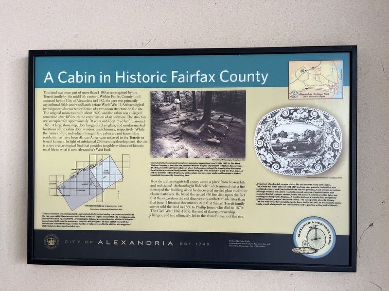
This land was once part of more than 1,100 acres acquired by the Terrett family by the mid-19th century. Within Fairfax County until annexed by the City of Alexandria in 1952, the area was primarily agricultural fieldsd and woodlands here before World War II. Archaeological investigations discovered evidence of a two-room structure on the site. The original room was built about 1800, and the cabin was enlarged sometime after 1830 with the construction of an addition. The structure was occupied for approximately 70 years until destroyed by fire around 1870. A large stone step, door hinges, broken glass, and mortar marked locations of the cabin door, window, and chimney, respectively. While the names of the individuals living in the cabin are not known, the residents may have been African Americans enslaved to the Terretts or tenant farmers. In light of substantial 20th-century development, the site is a rare archaeological find that provides tangible evidence of historic rural life in what is now Alexandria's West End.
How do archaeologists tell a story about a place from broken bits and soil stains? Archaeologist Bob
this page online
[Captions:]
The excavations in archaeological grid squares yielded information leading to a conjectural outline of the two-room cabin. Hand-wrought nails found to the east (right) indicate that a 12-foot square, wood structure was built by about 1800. Archaeologists deduced a construction date of or after 1830 for the second room (left) from the presence of cut nails, which began to be made at the time with the introduction of new technology. The low number of nails recovered in the addition also suggested that it may have been constructed of logs.
International Archaeological Consultants conducted excavations from 1991 to 1993 for The Mark Winkler Company at the cabin site, recorded with the Virginia Department of Historic Resources as 44AX162. Even though trees had grown where the house once stood, the investigation discovered the structure's presence through stones demarcating one side, evidence of a drip-line from the roof, and the presence of brick fragments, window glass, mortar, oyster shells, and hundreds of broken household items used by those living here.
A fragment of an English ceramic platter like this one was found at the cabin. The platter was made between 1813-1829 and may have graced a table which also contained oysters, pork (particularly head and feet portions), beef, chicken or venison. Although isolated, the cabin's residents enjoyed a degree of sophistication with abundant English tea cups, saucers, bowls and plates. Lanterns provided light, and cooking pots hung by the fireplace. A thimble, buttons, a bracelet link, and jewelry applique speak to women's work and values. Two slate pencils attest to literacy. The thin rods would have scratched white lines, similar to chalk, on a black slate tablet. Easily erased, slate pencils and tablets were used to practice writing and arithmetic.
Erected by City
Photographed by Devry Becker Jones (CC0), January 15, 2023
2. Cabin in Historic Fairfax County Marker
Topics and series. This historical marker is listed in these topic lists: Abolition & Underground RR • African Americans • Anthropology & Archaeology • Education • Settlements & Settlers. In addition, it is included in the Virginia, The City of Alexandria series list. A significant historical year for this entry is 1952.
Location. 38° 49.876′ N, 77° 7.067′ W. Marker is in Alexandria, Virginia. It is in Alexandria West. It is at the intersection of Mark Center Avenue and Mark Center Drive, on the left when traveling west on Mark Center Avenue. Touch for map. Marker is at or near this postal address: 4880 Mark Center Dr, Alexandria VA 22311, United States of America. Touch for directions.

Regionally, this marker is in the Washington Metropolitan Area and in Northern Virginia. It is also in the American South, specifically in the Upper South, in the Mid-Atlantic, and on the Eastern Seaboard. Globally, it is in the North Atlantic Region, North America, the Western Hemisphere, the Western World, and the Anglosphere. Historically, it finds itself in what was once the territory of the Mississippian Culture, one of the original Thirteen Colonies, one of the Confederate States of America, and the Antebellum South.
Other nearby markers. At least 8 other markers are within walking distance of this marker: An American Indian Camp in the Uplands (here, next to this marker); A Legacy of Conservation (approx. 0.3 miles away); Protecting Threatened Species (approx. 0.4 miles away); Dora Kelley Nature Park & Wildlife Sanctuary (approx. ¾ mile away); a different marker also named Outlying Gun Battery (approx. ¾ mile away); a different marker also named Southwest Bastion (approx. 0.8 miles away); Jackson Cemetery (approx. 0.8 miles away); Jackson Cemetery Memorial (approx. 0.8 miles away). Touch for a list and map of all markers in Alexandria.
Other markers no longer nearby. Outlying Gun Battery (was approx. ¾ mile away but has been replaced with another marker now near it); Southwest Bastion (was approx. 0.8 miles away but has been permanently removed).
Credits. This page was last revised on January 27, 2023. It was originally submitted on January 17, 2023, by Devry Becker Jones of Washington, District of Columbia. This page has been viewed 660 times since then and 41 times this year. Photos: 1, 2. submitted on January 17, 2023, by Devry Becker Jones of Washington, District of Columbia.
