Roxbury in Boston in Suffolk County, Massachusetts — The American Northeast (New England)
Roxbury
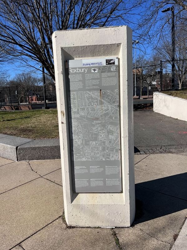
Roxbury, settled in 1630, is older than Boston. The early town centered around the meetinghouse in Eliot Square, where roads from inland towns merged into the only overland route to Boston.
For two hundred years Roxbury was mainly a rural community of farms and country estates. With the coming of the railroad in the nineteenth century, Roxbury became a pleasant suburb in which to live and locate industry.
It was the introduction of the streetcar in 1856, however, that triggered the transformation of Roxbury from a suburban haven to a dense urban neighborhood.
Since the 1850s, Roxbury has seen a shifting ethnic population from Irish to Jewish to Black. Currently it is the center for the Black community in Boston.
Roxbury Heritage State Park is an important key in helping to preserve Roxbury's special history and character by helping to promote preservation, conservation and development.
Roxbury's history is significant for its role in the Revolutionary War, for its being an example of a "streetcar suburb," and for its broad cross section of 19th century residential structures which are still used and lived
this page online
1. Museum of Fine Arts/Isabella Stewart Gardner Museum
Boston's two renowned art institutions are here on the Fenway. The MFA has a broad and deep collection of art through the centuries, while the Gardner is a monument to the personal vision of one collector.
2. Wentworth Institute of Technology
Wentworth Institute is a private undergraduate college offering programs in engineering technologies. Founded in 1904, Wentworth is well equipped to teach its curriculum of modern technology on its 35 acre urban campus.
3. Northeastern University
Northeastern University is the largest independent university in the nation. Founded in 1898 by the Boston YMCA, it has long been committed to providing access to higher education for all members of the community. Students prepare for professional careers through its cooperative education plan and extensive programs for adult, part-time students.
4. Madison Park Neighborhood
In 1966, the residents of Lower Roxbury banded together to form the non-profit Lower Roxbury Community Corporation (LRCC) to address their own housing needs. An example of their
![Southwest Corridor Park [Marker reverse] image. Click for full size.](Photos7/702/Photo702949.jpg?129202325100PM "Southwest Corridor Park [Marker reverse]. Click for full size.")
Photographed by Devry Becker Jones (CC0), January 27, 2023
2. Southwest Corridor Park [Marker reverse]
5. RHSP Gateway/Eliot Burial Ground
The Nawn Factory RHSP Visitor Center serves at the historic gateway to Roxbury and to Roxbury Heritage State Park. The adjacent Eliot Burial Ground dates back to the early 1600s and is the resting place of John Eliot and several colonial Massachusetts governors.
6. Crosstown Industrial Park
The Crosstown Industrial Park is a joint private/public venture of the Community Development Corporation of Boston and the Economic Development Industrial Commission. Their aim is to attract industry to the inner city, revitalize minority neighborhoods and to provide jobs.
Erected by Massachusetts Department of Conservation & Recreation.
Topics. This historical marker is listed in these topic lists: African Americans • Cemeteries & Burial Sites • Colonial Era • Education • Immigration • Industry & Commerce • Railroads & Streetcars • Settlements & Settlers. A significant historical year for this entry is 1630.
Location. 42° 20.12′ N,

Regionally, this marker is in Historic Boston. It is also in the American Northeast, in New England, and on the Eastern Seaboard. Globally, it is in the North Atlantic Region, North America, the Western Hemisphere, the Western World, and the Anglosphere. Historically, it finds itself in what was once one of the original Thirteen Colonies.
Other nearby markers. At least 8 other markers are within walking distance of this marker: Four Letters Home (about 300 feet away, measured in a direct line); Seventeenth and Eighteenth Centuries (about 500 feet away); Eighteenth and Nineteenth Centuries (about 500 feet away); Nineteenth and Twentieth Centuries (about 500 feet away); Sgt. William E. Carter Playground (approx. 0.3 miles away); Orchards and Gardens: Agricultural Innovation (approx. 0.3 miles away); A Revolutionary View of Boston, 1776 (approx. 0.3 miles away); Roxbury "Puddingstone" (approx. 0.3 miles away). Touch for a list and map of all markers in Boston.
Credits. This page was last revised on January 29, 2023. It was originally submitted on January 29, 2023, by Devry Becker Jones of Washington, District of Columbia. This page has been viewed 630 times since then and 38 times this year. Photos: 1, 2, 3. submitted on January 29, 2023, by Devry Becker Jones of Washington, District of Columbia.
