Roxbury in Boston in Suffolk County, Massachusetts — The American Northeast (New England)
Seventeenth and Eighteenth Centuries

Photographed By Devry Becker Jones (CC0), January 27, 2023
1. Seventeenth and Eighteenth Centuries Marker
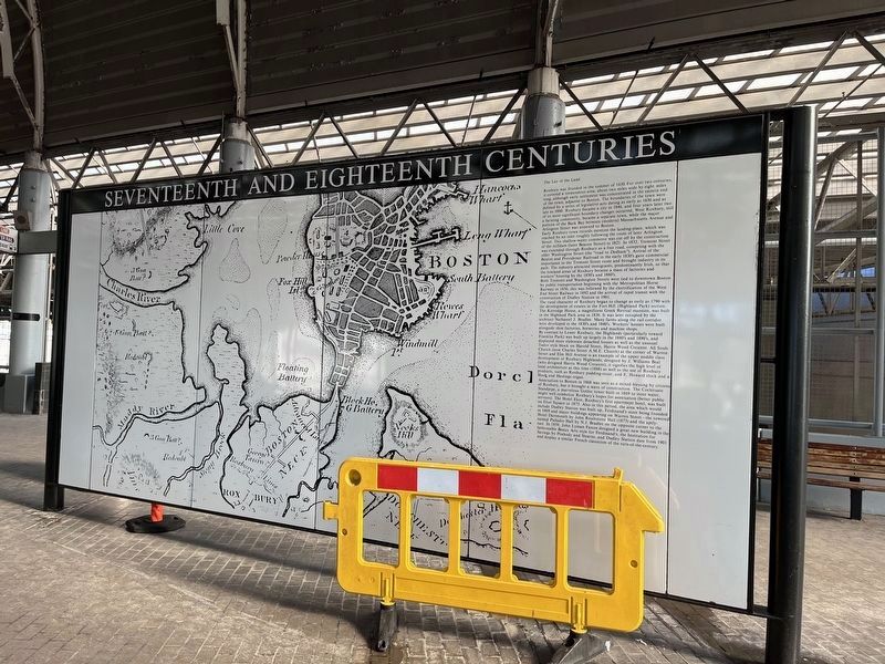
The Lay of the Land
Roxbury was founded in the summer of 1630. For over two centuries, it covered a tremendous area, about two miles wide by eight miles long, although early settlement was concentrated in the eastern end of the town, adjacent to Boston. The boundaries of the town were defined by a series of legislative acts dating as early as 1636 and as late as 1860. Roxbury became a city in 1846, and four years later two of its most significant boundary changes occurred, West Roxbury, still a farming community, became a separate town, while the major portion of the Back Bay between (modern) Massachusetts Avenue and Arlington Street was annexed to Boston.
Early Roxbury town records mentions the landing-place, which was reached by an inlet roughly following the route of later Arlington Street. This shallow-water commerce was cut off by the construction of the milldam (later Beacon Street) in 1821. In 1832, Tremont Street was extended through Roxbury as a free road, competing with the older Washington Street (the "road to Dedham"). Arrival of the Boston and Providence Railroad in the early 1830's gave commercial importance to the Tremont Street route and brought industry in its path. The industry attracted immigrants, predominantly Irish, so that the lowland areas of Roxbury became a mass of factories and workers' housing by the 1850's and 1860's.
Both Tremont and Washington Streets were tied to downtown Boston by public transportation beginning with the Metropolitan Horse Railway in 1856; this was followed by the electrification of the West End Street Railway in 1892 and the arrival of rapid transit with the construction of Dudley Station in 1901.
The rural character of Roxbury began to change as early as 1790 with the development of estates in the Fort Hill (Highland Park) section. The Kittredge House, a magnificent Greek Revival mansion, was built in the Highland Park area in 1836. It was later occupied by the architect Nathaniel J. Bradlee. Many farms along the rail corridor were developed in the 1830's and 1840's. Workers' houses were built alongside shoe factories, breweries and machine shops.
,br> By contrast to Lower Roxbury, the Highlands (particularly toward Franklin Park) was built up largely in the 1880's and 1890's, and displayed more elaborate detached houses as well as the unusual Tudor style block on Harold Street, Harris Wood Crescent. All Souls Church (now Charles Street A.M.E. Church) at the corner of Warren Street and Elm Hill Avenue is an example of the upper middle class development of Roxbury Highlands; designed by J. Williams Beal (who designed Harris Wood Crescent), it signifies the high level of local architecture at this time (1888)

Photographed By Devry Becker Jones (CC0), January 27, 2023
2. Seventeenth and Eighteenth Centuries Marker
Annexation to Boston in 1868 was seen as a mixed blessing by citizens of Roxbury, but it brought a wave of construction. the Cochituate Standpipe, a marvelous Gothic tower built in 1869 to store water, might as well symbolize Roxbury's hopes for annexation (better public services). The Hotel Eliot, Roxbury's first apartment hotel, was built on Eliot Square in 1875. Also in this period, the area which would include Dudley Station was built up, Ferdinand's store being founded in 1869 and major buildings appearing on Warren Street—the towered Hotel Dartmouth by John Roulestone Hall (1873) and the aptly-named Palladio Hall by N.J. Bradlee on the opposite corner to the east. In 1859, John Lyman Faxon designed a great new building in the fashionable Beaux Arts style for Ferdinand's; the Institution for Savings by Peabody and Stearns, and Dudley Station date from 1901 and display a similar French classicism of the turn-of-the-century.
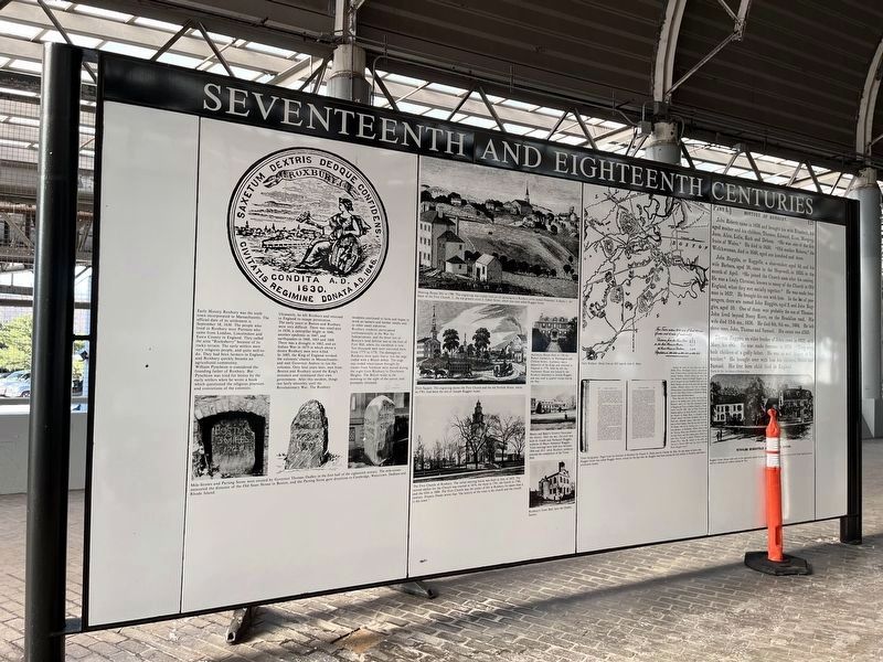
Early History Roxbury was the sixth town incorporated in Massachusetts town incorporated in Massachusetts. The official date of its settlement is September 18, 1630. The people who lived in Roxbury were Puritans who came from London, Lincolnshire and Essex County in England. They called the area "Rocksberry" because of its rocky terrain. The early settlers were very religious people, and quite well-to-do. They had been farmers in England, and Roxbury quickly became an agricultural community.
William Pyncheon is considered the founding father of Roxbury. But Pyncheon was tried for heresy by the early settlers when he wrote a book which questioned the religious practices and convictions of the colonists.
Ultimately, he left Roxbury and returned to England to escape persecution. The early years in Boston and Roxbury were very difficult. There was small-pox in 1636, a caterpillar blight in 1646, another epidemic in 1647, and earthquakes in 1660, 1663 and 1668. There was a drought in 1662, and an Indian War in 1675 in which about a dozen Roxbury men were killed. In 1685, the King of England revoked the colonists' charter in Massachusetts and sent Governor Andros to run the colonies. Only four years later, men from Boston and Roxbury seized the King's ministers and reinstated their own government. After this incident, things ran fairly smoothly until the Revolutionary War. The Roxbury residents continued to farm and began to work as tanners and leather smiths and in other small industries.
Roxbury residents participated enthusiastically in the War for Independence, and the front line of Boston's land defense was at the foot of Fort Hill, where the standpipe is now. Ten thousand men were stationed there from 1775 to 1776. The damages to Roxbury were quite heavy, but the siege was ended when canon brought by oxcart from Vermont were moving during the night from Roxbury to Dorchester Heights. The British woke in the morning to the sight of the canon and promptly retreated.
Topics. This historical marker is listed in these topic lists: Agriculture • Churches & Religion • Colonial Era • Roads & Vehicles • Settlements & Settlers. A significant historical date for this entry is September 18, 1630.
Location. 42° 20.172′ N, 71° 5.339′ W. Marker is in Boston, Massachusetts, in Suffolk County. It is in Roxbury. Marker can be reached from Southwest Corridor Park north of Columbus Avenue, on the right when traveling north. The marker stands in an open-air section of Ruggles Station. Touch for map. Marker is at or near this postal address: 1150 Tremont St, Roxbury Crossing MA 02120, United States of America. Touch for directions.
Other nearby markers. At least 8 other markers are within walking distance of this marker. Eighteenth and Nineteenth Centuries (here, next to this marker); Nineteenth and Twentieth Centuries (within shouting distance of this marker); Four Letters Home (within shouting distance of this marker); Roxbury (about 500 feet away, measured in a direct line); Sgt. William E. Carter Playground (approx. 0.2 miles away); Gen. Henry Knox Trail (approx. 0.4 miles away); Gardner Museum (approx. half a mile away); Titus Sparrow (approx. 0.7 miles away). Touch for a list and map of all markers in Boston.
Credits. This page was last revised on January 29, 2023. It was originally submitted on January 29, 2023, by Devry Becker Jones of Washington, District of Columbia. This page has been viewed 80 times since then and 16 times this year. Photos: 1, 2. submitted on January 29, 2023, by Devry Becker Jones of Washington, District of Columbia.