Oak Ridge in Roane County, Tennessee — The American South (East South Central)
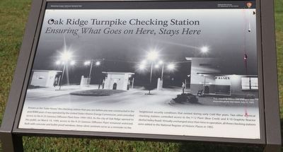
Oak Ridge Turnpike Checking Station
Ensuring What Goes on Here, Stays Here
— Manhattan Project National Historical Park —
Known as the “Gate House,” the checking station that you see before you was constructed in the post WWII years. It was operated by the United States Atomic Energy Commission , and controlled access to the K-25 Gaseous Diffusion Plant from 1949-1953. As the city of Oak Ridge opened to the public on March 19, 1949, access to the K-25 Gaseous Diffusion Plant remained restricted. Built with concrete and bullet-proof windows, these silent sentinels serve as a reminder to the heighten security conditions that existed during the early Cold War years. Two other identical checking stations controlled access to the Y-12 Plant (Bear Creek) and X-10 Graphite Reactor (Bethel Valley road). Virtually unchanged since their time in operation, all three checking stations were added to the National Register of Historic Places in 1992.
Erected by National PArk Service / U.S. Department of the Interior.
Topics. This historical marker is listed in these topic lists: Law Enforcement • Science & Medicine • War, Cold. A significant historical date for this entry is March 19, 1949.
Location. 35° 58.822′ N, 84° 20.07′ W. Marker is in Oak Ridge, Tennessee, in Roane County. Marker is on Oak Ridge Turnpike. Touch for map. Marker is at or near this postal address: 2900 Oak Ridge Turnpike, Oak Ridge TN 37830, United States of America. Touch for directions.
Other nearby markers. At least 8 other markers are within 5 miles of this marker, measured as the crow flies. Erected in Memory of New Bethel Baptist Church (approx. 3.6 miles away); The Wheat Community (approx. 3.7 miles away); Poplar Creek Seminary (approx. 3.7 miles away); The Robertsville Community (approx. 4 miles away); Midtown Community Center (approx. 4˝ miles away); L&N Cowcreel Branch (approx. 4˝ miles away); O.S. Engine #2 (approx. 4˝ miles away); The Emery Road (approx. 4˝ miles away). Touch for a list and map of all markers in Oak Ridge.
Also see . . . Oak Ridge Turnpike Checking Station Registration.
The Oak Ridge Turnpike Checking Station is composed of two separate concrete structures located opposite each other on the Oak Ridge Turnpike. The main building is located on the north side of the road and is one story in height with a two story tower at the southwest corner. On the south side of the road is a smaller one-story guard house. Both buildings are constructed adjacent to the road and there are no other buildings or structures associated with the property. (Submitted on February 1, 2023, by Dave W of Co, Colorado.)
Credits. This page was last revised on February 4, 2023. It was originally submitted on February 1, 2023, by Dave W of Co, Colorado. This page has been viewed 113 times since then and 16 times this year. Photo 1. submitted on February 1, 2023, by Dave W of Co, Colorado. • Bill Pfingsten was the editor who published this page.
