Waterfront in Boston in Suffolk County, Massachusetts — The American Northeast (New England)
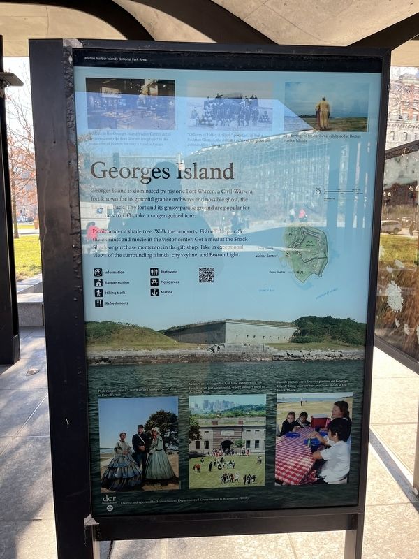
Georges Island
Boston Harbor Islands National Park Area
Georges Island is dominated by historic Fort Warren, a Civil-War-era fort known for its graceful granite archways and possible ghost, the Lady in Black. The fort and its grassy parade ground are popular for a scenic stroll. Or, take a ranger-guided tour.
Picnic under a shade tree. Walk the ramparts. Fish off the pier. See the exhibits and movie in the visitor center. Get a meal at the Snack Shack or purchase mementos in the gift shop. Take in exceptional views of the surrounding islands, city skyline, and Boston Light.
[Captions:]
Exhibits in the Georges Island Visitor Center detail the prominent role Fort Warren has played in the protection of Boston for over a hundred years.
"Officers of Heavy Artillery" posed in 1864 on a Rodman Cannon, the first in a series of weapons that defended Fort Warren.
The heritage of local tribes is celebrated on Harbor Islands.
Park rangers make Civil War-era history come alive at Fort Warren.
Visitors are brought back in time as they walk the Fort Warren parade ground, where soldiers used to drill and train.
Family picnics are a favorite pastime on Georges Island: bring your own or purchase meals at the Snack Shack.
Erected by National Park Service, U.S. Department of the Interior.
Topics. This historical marker is listed in these topic lists: Civil Rights • Forts and Castles • Native Americans • Parks & Recreational Areas. A significant historical year for this entry is 1864.
Location. 42° 21.604′ N, 71° 3.136′ W. Marker is in Boston, Massachusetts, in Suffolk County. It is in Waterfront. Marker is on Atlantic Avenue north of State Street, on the left when traveling north. Touch for map. Marker is at or near this postal address: 191w Atlantic Ave, Boston MA 02110, United States of America. Touch for directions.
Other nearby markers. At least 8 other markers are within walking distance of this marker. Lovells Island (here, next to this marker); Little Brewster Island (here, next to this marker); Peddocks Island (here, next to this marker); Boston Harbor Islands (here, next to this marker); Bumpkin Island (here, next to this marker); Spectacle Island (here, next to this marker); Thompson Island (here, next to this marker); Rose Fitzgerald Kennedy Greenway (within shouting distance of this marker). Touch for a list and map of all markers in Boston.
Credits. This page was last revised on February 4, 2023. It was originally submitted on February 4, 2023, by Devry Becker Jones of Washington, District of Columbia. This page has been viewed 66 times since then and 13 times this year. Photos: 1, 2. submitted on February 4, 2023, by Devry Becker Jones of Washington, District of Columbia.

