Near Leasburg in Caswell County, North Carolina — The American South (South Atlantic)
Griers Presbyterian Church
Caswell County Historical Association
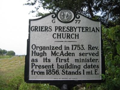
1. Griers Presbyterian Church Marker
Erected 1972 by North Carolina Office of Archives and History. (Marker Number G-77.)
Topics and series. This historical marker is listed in these topic lists: Cemeteries & Burial Sites • Colonial Era • Notable Buildings • Religion & Religious Structures. In addition, it is included in the North Carolina Division of Archives and History series list. A significant historical year for this entry is 1753.
Location. 36° 20.805′ N, 79° 13.706′ W. Marker is near Leasburg, North Carolina, in Caswell County. It is at the intersection of North Carolina Route 119 and Griers Church Road, on the left when traveling north on North Carolina Route 119. Touch for map. Marker is at or near this postal address: 1545 NC-119, Leasburg NC 27291, United States of America. Touch for directions.

Regionally, this marker is in North Carolina’s Piedmont. It is also in the American South and specifically in the Upper South. Globally, it is in North America, the Western Hemisphere, the Western World, and
this page online
Other nearby markers. At least 8 other markers are within 8 miles of this marker, measured as the crow flies: Solomon Lea (approx. 5.3 miles away); Jacob Thompson (approx. 5½ miles away); William L. Poteat (approx. 6½ miles away); Millstone Water Feature (approx. 7.1 miles away); Old Caswell County Jail (approx. 7.2 miles away); Old Poteat School (approx. 7.2 miles away); Public Watering Trough (approx. 7.2 miles away); Courthouse Fence (1861-1941) (approx. 7.2 miles away). Touch for a list and map of all markers in Leasburg.
More about this marker. While the marker is on US-19, the church building is east on Griers Church Road.
Also see . . . History of Griers Presbyterian Church. (Submitted on May 6, 2009, by Caswell County Historical Association of Yanceyville, North Carolina.)
Additional keywords. Upper Hyco/Hico, Caswell County
Credits. This page was last revised on February 21, 2023. It was originally submitted on May 6, 2009, by Caswell County Historical Association of Yanceyville, North Carolina. This page has been viewed 1,573 times since then and 47 times this year. Last updated on February 17, 2023, by Michael Buckner of Durham, North Carolina. Photo 1. submitted on May 6, 2009, by Caswell County Historical Association of Yanceyville, North Carolina. • Bernard Fisher was the editor who published this page.
