New London in New London County, Connecticut — The American Northeast (New England)
Changing Shoreline
New London Waterfront Park
( shore side )
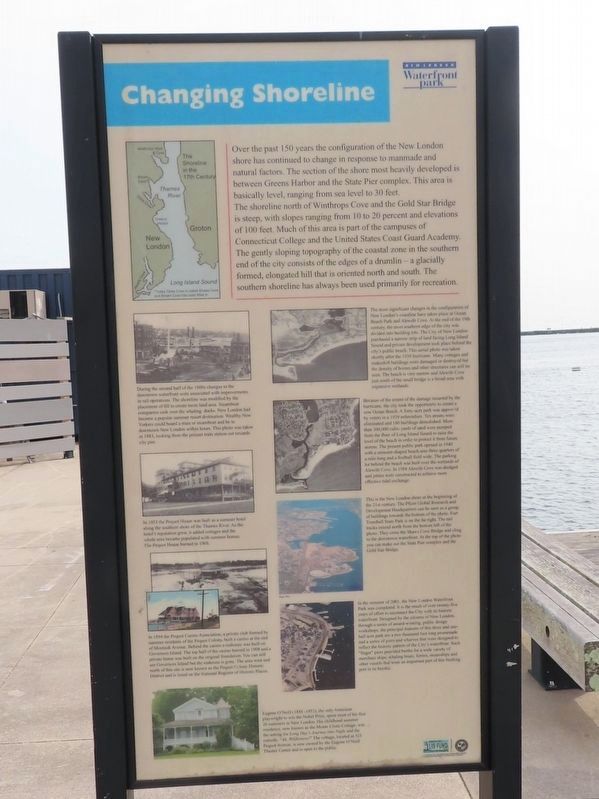
Over the past 150 years the configuration of the New London shore has continued to change in response to manmade and natural factors. The section of the shore most heavily developed is between Greens Harbor and the State Pier complex. This area is basically level, ranging from sea level to 30 feet.
The shoreline north of Winthrops Cove and the Gold Star Bridge is steep, with slopes ranging from 10 to 20 percent and elevations of 100 feet. Much of this area is part of the campuses of Connecticut College and the United States Coast Guard Academy.
The gently sloping topography of the coastal zone in the southern end of the city consists of the edges of a drumlin - a glacially formed, elongated hill that is oriented north and south. The southern shoreline has always been used primarily for recreation.
( photo captions )
During the second half of the 1800s changes to the downtown waterfront were associated with improvements in rail operations. The shoreline was modified by the placement of fill to create more land area. Steamboat companies took over the whaling docks. New London had become a popular summer resort destination. Wealthy New Yorkers could board a train or steamboat and be in downtown New London within hours. This photo was taken in 1883, looking from the present train station out towards city pier.
In 1853 the Pequot House was built as a summer hotel along the southern shore of the Thames River. As the hotel's reputation grew, it added cottages and the whole area became populated with summer homes. The Pequot House burned in 1908.
The most significant changes in the configuration of New London's coastline have taken place at Ocean Beach Park and Alewife Cove. At the end of the 19th century, the most southern edge of the city was divided into building lots. The City of New London purchased a narrow strip of land facing Long Island Sound and private development took place behind the city's public beach. This aerial photo was taken shortly after the 1938 hurricane. Many cottages and makeshift buildings were damaged or destroyed but the density of homes and other structures can still be seen. The beach is very narrow and Alewife Cove just south of the small bridge is a broad area with expansive wetlands.
Because of the extent of the damage incurred by the hurricane, the city took the opportunity to create a new Ocean Beach. A forty-acre park was approved by voters in a 1939 referendum. Ten streets were eliminated and 160 buildings demolished. More than 300,000 cubic yards of sand were pumped from the floor of Long Island Sound to raise the level of the beach in order to protect it from future storms. The present public park opened in 1940 with a crescent-shaped beach area three quarters of a mile long and a football field wide. The parking lot behind the beach was built over the wetlands of Alewife Cove. In 1988 Alewife Cove was dredged and jetties were constructed to achieve more effective tidal exchange.
This is the New London shore at the beginning of the 21st century. The Pfizer Global Research and Development Headquarters can be seen as a group of buildings towards the bottom of the photo. Fort Trumbull State Park is on the far right. The rail tracks extend north from the bottom left of the photo. They cross the Shaws Cove Bridge and cling to the downtown waterfront. At the top of the photo you can make out the State Pier complex and the Gold Star Bridge.
In 1894 the Pequot Casino Association, a private club formed by summer residents of the Pequot Colony, built a casino at the end of Montauk Avenue. Behind the casino a teahouse was built on Governors Island. The top half of the casino burned in 1908 and a private home was built on the original foundation. You can still see Governors Island but the teahouse is gone. The area west and north of this site is now known as the Pequot Colony Historic District and is listed on the National Register of Historic Places.
In the summer of 2001, the New London Waterfront Park was completed. It is the result of over twenty-five years of effort to reconnect the City with its historic waterfront. Designed by the citizens of New London, through a series of award-winning, public design workshops, the principal features of this three and one-half acre park are a two thousand foot long promenade and a series of piers and wharves that were designed to reflect the historic pattern of the City's waterfront. Such "finger" piers provided berths for a wide variety of merchant ships, whaling boats, ferries, steamships and other vessels that were an important part of this bustling port in its heyday.
Eugene O'Neill (1888-1953), the only American playwright to win the Nobel Prize, spent most of his first 26 summers in New London. His childhood summer residence, now known as the Monte Cristo Cottage, was the setting for Long Day's Journey into Night and the comedy, "Ah, Wilderness!" The cottage, located at 325 Pequot Avenue, is now owned by the Eugene O'Neill Theater Center and is open to the public.
( harbor side )
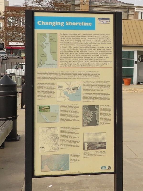
The Thames River and the New London shoreline were created during the last ice age when mile-high glaciers advanced and retreated across southern New England. As with any coastline, the New London shore is a dynamic landform, always in flux, always changing. Much of the shore north of Greens Harbor has been altered by manmade development, but south of that point shoreline change has been a combination of manmade and natural processes.
In the early 1600s, when the Pequots and the Mohegans were settled into the area now known as New London County, the shoreline was a natural world of trees, birds, fish, shellfish, deer, and wild plants. Even after the first permanent English settlers arrived here in 1646, the natural shoreline remained relatively unchanged except for several small private wharves constructed by local merchants to accommodate trade. The downtown waterfront area was referred to as "The Bank". The name was taken from the characteristic upland area located immediately above the sandy shore. Ten-foot-deep water at the shoreline allowed boats to berth right along the waterfront and, in several locations, right up to present day Bank Street, one of the first streets laid out in the City.
The 1700s were a time of growth for New London. In 1723-24 all of the land on the Bank was sold for private use and for the first time there were some modifications to the natural landform as the new property owners constructed bulkheads and wharves and filled in portions of the river to create more usable land area. Property on the waterfront was used for the construction of warehouses and storage facilities to support coastal maritime trade. During the height of the West Indian Trade, 1720-1770, as many as one hundred and fifty merchant vessels entered and cleared the port each year. However, the single most significant change occurred in 1781 when the British, led by Benedict Arnold, attacked and burned nearly every building, warehouse and wharf in the downtown in order to destroy the shipping activities of the port. The homes that skirted Bream Cove were just far enough away from the downtown waterfront to be spared.
( photo captions )
The stone house on Jay Street belonged to Nathaniel Hempsted, grandson of Joshua Hempsted, author of the Hempsted Diary, a chronicle of life in New London from 1728 to 1758. It is an unusual structure for New London and was probably built by French Acadians whom the British had exiled from Nova Scotia. When the home was built in 1759 it faced Bream Cove. Today it faces a busy intersection and is open to the public as one of the Antiquarian and Landmarks Society's two Hempstead Houses.
The Dutch Colonial home at 92 Washington Street was constructed in 1763 for William Coit. The Coits had been among the first settlers in New London. William was captain of the local militia during the Battle of Bunker Hill and the commander of the schooner Harrison, one of the first vessels commissioned by congress for the Revolutionary War. The home used to be adjacent to Bream Cove. Today it is part of the Coit Street Historic District, on the National Register of Historic Places, and is privately owned.
In 1756 Nathaniel Shaw began building what is now called the Shaw Mansion. Nathaniel was a successful shipping merchant and became the Naval War Agent for Connecticut during the War for Independence. He hired Acadian exiles to quarry stone from the property to build this elegant home on a Georgian central-hall plan. The New London County Historical Society purchased the home in 1907; it is open to the public.
The earliest development in New London occurred around Winthrops Cove and Bream Cove, which were used for the safe mooring of vessels. In 1650, John Winthrop Jr. commissioned a gristmill to be built at the end of Winthrops Cove. The mill was an important part of colonial life and served the entire community; it was rebuilt in 1781 after the burning of New London by the British and remained operating until 1913. Today the Old Town Mill is one of the State's oldest industrial sites. It is still in its original location but the surrounding area has changed considerably.
This aerial view of the Thames River was taken in 1980. The double-spanned Gold Star Bridge connects Interstate 95 between New London and Groton. The areas outlined in red are Winthrops Cove and Bream Cove. Winthrops Cove is a shadow of its former self; the Old Town Mill is dwarfed by the northbound lanes of Interstate 95. There is nothing left of Bream Cove. The entire area has been filled in.
During the 19th century New London's shore dramatically changed. The natural shoreline of the waterfront entirely disappeared as bulkheads were constructed and the river was filled in to create more land area to accommodate whaling activities. The docks were the focal point of the community. Wharves along the Bank were extended farther out into the river and acquired Ts and Ls to accommodate more vessels. In the early 1850s the railroad arrived in New London and cut across the waterfront wharves. For the first time in the town's history, there was no direct access to the waterfront. In this 1863 map, a railroad trestle bridge crosses Winthrops Cove and Bream Cove has begun to shrink.
This bird's-eye view of New London was done in 1876. The view is from Groton looking west across the river. Bream Cove has been entirely filled.
This painting, attributed to Frederick L. Allen, shows New London harbor from Fort Trumbull in 1854. The obelisk at Fort Griswold, built in 1831, stands solo on Groton Bank. The scene is alive with shipping up and down the river.
Topics. This historical marker is listed in these topic lists: Colonial Era • Industry & Commerce • Native Americans • Waterways & Vessels. A significant historical year for this entry is 1883.
Location. 41° 21.103′ N, 72° 5.695′ W. Marker is in New London, Connecticut, in New London County. Marker can be reached from the intersection of S Water Street and Bank Street Connector, on the right when traveling east. Located on the Custom House Pier. Touch for map. Marker is in this post office area: New London CT 06320, United States of America. Touch for directions.
Other nearby markers. At least 8 other markers are within walking distance of this marker. New London Harbor (within shouting distance of this marker); Middle Passage to New London (within shouting distance of this marker); The Amistad (within shouting distance of this marker); "Do you want to be slave or free?" (within shouting distance of this marker); New London Waterfront (within shouting distance of this marker); Whaling Days (about 300 feet away, measured in a direct line); 138 Bank Street (about 300 feet away); First Step to Freedom (about 300 feet away). Touch for a list and map of all markers in New London.
Credits. This page was last revised on May 6, 2023. It was originally submitted on February 18, 2023, by Michael Herrick of Southbury, Connecticut. This page has been viewed 149 times since then and 50 times this year. Photos: 1, 2, 3, 4. submitted on February 18, 2023, by Michael Herrick of Southbury, Connecticut.


