Cape Canaveral in Brevard County, Florida — The American South (South Atlantic)
Cape Canaveral's Native Americans
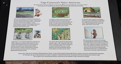
There are 95 recorded sites within the boundaries of the Cape Canaveral Space Force Station. Many of these sites are sand mounds used for burials or ceremonial purposes. There are also "middens" - refuse accumulations composed of discarded animal bones, shells and broken pottery. These middens were sometimes also used for burials.
Beginning in 1513, Spanish exploration of Florida and slavers seeking new captives first brought the Ais in contact with Europeans. They were also exposed to Spanish missionaries and shipwrecked travelers. Few interactions could be characterized as friendly. The Ais economy received a boost by salvaging shipwrecked European goods.
Ais villages consisted of several houses made of small poles stuck into the ground, bent towards each other and covered with palmetto fronds. On Cape Canaveral, they lived along the Indian River Lagoon and may have moved to the mainland for the winter months.
The name "Cabo Canaveral” first appeared on Spanish maps in 1564. Meaning "Cape of the Canes" or perhaps "Cape of the Cane Bearers”, it may have described the cane or reeds growing in the area and perhaps referred to the natives use of the cane for arrows.
The Ais were hunters, gatherers, and fishers, not farmers. Their main food was the plentiful fish, supplemented with oysters, clams and snails. They also gathered coco plums, sea grapes, palm berries, and sea oats.
Men decorated their bodies with markings resembling tattoos and wore pieces of platted grass which formed a loin cloth, fastened in the back with a collection of grasses resembling a horse's tail. Women wore skirts of woven moss and wore their hair long, hanging loosely. Men fastened their hair in a roll behind their head using curved pins made from bones.
Erected by Florida Lighthouse Association.
Topics. This historical marker is listed in these topic lists: Anthropology & Archaeology • Colonial Era • Exploration • Native Americans • Settlements & Settlers. A significant historical year for this entry is 1513.
Location. 28° 27.637′ N, 80° 32.604′ W. Marker is in Cape Canaveral, Florida, in Brevard County. Marker is on Lighthouse Road north of Control Tower Road, on the left when traveling north. Touch for map. Marker is in this post office area: Cape Canaveral FL 32920, United States of America. Touch for directions.
Other nearby markers. At least 8 other markers are within 2 miles of this marker, measured as the crow flies. Cape Canaveral Lighthouse (within shouting distance of this marker); Early Cape Life (within shouting distance of this marker); Cape Canaveral Light Station (about 300 feet away, measured in a direct line); a different marker also named Cape Canaveral Lighthouse (about 400 feet away); Launch Site of America's First Satellite, Explorer I / The Space Race Begins (approx. 2.1 miles away); Cape Canaveral Air Force Station (approx. 2.1 miles away); First United States Space Launch (approx. 2.1 miles away); Launch Complex 26 (approx. 2.1 miles away). Touch for a list and map of all markers in Cape Canaveral.
Also see . . . Cape Canaveral Lighthouse. (Submitted on March 5, 2023.)
Credits. This page was last revised on March 5, 2023. It was originally submitted on March 5, 2023, by Dave W of Co, Colorado. This page has been viewed 96 times since then and 19 times this year. Photos: 1, 2. submitted on March 5, 2023, by Dave W of Co, Colorado. • Bernard Fisher was the editor who published this page.

