Wawa in Algoma District, Ontario — Central Canada (North America)
Place of Clear Wawa Water

Photographed by Cosmos Mariner, June 6, 2022
1. Place of Clear Wawa Water Marker
I think you would agree that the Wawa town site is situated in the perfect spot — a level plain on the shores of a picturesque lake of crystal green water surrounded by rolling mountains of natural abundance. Wawa's Ojibway ancestors, early American tourists and our founding residents would agree with you!
The origin of Wawa's unique name is found in the Ojibway language. Some believe that the word "wawa" was Ojibway for wild goose, referring to the regular flocks that migrate over Wawa every year. The word "wewe" is translated as snow goose, a close relative to the Canada Goose that is common in Northern Ontario.
When early prospectors, tourists and sportsmen first explored and fished the Wawa area, their native guides told them that Wawa Lake was called "wawagonk" meaning place of clear water. This original Ojibway name may have been shortened to give us the unique name of Wawa which we use today.
The Michipicoten Ojibway regularly camped on the shores of Wawa Lake. It was a prime fishing location and resting place on a popular portage and trading route from Michipicoten Bay on Lake Superior to Missinaibi and James Bay.
this page online
In the 1880's Mormon teamsters were the first Europeans to inhabit the western shoreline of Wawa Lake. These labourers were contracted for the crucial job of transferring rails, supplies and manpower from Michipicoten Bay on Lake Superior to crews working on the completion of the Canadian Pacific Railway in the Missanabie/Chapleau regions. The whole transportation process covered a distance of 100 kilometres through endless forests, swamps, lakes and crisscrossing rivers.
The Lakeview Hotel occupies the site where the Mormon contractors set up camp during their freighting operations. A small steamboat was used to aid in the transportation of supplies across Wawa Lake. The steamboats metal boiler and rotting wooden hull was once a unique relic for children to explore during family picnics along the shore. Keep your eyes open for old horse and mule shoes! You never know where they might be found.
Wawa residents are happy to boast
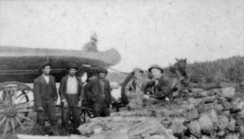
2. Marker detail: Detroit fisherman and Michipicoten guides traveling the Mormon Trail, 1910
Topics. This historical marker is listed in these topic lists: Indigenous Peoples and Communities • Railroads & Streetcars • Settlements & Settlers • Waterways & Vessels.
Location. 47° 59.918′ N, 84° 46.24′ W. Marker is in Wawa, Ontario, in Algoma District. It is on Broadway Avenue just north of Laurier Street, on the right when traveling north. Marker is located on the Lion's Beachfront Heritage Walk. Touch for map. Marker is in this post office area: Wawa ON P0S 1K0, Canada. Touch for directions.

Regionally, this marker is in the Sault Ste. Marie and Algoma Area and in Northern Ontario. It is also in Central Canada. Globally, it is in North America, in the Great North Woods, on the Great Lakes, on Lake Superior’s North Shore, in the Western Hemisphere, in the Western World, and in the Anglosphere. Historically, it finds itself in what was once a British colony, the Viceroyalty of New France,

3. Marker detail: Wawa Townsite, 1920’s
Other nearby markers. At least 8 other markers are within walking distance of this marker: Monument to Mining (within shouting distance of this marker); Wawa's Golden Hills & Mountains of Iron (within shouting distance of this marker); Wawa Lake Tales from Above and Below (within shouting distance of this marker); Artillo Berdusco (about 90 meters away, measured in a direct line); Mickey Clement (about 90 meters away); Thomas Surluga (about 90 meters away); Francis Hector Clergue (about 90 meters away); Rod Morrison (about 90 meters away). Touch for a list and map of all markers in Wawa.

4. Marker detail: Family picnic and fishing on Wawa Lake, 1930’s

5. Marker detail: Early residents enjoying a boat ride on Wawa Lake, c.1940

Photographed by Cosmos Mariner, June 6, 2022
6. Place of Clear Wawa Water Marker

Photographed by Cosmos Mariner, June 6, 2022
7. Lion's Beachfront Heritage Walk
Credits. This page was last revised on March 18, 2023. It was originally submitted on March 18, 2023, by Cosmos Mariner of Cape Canaveral, Florida. This page has been viewed 501 times since then and 113 times this year. Photos: 1, 2, 3, 4, 5, 6, 7. submitted on March 18, 2023, by Cosmos Mariner of Cape Canaveral, Florida.
