Weches in Houston County, Texas — The American South (West South Central)
Kings Highway Camino Real — Old San Antonio Road
Marker #24
| — | El Camino Real de los Tejas National Historic Trail | — |

Photographed by Benchmark Blasterz, December 30, 2017
1. Kings Highway Camino Real — Old San Antonio Road Marker #24
Marked by The Daughters of The American Revolution and The State of Texas A.D. 1918
Erected 1918 by The Daughters of The American Revolution and The State of Texas. (Marker Number 24.)
Topics and series. This historical marker is listed in these topic lists: Colonial Era • Roads & Vehicles. In addition, it is included in the Daughters of the American Revolution (DAR) series list. A significant historical year for this entry is 1918.
Location. 31° 31.6′ N, 95° 14.879′ W. Marker is in Weches, Texas, in Houston County. It is on State Highway 21 just west of Farm to Market Road 227, on the right when traveling west. Touch for map. Marker is in this post office area: Grapeland TX 75844, United States of America. Touch for directions.

Regionally, this marker is in the American South, specifically in the Deep South, and in the Piney Woods. Globally, it is in North America, a Gulf of Mexico state, the Western Hemisphere, the Western World, and the Anglosphere. Historically, it finds itself in what was once New Spain, the Republic of Texas, one of the Confederate States of America, and the Antebellum South.
Other nearby markers. At least 8 other markers are within 5 miles of this marker, measured as the crow flies: Weches CCC Camp (approx. ¾ mile away); Glover School (approx. one mile away); Mission San Francisco de Los Tejas (approx. 1.3 miles away); The Joseph R. Rice Log Cabin (approx. 1.4 miles away); Mission San Francisco de los Tejas (approx. 1.6 miles away); Community of Weches (approx. 1.7 miles away); a different marker also named Kings Highway Camino Real — Old San Antonio Road (approx. 2.8 miles away); Pine Springs Campground (approx. 4.2 miles away). Touch for a list and map of all markers in Weches.
this page online
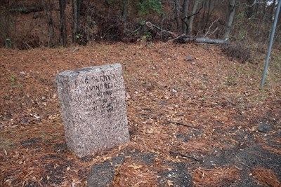
Photographed by Benchmark Blasterz, December 30, 2017
2. Kings Highway Camino Real — Old San Antonio Road Marker #24
Credits. This page was last revised on April 23, 2023. It was originally submitted on March 29, 2023, by Carolyn Sanders of Plano, Texas. This page has been viewed 202 times since then and 26 times this year. Photos: 1, 2. submitted on March 29, 2023, by Carolyn Sanders of Plano, Texas. • J. J. Prats was the editor who published this page.
