Carroll Park in Baltimore, Maryland — The American Northeast (Mid-Atlantic)
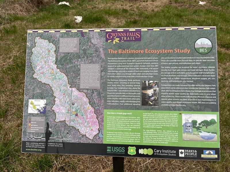
The Baltimore Ecosystem Study
Gwynns Falls Trail
Metropolitan Baltimore is a human-dominated ecological system. The Baltimore Ecosystem Study (BES), part of the National Science Foundation's Long-Term Ecological Research Network, conducts research to understand how this system changes over time. BES research is centered on the Gwynns Falls watershed, a 64 square mile drainage area with a variety of land uses ranging from Baltimore City's urban core, through older urban and suburban zones, to rapidly suburbanizing areas and a rural/suburban fringe.
The Baltimore Ecosystem Study performs weekly stream sampling at several long-term study sites. This sampling network includes for longitudinal sites along the Gwynns Falls—one of which is located here. These sites provide data on the quality and quantity of water in different land use zones of the Gwynns Falls watershed: urban core, older suburban, rapidly suburbanizing and rural-suburban. Four additional sampling sites are in smaller watersheds in or near the Gwynns Falls. These sites provide more focused data on specific land use areas of forest, agricultural, rural-suburban and urban.
The stream samples are analyzed for water chemistry: chloride (mostly from road salt); nitrate and total nitrogen (from fertilizers, sewage and air pollution); and phosphate and total phosphorus (from fertilizers and sewage). Other indicators of stream water quality such as sulfate temperature, dissolved oxygen, pH, conductivity and turbidity are also tracked.
Comparisons are made between the sites within the Gwynns Falls watershed and to reference sites outside the Gwynns Falls watershed. The resulting data have shown that biological processes that improve stream water quality are important, even in very urban areas of the City. These results indicate that efforts to improve and restore urban streams are likely to produce real improvements in water quality and stream ecosystem health. BES data are publicly available at http://beslter.org.
Erected by U.S. Geological Survey, U.S. Department of the Interior; Forest Service, U.S. Department of Agriculture; Cary Institute of Ecosystem Studies; Parks & People Foundation; Chesapeake Bay Gateways Network.
Topics and series. This historical marker is listed in these topic lists: Environment • Science & Medicine • Waterways & Vessels. In addition, it is included in the Maryland, Gwynns Falls Trail series list.
Location. 39° 16.303′ N, 76° 38.892′ W. Marker is in Baltimore, Maryland. It is in Carroll Park. Marker is on Washington Boulevard (Alternate U.S. 1) south of Western Avenue, on the right when
Other nearby markers. At least 8 other markers are within walking distance of this marker. Of Fords, Felles, and Falls (here, next to this marker); Carroll Park at the Golf Course (a few steps from this marker); Carroll Park Golf Course (about 300 feet away, measured in a direct line); Carroll Park (approx. 0.4 miles away); Carrollton Viaduct (approx. half a mile away); Mount Clare (approx. 0.6 miles away); Camp Carroll (approx. 0.6 miles away); a different marker also named Mount Clare (approx. 0.6 miles away). Touch for a list and map of all markers in Baltimore.
Related marker. Click here for another marker that is related to this marker. This marker has replaced the linked marker.
Additional commentary.
1. About the marker
While this marker features no historical information, it is included as part of the Gwynns Falls Trail series.
— Submitted April 8, 2023, by Devry Becker Jones of Washington, District of Columbia.
Credits. This page was last revised on April 8, 2023. It was originally submitted on April 8, 2023, by Devry Becker Jones of Washington, District of Columbia. This page has been viewed 66 times since then and 10 times this year. Photos: 1, 2. submitted on April 8, 2023, by Devry Becker Jones of Washington, District of Columbia.

