Ormond Beach in Volusia County, Florida — The American South (South Atlantic)
The Timucua
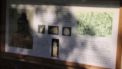
The Timucua were a Native American nation that lived in northeastern and central Florida. Nocoroco, here on Tomoka Point was the first Timucuan village encounter by Spanish explorers as they traveled south from St. Augustine. Timucuan villages were ruled by a chief. Social position in a clan was passed through the mother’s brother.
Daily life included gathering shellfish, fishing, and growing crops such as corn and squash. Meals were communally cooked in the village. Clans had a religious leader that conducted ceremonies for the important activities of the village.
At the time of European contact the population was believed to be tens of thousands. By 1698 exposure to European diseases devastated the Timucua to less than 1000. The last known Timucuan died in 1767.
Topics. This historical marker is listed in these topic lists: Anthropology & Archaeology • Colonial Era • Exploration • Native Americans.
Location. 29° 21.281′ N, 81° 5.387′ W. Marker is in Ormond Beach, Florida, in Volusia County. Touch for map. Marker is at or near this postal address: 2099 Unnamed Road, Ormond Beach FL 32174, United States of America. Touch for directions.
Other nearby markers. At least 8 other markers are within 5 miles of this marker, measured as the crow flies. Mount Oswald Plantation (within shouting distance of this marker); Nocoroco (within shouting distance of this marker); Tomoka Point (about 400 feet away, measured in a direct line); Dummitt Plantation Mill Ruins (approx. one mile away); World War II Coastal Watch Tower (approx. 1.6 miles away); Old King's Road (approx. 2.3 miles away); Ormond Tomb (approx. 3.3 miles away); First Christian Marriage In North America (approx. 4.4 miles away). Touch for a list and map of all markers in Ormond Beach.
Credits. This page was last revised on April 17, 2023. It was originally submitted on April 17, 2023, by Dave W of Co, Colorado. This page has been viewed 85 times since then and 16 times this year. Photos: 1, 2. submitted on April 17, 2023, by Dave W of Co, Colorado. • Devry Becker Jones was the editor who published this page.

