Warren in Bristol County, Rhode Island — The American Northeast (New England)
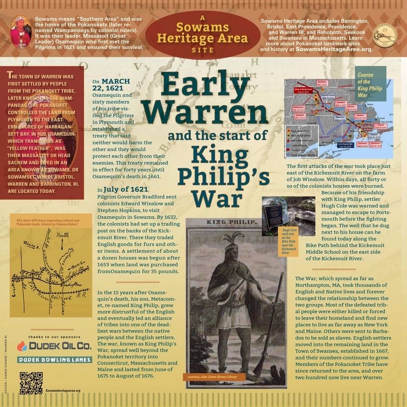
Early Warren and the start of King Philip's War
The town of Warren was first settled by people from the Pokanoket Tribe, later known as the Wampanoag. The Pokanoket controlled the land from Plymouth to the eastern shores of Narragansett Bay. In 1620, “Osamequin”, which translates as “Yellow Feather”, was their Massasoit or head Sachem and lived in an area known as “Sowams” or “Sowamset” where Bristol, Warren and Barrington, RI, are located today.
On March 22, 1621, Osamequin and sixty members of his tribe visited the Pilgrims in Plymouth and established a treaty that said neither would harm the other and they would protect each other from their enemies. This treaty remained in effect for forty years until Osamequin’s death in 1661.
In July of 1621, Pilgrim Governor Bradford sent colonists Edward Winslow and Stephen Hopkins, to visit Osamequin in Sowams. By 1632, the colonists had set up a trading post on the banks of the Kickemuit River. There they traded English goods for furs and other items. A settlement of about a dozen houses was begun after 1653 when land was purchased from Osamequin for 35 pounds.
In the 15 years after Osamequin’s death, his son, Metacomet, grew more distrustful of the English and eventually led an alliance of tribes into one of the deadliest wars between the native people and the English settlers. The war, known as King Philip’s War, spread well beyond the Pokanoket territory into Connecticut, Massachusetts and Maine and lasted from June of 1675 to August of 1676.
The first attacks of the War took place just east of the Kickemuit River on the farm of Job Winslow. Within days, all forty or so of the colonists houses were burned. Because of his friendship with King Philip, settler Hugh Cole was warned and managed to escape to Portsmouth before the fighting began. The well that he dug next to his house can be found today along the Bike Path behind the Kickemuit Middle School on the east side of the Kickemuit River.
The War, which spread as far as Northampton, MA, took thousands of English and Native lives and forever changed the relationship between the two groups. Most of the defeated tribal people were either killed or forced to leave their homeland and find new places to live as far away as New York and Maine. Others were sent to Barbados to be sold as slaves. English settlers moved into the remaining land in the Town of Swansea, established in 1667, and their numbers continued to grow. Members of the Pokanoket Tribe have since returned to the area, and over two hundred now live near Warren.
Erected by Sowams Heritage Area Project, Inc.
Topics. This historical marker is listed in these topic lists: Colonial Era • Native Americans • Settlements & Settlers • Wars, US Indian. A significant historical date for this entry is June 24, 1675.
Location. 41° 43.823′ N, 71° 15.561′ W. Marker is in Warren, Rhode Island, in Bristol County. Marker is at the intersection of Child Street (Rhode Island Route 103) and Hugh Cole Road, on the right when traveling east on Child Street. Touch for map. Marker is at or near this postal address: 525 Child Street, Warren RI 02885, United States of America. Touch for directions.
Other nearby markers. At least 8 other markers are within 2 miles of this marker, measured as the crow flies. In Memory of Hugh Cole (approx. 0.3 miles away); Vietnam Memorial (approx. ¾ mile away); Warren, RI (approx. 1.2 miles away); Washington St. (approx. 1.2 miles away); Baptist Church in Warren, R.I. (approx. 1.2 miles away); a different marker also named The Baptist Church in Warren (approx. 1.2 miles away); The Warren Armory (approx. 1.2 miles away); Veterans Memorial (approx. 1.2 miles away). Touch for a list and map of all markers in Warren.
Also see . . . Sowams Heritage Area. (Submitted on May 24, 2023, by Michael Herrick of Southbury, Connecticut.)
Credits. This page was last revised on May 24, 2023. It was originally submitted on May 20, 2023, by David Weed of Warren, Rhode Island. This page has been viewed 87 times since then and 32 times this year. Photos: 1, 2. submitted on May 20, 2023, by David Weed of Warren, Rhode Island. • Michael Herrick was the editor who published this page.

