Arenas in Cidra in Municipio de Cidra, Puerto Rico — The Caribbean (The West Indies)
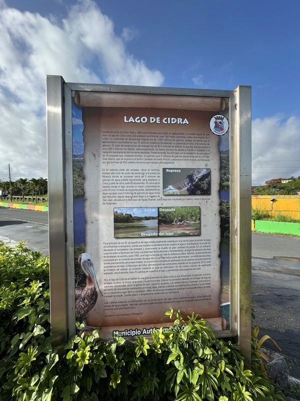
Lago de Cidra
Municipio Autónomo de Cidra
— [Cidra Lake - Autonomous Municipality of Cidra] —
Construido entre los años 1944 y 1945 como embalse para suplir de agua potable a la ciudad capital de San Juan, el lago de Cidra cubre una extensión teritorial de unas 300 millas cuadradas y tiene una longitud de 5 millas. Su capacidad de almacenaje original era de 1,800 millones de galones, aunque se estima que la sedimentación acumulada en sus 73 años de existencia ha reducido su capacidad en unos 216 millones de galones. El costo de construcción del embalse fue de $3.5 millones de dólares, lo que hoy día equivaldría a unos $48.5 millones de dólares, aproximadamente. Su fuente principal de abasto lo era el río Bayamón y la captación resultante de las montañas aledañas. Posteriormente, fue reforzado por a instalación de una tuberia de 30 pulgadas que, mediante bombeo, le inyectan unos 5 millones de galones diariamente del río La Plata. Esta tubería, que se origina en el sector Candelas del barrio Rincón y atraviesa el barrio Arenas, es impulsada por tres bombas de 450 caballos de fuerza que trabajan alternadamente.
En el extremo norte del embalse, ubica la hermosa represa que sirve de punto de extracción a la planta defiltración donde se procesan cerca de 5 millones de galones de agua potable diariamente, para abastecer a Cidra y parte de otros pueblos adyacentes. Es cerca de la represa donde el lago alcanza su mayor profundidad de unos 60 pies. A través de sus compuertas, diariamente se dejan escapar unos 5 millones de galones de agua cruda que discurren (aguas abajo) hasta llegar a la represa de San Juan, ubicada en el Municipio de Aguas Buenas, para luego ser impulsada por tubería hasta el Municipio de Guaynabo.
Para principio de los 90, la superficie del lago estaba totalmente cubierta por una densa capa de jacinto de agua (Eichornia crassipes), planta del embalse y ocasionando la muerte de gran cantidad de peces. En un esfuerzo conjunto entre el Municipio de Cidra y la Autoridad de Acueductos y Alcantarillados, se logró la remoción de miles de toneladas de jacinto y para 1995, ya el lago lucía una vez más su belleza aculfera. Además, la sedimentación provocada por la corriente del bombeo de agua del río La Plata redujo parte del embalse, convirtiendo esta área, donde precisamente ubica este mirador, en una enorme montaña de sedimento donde apenas se podía observar la existencia del lago. El Municipio de Cidra, aprovechando la condiciones creadas por la sequía de 2015, tomó la iniciativa de realizar un proyecto mediante el cual se removieron 55 mil metros cúbicos de sedimento
Hoy, el lago de Cidra es el hábitat de una gran diversidad de peces como lo son el tucunaré, el barbudo, la lobina, la tilapia, el pleco, la chopa caracolera y la pechicolorada. Este se ha convertido también en el hogar de algunas especies introducidas, como la gallina de palo (Iguana iguana) y el caimán blanco (Caiman crocodilus), así como de una extensa variedad de animales, aves, plantas y árboles que adornan su entorno y lo convierten en un espléndido lugar para la recreación. Miles de personas anaulmente paractican la pesca de orilla y de bote, navegan en kayak, "paddle board" o simplemente contemplan su hermosura.
Los cidreños estamos comprometidos con la conservación del lago como nuestra principal y única fuente de abasto de agua potable. Además, valoramos este hermoso recurso como lugar de recreación para el disfrute nosotros y de todo Puerto Rico.
¡Ayúdanos a Conservario y Protegerlo!
Built between 1944 and 1945 as a reservoir to supply drinking water to the capital city of San Juan, Cidra Lake covers a land area of about 300 square miles and is 5 miles long.
Built between 1944 and 1945 as a reservoir to supply drinking water to the capital city of San Juan,
Its original storage capacity was 1,800 million gallons, although it is estimated that accumulated sedimentation in its 73 years of existence has reduced its capacity by some 216 million gallons. The construction cost of the reservoir was $3.5 million dollars, which today would be equivalent to approximately $48.5 million dollars. Its main source of supply was the Bayamón River and the resulting intake from the surrounding mountains. Subsequently, it was reinforced by the installation of a 30-inch pipe that, through pumping, injects some 5 million gallons daily from the La Plata river. This pipeline, which originates in the Candelas sector of the Rincón neighborhood and crosses the Arenas neighborhood, is driven by three 450-horsepower pumps that work alternately.
At the northern end of the reservoir, there is a beautiful dam that serves as the extraction point for the filtration plant where about 5 million gallons of drinking water are processed daily to supply Cidra and part of other adjacent towns. It is near the dam that the lake reaches its deepest depth of about 60 feet. Through its gates, some 5 million gallons of raw water are let out daily and flow (downstream) until it reaches the San Juan dam, located in the Municipality of Aguas Buenas, to be later pumped by pipeline to the Municipality from Guaynabo.
By the early 1990s, the surface of the lake was completely covered by a dense layer of water hyacinth (Eichornia crassipes), a reservoir plant, causing the death of large numbers of fish. In a joint effort between the Municipality of Cidra and the Aqueduct and Sewer Authority, the removal of thousands of tons of hyacinth was achieved and by 1995, the lake once again showed off its aquifer beauty. In addition, the sedimentation caused by the current from the pumping of water from the La Plata River reduced part of the reservoir, turning this area, where this viewpoint is precisely located, into a huge mountain of sediment where the existence of the lake could barely be observed. The Municipality of Cidra, taking advantage of the conditions created by the 2015 drought, took the initiative to carry out a project through which 55,000 cubic meters of exposed sediment were removed, returning some 25 blocks of surface to the lake and allowing this spectacular view.
Today, Lake Cidra is the habitat of a great diversity of fish such as the tucunaré, the barbudo, the bass, the tilapia, the pleco, the snail and the red-breasted sunfish. This has also become the home of some introduced species, such as the hen of wood (Iguana iguana) and the white caiman (Caiman crocodilus), as well as a wide variety of animals, birds, plants and trees that adorn its environment and make it a splendid place for recreation. Thousands of people annually practice shore and boat fishing, kayaking, paddleboarding, or simply contemplate its beauty.
We Cidreños are committed to conserving the lake as our main and only source of drinking water supply. In addition, we value this beautiful resource as a place of recreation for the enjoyment of us and all of Puerto Rico.
Help us conserve and protect it!
Erected by Municipio de Cidra.
Topics. This historical marker is listed in these topic lists: Animals • Environment • Natural Resources • Parks & Recreational Areas • Waterways & Vessels. A significant historical year for this entry is 1944.
Location. 18° 10.58′ N, 66° 9.033′ W. Marker is in Cidra in Municipio de Cidra, Puerto Rico. It is in Arenas. Marker is on Calle Antonio R. Barcelo (Puerto Rico Route 172) 0.2 kilometers Carraterra Río Abajo (Puerto Rico Route 172). Touch for map. Marker is at or near this postal address: Calle Antonio R Barcelo 13, Cidra PR 00739, United States of America. Touch for directions.
Other nearby markers. At least 8 other markers are within 8 kilometers of this marker, measured as the crow flies. Tucunar / Chopa (here, next to this marker); Reconocimiento al Veterano Cidreño (approx. 1.1 kilometers away); En Honor al Peon Caminero (approx. 6.8 kilometers away); "El Pan Nuestro" (approx. 7.2 kilometers away); Fundación de la Ciudad (approx. 7.2 kilometers away); Hallazgos Arqueológicos (approx. 7.3 kilometers away); Jesús Ríos Robles (approx. 7.3 kilometers away); Réplicas de Osamentas de Niños y Familias (approx. 7.3 kilometers away). Touch for a list and map of all markers in Cidra.
Credits. This page was last revised on December 18, 2023. It was originally submitted on June 8, 2023, by Devry Becker Jones of Washington, District of Columbia. This page has been viewed 284 times since then and 116 times this year. Photos: 1, 2, 3. submitted on June 8, 2023, by Devry Becker Jones of Washington, District of Columbia.


