Silver Springs in Marion County, Florida — The American South (South Atlantic)
Silver Springs’ People
Silver Springs State Park
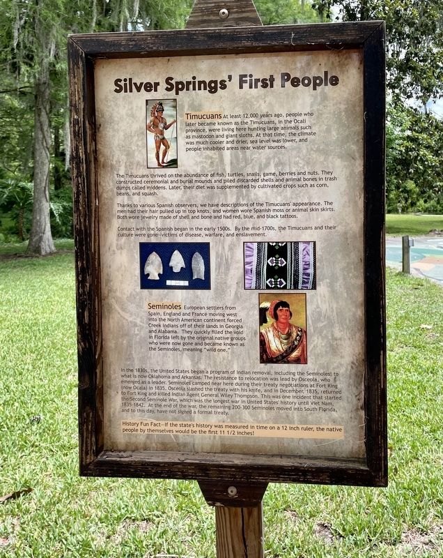
The Timucuans thrived on the abundance of fish, turtles, snails, game, berries and nuts. They constructed ceremonial and burial mounds and piled discarded shells and animal bones in trash dumps called midden. Later, their diet was supplemented by cultivated crops such as corn, beans, and squash.
Thanks to various Spanish observers, we have descriptions of the Timucuans' appearance. The men had their hair pulled up in top knots, and women wore Spanish moss or animal skin skirts. Both wore jewelry made of shell and bone and had red, blue, and black tattoos.
Contact with the Spanish began in the early 1500s. By the mid-1700s, the Timucuans and their culture were gone-victims of disease, warfare, and enslavement.
Seminoles European settlers from Spain, England and France moving west into the North American continent forced Creek Indians off of their lands in Georgia and Alabama. They quickly filled the void in Florida left by the original native groups who were now gone and became known as the Seminoles, meaning "wild one.”
In the 1830s, the United States began a program of Indian removal, including the Seminoles; to what is now Oklahoma and Arkansas. The resistance to relocation was lead by Osceola, who emerged as a leader. Seminoles camped near here during their treaty negotiations at Fort King (now Ocala) in 1835. Osceola slashed the treaty with his knife, and in December, 1835, returned to Fort King and killed Indian Agent General Wiley Thompson. This was one incident that started the Second Seminole War, which was the longest war in United States' history until Viet Nam, 1835-1842. At the end of the war, the remaining 200-300 Seminoles moved into South Florida, and to this day, have not signed a formal treaty.
History Fun Fact—If the state's history was measured in time on a 12 inch ruler, the native people by themselves would be the first 11 1/2 inches!
Erected by Silver Springs State Park.
Topics. This historical marker is listed in these topic lists: Exploration • Native Americans • Parks & Recreational Areas • Settlements & Settlers • Wars, US Indian.
Location. 29° 13.057′ N, 82° 3.178′ W. Marker is in Silver Springs, Florida, in Marion County. Marker can be reached from the intersection of East Silver Springs Boulevard (Florida Route 40) and NE 57th Avenue, on the right when traveling east. This marker is located within Silver Springs State Park. Touch for map. Marker is at or near this postal address: 5656 E Silver Springs Blvd, Silver Springs FL 34488, United States of America. Touch for directions.
Other nearby markers. At least 8 other markers are within walking distance of this marker. Postcards from the Past (within shouting distance of this marker); The Creature (about 300 feet away, measured in a direct line); From Disaster to Award-Winning Design (about 400 feet away); Florida’s Springs: Our Precious Resource (about 400 feet away); Sea Hunt (about 500 feet away); Silver Springs Paradise Park (about 600 feet away); Osceola (about 700 feet away); Florida’s Roadside Attractions (approx. 0.2 miles away). Touch for a list and map of all markers in Silver Springs.
Also see . . .
1. The Timucua: North Florida’s Early People. (Submitted on June 12, 2023, by Brandon D Cross of Flagler Beach, Florida.)
2. Silver Springs State Park: Famous spring plus cabins, hiking, history. (Submitted on June 12, 2023, by Brandon D Cross of Flagler Beach, Florida.)
Credits. This page was last revised on June 14, 2023. It was originally submitted on June 12, 2023, by Brandon D Cross of Flagler Beach, Florida. This page has been viewed 62 times since then and 20 times this year. Photos: 1, 2. submitted on June 12, 2023, by Brandon D Cross of Flagler Beach, Florida. • Bernard Fisher was the editor who published this page.

