Herring Run Park in Baltimore, Maryland — The American Northeast (Mid-Atlantic)
Columbus Obelisk
June 11, 2023
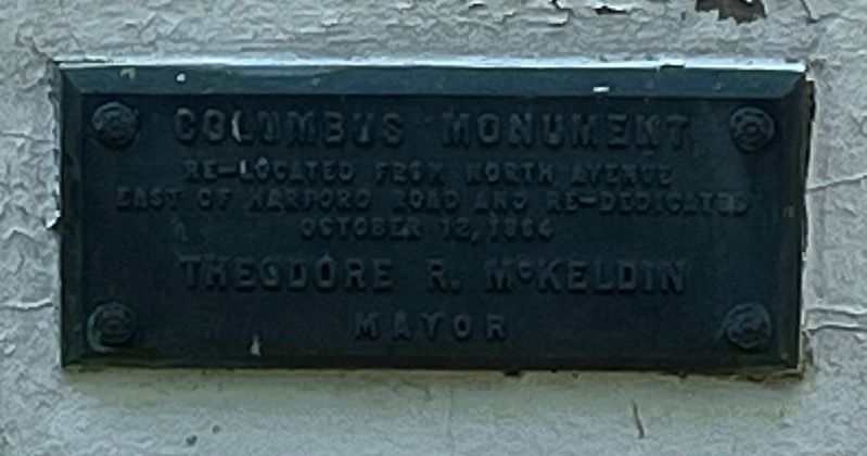
1. Columbus Obelisk plaque that remains on the marker
[Original inscription, since destroyed:]
Octob. XII MDCCVIIIC
[1964 plaque, which remains on the memorial:]
Erected 1792 by City of Baltimore, artist unknown.
Topics. This historical marker is listed in these topic lists: Arts, Letters, Music • Colonial Era • Exploration • Waterways & Vessels. A significant historical date for this entry is October 12, 1492.
Location. 39° 20.18′ N, 76° 34.473′ W. Marker is in Baltimore, Maryland. It is in Herring Run Park. It is on Harford Road (Maryland Route 147) south of Parkside Drive, on the right when traveling north. Touch for map. Marker is at or near this postal address: 4100 Harford Rd, Baltimore MD 21214, United States of America. Touch for directions.

Regionally, this marker is in Central Maryland. It is also in the American Mid-Atlantic, in the Chesapeake Bay Region, and on the Eastern Seaboard. Globally, it is in the North Atlantic Region, North America, the Western Hemisphere, the Western World, and the Anglosphere.
this page online
Other nearby markers. At least 8 other markers are within walking distance of this marker: Eutaw Manor & the Heritage Trail (approx. 0.2 miles away); Morgan Park & Recreation During Segregation (approx. 0.3 miles away); Emeline Jones: Renowned Chef of the 1800's (approx. 0.4 miles away); A Champion: a Survivor of Dutch Elm Disease (approx. 0.4 miles away); Estates Divide Creating Herring Run Park (approx. half a mile away); 11,000 Year Old Campsite Along Heritage Trail (approx. half a mile away); Morgan Park (approx. 0.7 miles away); a different marker also named Morgan Park (approx. 0.7 miles away). Touch for a list and map of all markers in Baltimore.
Another marker is no longer nearby. Eutaw Manor (was approx. 0.4 miles away but has been permanently removed).
Also see . . . Columbus Obelisk (Wikipedia article). This article explains the controversies surrounding the memorial. (Submitted on June 18, 2023, by Devry Becker Jones of Washington, District of Columbia.)

June 11, 2023
2. The Columbus Obelisk
Credits. This page was last revised on February 13, 2026. It was originally submitted on June 18, 2023. This page has been viewed 408 times since then and 51 times this year. Photos: 1, 2. submitted on June 18, 2023.
