Old Saybrook Center in Middlesex County, Connecticut — The American Northeast (New England)
Adriaen Block & New Netherland
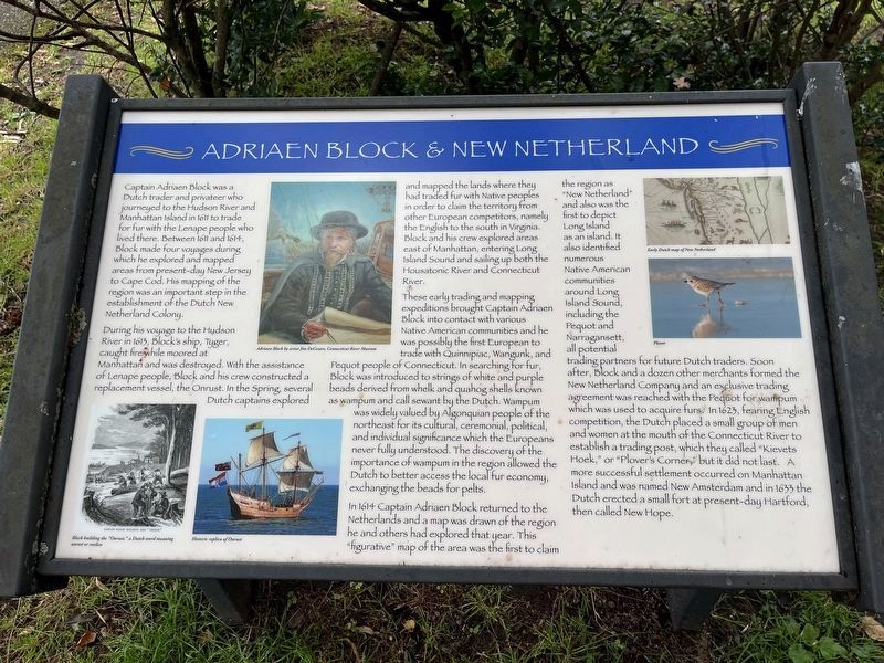
Captain Adriaen Block was a Dutch trader and privateer who journeyed to the Hudson River and Manhattan Island in 1611 to trade for fur with the Lenape people who lived there. Between 1611 and 1614, Block made four voyages during which he explored and mapped areas from present-day New Jersey to Cape Cod. His mapping of the region was an important step in the establishment of the Dutch New Netherland Colony.
During his voyage to the Hudson River in 1613, Block's ship, Tyger, caught fire while moored at Manhattan and was destroyed. With the assistance of Lenape people, Block and his crew constructed a replacement vessel, the Onrust. In the Spring, several Dutch captains explored and mapped the lands where they had traded fur with Native peoples in order to claim the territory from other European competitors, namely the English to the south in Virginia. Block and his crew explored areas east of Manhattan, entering Long Island Sound and sailing up both the Housatonic River and Connecticut River.
These early trading and mapping expeditions brought Captain Adriaen Block into contact with various Native American communities and he was possibly the first European to trade with Quinnipiac, Wangunk, and Pequot people of Connecticut. In searching for fur, Block was introduced to strings of white and purple beads derived from whelk and quahog shells known as wampum and called sewant by the Dutch. Wampum was widely valued by Algonquian people of the northeast for its cultural, ceremonial, political, and individual significance which the Europeans never fully understood. The discovery of the importance of wampum in the region allowed the Dutch to better access the local fur economy, exchanging the beads for pelts.
In 1614 Captain Adriaen Block returned to the Netherlands and a map was drawn of the region and he and others had explored that year. This "figurative" map of the area was the first to claim the region as "New Netherland" and also was the first to depict Long Island as an island. It also identified numerous Native American communities around Long Island Sound, including the Pequot and Narragansett, all potential trading partners for future Dutch traders. Soon after, Block and a dozen other merchants formed the New Netherland Company and an exclusive trading agreement was reached with the Pequot for wampum which was used to acquire furs. In 1623, fearing English competition, the Dutch placed a small group of men and women at the mouth of the Connecticut River to establish a trading post, which they called "Kievets Hoek," or "Plover's Corner," but it did not last. A more successful settlement occurred on Manhattan Island and was named New Amsterdam and in 1633 the Dutch erected
Topics. This historical marker is listed in these topic lists: Colonial Era • Industry & Commerce • Native Americans • Settlements & Settlers • Waterways & Vessels. A significant historical year for this entry is 1611.
Location. 41° 17.079′ N, 72° 21.109′ W. Marker is in Old Saybrook, Connecticut, in Middlesex County. It is in Old Saybrook Center. Marker is on College Street (Connecticut Route 154) just west of Bridge Street (Connecticut Route 154), on the right when traveling west. The marker stands on the grounds of Fort Saybrook Monument Park. Touch for map. Marker is at or near this postal address: 115 College Street, Old Saybrook CT 06475, United States of America. Touch for directions.
Other nearby markers. At least 8 other markers are within walking distance of this marker. Fishing on the Connecticut (a few steps from this marker); The Saybrook Bar (a few steps from this marker); Welcome to Fort Saybrook (a few steps from this marker); Battlefields of the Pequot War (a few steps from this marker); The Connecticut River (within shouting distance of this marker); The Connecticut Valley Railroad (within shouting distance of this marker); Connecticut Valley Railroad Roundhouse & Turntable Site (within shouting distance of this marker); Fort Saybrook – 1635 (within shouting distance of this marker). Touch for a list and map of all markers in Old Saybrook.
Related marker. Click here for another marker that is related to this marker. This marker has replaced the linked marker.
Credits. This page was last revised on October 4, 2023. It was originally submitted on July 1, 2023, by Devry Becker Jones of Washington, District of Columbia. This page has been viewed 92 times since then and 31 times this year. Photos: 1, 2. submitted on July 1, 2023, by Devry Becker Jones of Washington, District of Columbia.

