Sherwood Island State Park in Westport in Fairfield County, Connecticut — The American Northeast (New England)
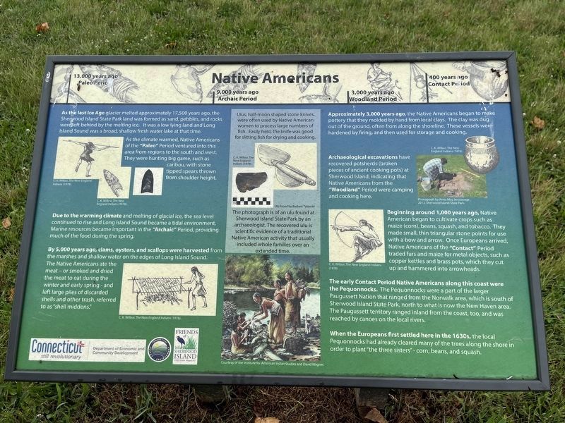
Native Americans
13,000 years ago: Paleo Period
9,000 years ago: Archaic Period
3,000 years ago: Woodland Period
400 years ago: Contact Period
As the last Ice Age glacier melted approximately 17,500 years ago the Sherwood Island State Park land was formed as sand, pebbles, and rocks were left behind by the melting ice. It was a low lying land and Long Island Sound was a broad, shallow fresh water lake at that time.
As the climate warmed, Native Americans of the "Paleo" Period ventured into this area from regions to the south and west. They were hunting big game, such as caribou, with stone tipped spears thrown from shoulder height.
Due to the warming climate and melting of glacial ice, the sea level continued to rise and Long Island Sound became a tidal environment. Marine resources became important in the "Archaic" Period, providing much of the food during the spring.
By 5,000 years ago, clams, oysters, and scallops were harvested from the marshes and shallow water on the edges of Long Island Sound. The Native Americans ate the meat — or smoked and dried the meat to eat during the winter and early spring — and left large piles of discarded shells and other trash, referred to as "shell middens."
Approximately 3,000 years ago, the Native Americans began to make pottery that they molded by hand from local clays. The clay was dug out of the ground, often from along the shoreline. These vessels were hardened by firing, and then used for storage and cooking.
Archaeological excavations have recovered potsherds (broken pieces of ancient cooking pots) at Sherwood Island, indicating that Native Americans from the "Woodland" Period were camping and cooking here.
Beginning around 1,000 years ago, Native American began to cultivate crops such as maize (corn), beans, squash, and tobacco. they made small, thin triangular stone points for use with a bow and arrow. Once Europeans arrived, Native Americans of the "Contact" Period traded furs and maize for metal objects, such as copper kettles and brass pots, which they cut up and hammered into arrowheads.
The early Contact Period Native Americans along this coast were the Pequonnocks. The Pequonnocks were a part of the larger Paugussett Nation that ranged from the Norwalk area, which is south of Sherwood Island State Park, north to what is now the New Haven area. The Paugussett territory ranged inland from the coast, too, and was reached by canoes on the local rivers.
When the Europeans first settled here in the 1630s, the local Pequonnocks had already
[Caption:]
Ulus, half-moon shaped stone knives, were used by Native American women to process large numbers of fish. Easily held, the knife was good for slitting fish for drying and cooking.
The photograph is of an ulu found at Sherwood island State Park by an archaeologist. The recovered ulu is scientific evidence of a traditional Native American activity that usually included whole families over an extended time.
Erected by Connecticut Department of Economic and Community Development; Connecicut Department of Energy and Environment; Friends of Sherwood Island.
Topics. This historical marker is listed in these topic lists: Agriculture • Anthropology & Archaeology • Native Americans • Settlements & Settlers.
Location. 41° 6.703′ N, 73° 19.891′ W. Marker is in Westport, Connecticut, in Fairfield County. It is in Sherwood Island State Park. Marker is on Sherwood Island Connector (County Road 476) one mile south of Connecticut Turnpike (Interstate 95), on the right when traveling south. Touch for map. Marker is in this post office area: Westport CT 06880, United States of America. Touch for directions.
Other nearby markers. At least 8 other markers are within 3 miles of this marker, measured as the crow flies. Sherwood Island 9.11.01 Memorial / Connecticut's 9.11.01 Living Memorial (within shouting distance of this marker); Impressionism in Connecticut (about 600 feet away, measured in a direct line); Minuteman (approx. 1.2 miles away); Battle of Westport Commemoration (approx. 1.3 miles away); Greens Farms Meeting House (approx. 1.7 miles away); Nash House (approx. 1.7 miles away); First Engagement (approx. 2.3 miles away); Compo Beach (approx. 2.3 miles away). Touch for a list and map of all markers in Westport.
Credits. This page was last revised on March 27, 2024. It was originally submitted on July 1, 2023, by Devry Becker Jones of Washington, District of Columbia. This page has been viewed 64 times since then and 22 times this year. Photos: 1, 2. submitted on July 1, 2023, by Devry Becker Jones of Washington, District of Columbia.

