Near Monroe in Monroe County, Michigan — The American Midwest (Great Lakes)
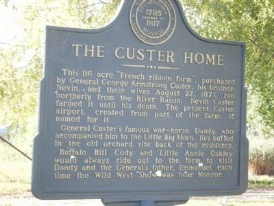
The Custer Home
General Custer's famous war-horse, Dandy, who accompanied him to the Little Big Horn, lies buried in the old orchard site back of the residence.
Buffalo Bill Cody and Little Annie Oakley would always ride out to the farm to visit Dandy and the General's father, Emmanuel, each time the Wild West Show was near Monroe.
Erected by Monroe County Historical Society.
Topics. This historical marker is listed in these topic lists: Agriculture • Animals • Settlements & Settlers. A significant historical year for this entry is 1871.
Location. 41° 55.772′ N, 83° 26.612′ W. Marker is near Monroe, Michigan, in Monroe County. Marker is on Custer Road, on the right when traveling west. Touch for map. Marker is in this post office area: Monroe MI 48162, United States of America. Touch for directions.
Other nearby markers. At least 8 other markers are within 2 miles of this marker, measured as the crow flies. St. Antoine, Riviere Aux Raisins / "The Cross Leads Generations On" (approx. 0.7 miles away); Deloeuil Blacksmith Shop (approx. ¾ mile away); Edward D. Ellis (approx. 0.9 miles away); The Edward D. Ellis Building (approx. one mile away); Navarre - Anderson Trading Post (approx. one mile away); a different marker also named The Navarre - Anderson Trading Post (approx. one mile away); McDowell Papermill / Papermill School (approx. one mile away); Waterloo Dam (approx. 1.3 miles away). Touch for a list and map of all markers in Monroe.
Credits. This page was last revised on November 23, 2019. It was originally submitted on September 25, 2009, by James D. Harvey of Seville,, Ohio. This page has been viewed 3,709 times since then and 331 times this year. Photo 1. submitted on September 25, 2009, by James D. Harvey of Seville,, Ohio. • Kevin W. was the editor who published this page.
Editor’s want-list for this marker. A clear, close up photo of the marker. • Wide area view of the marker and its surroundings. • Can you help?
