
Roswell in Fulton County, Georgia — The American South (South Atlantic)
The History of Vickery Creek and the Covered Bridge
| — | Old Mill Park | — |
Photographed by Tom Bosse, July 3, 2023
1. The History of Vickery Creek and the Covered Bridge Marker
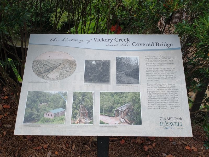
For over 140 years, the creek was the site of numerous mills in the Roswell area: Lebanon Mills (located north of Holcomb Bridge), a flour mill and the Ivy/Laurel Mills (located further downstream at the confluence of Vickery Creek and the Chattahoochee River) and three cotton mills on this site.
The covered bridge directly ahead was built by the City of Roswell to connect Old Mill Park with the Vickery Creek Unit of the Chattahoochee River National Recreation Area. Former councilmember Sally White first proposed a pedestrian bridge over the creek. Mayor Jere Wood suggested it be constructed of wood and roofed in the “covered bridge tradition”. The bridge was fabricated in Oregon of Douglas fir and assembled on-site in two sections. A large mobile crane was used to set the bridge place. The bridge was dedicated on September 22, 2004.
(captions)
Roswell in the rough. First view of Mr. Roswell King near “Lover’s Rock” (1835). Sketch by Henry Merrell
Courtesy of Georgia Archives, Archibald Smith Family Papers, oc 1988-0012
Lover’s Rock on Vickery Creek, ca. 1900
Courtesy of the Roswell Historical Society, McNeely Family Visual Arts Collection
Crossing at Vickery Creek, ca. 1900
Courtesy of the Roswell Historical Society, King, Baker, and Simpson Families Papers
Covered Bridge Construction, 2004
Courtesy of the City of Roswell, Recreation and Parks Department
Covered Bridge Construction, 2004
Courtesy of the City of Roswell, Recreation and Parks Department
Covered Bridge Construction, 2004
Courtesy of the City of Roswell, Recreation and Parks Department
Topics and series.
this page online
Location. 34° 0.799′ N, 84° 21.545′ W. Marker is in Roswell, Georgia, in Fulton County. It can be reached from Mill Street 0.3 miles east of Atlanta Street, on the right when traveling south. Located on the Vickery Creek Park Trail. Touch for map. Marker is at or near this postal address: 95 Mill St, Roswell GA 30075, United States of America. Touch for directions.

Regionally, this marker is in Georgia’s Piedmont and in Metro Atlanta. It is also in the American South and specifically in the Deep South. Globally, it is in North America, the Western Hemisphere, the Western World, and the Anglosphere. Historically, it finds itself in what was once the territory of the Mississippian Culture, one of the original Thirteen Colonies, one of the Confederate States of America, and the Antebellum South.
Other nearby markers. At least

Photographed by Tom Bosse, July 3, 2023
2. The History of Vickery Creek and the Covered Bridge Marker
Marker is to the left of the covered bridge.

Photographed by Tom Bosse, July 3, 2023
3. The History of Vickery Creek and the Covered Bridge Marker

Photographed by Tom Bosse, July 3, 2023
4. Vickery Creek Covered Bridge
Credits. This page was last revised on July 11, 2023. It was originally submitted on July 10, 2023, by Tom Bosse of Jefferson City, Tennessee. This page has been viewed 880 times since then and 75 times this year. Photos: 1, 2, 3, 4. submitted on July 10, 2023, by Tom Bosse of Jefferson City, Tennessee. • Bernard Fisher was the editor who published this page.
