Greenfield in Franklin County, Massachusetts — The American Northeast (New England)
River Works Park
above and underneath
| — | Town of Greenfield, Massachusetts | — |
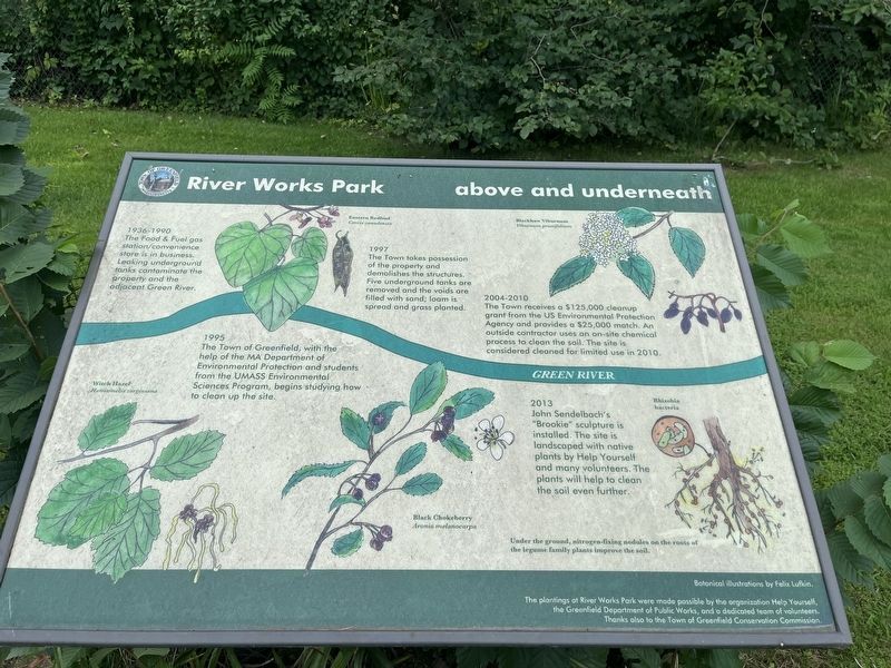
1936 - 1990
The Food & Fuel gas station/convenience store is in business. Leaking underground tanks contaminate the property and the adjacent Green River.
1995
The Town of Greenfield, with the help of the MA Department of Environmental Protection and students from the UMASS Environmental Sciences Program, begins studying how to clean up the site.
1997
The Town takes possession of the property and demolishes the structures. Five underground tanks are removed and the voids are filled with sand; loam is spread and grass planted.
2004 - 2010
The Town receives a $125,000 cleanup grant from the US Environmental Protection Agency and provides a $25,000 match. an outside contractor uses an on-site chemical process to clean the soil. The site is considered cleaned for limited use in 2010.
2013
John Sendelbach's "Brookie" sculpture is installed. The site is landscaped with native plants by Help Yourself and many volunteers. The plants will help to clean the soil even further.
Erected by Town of Greenfield, Massachusetts.
Topics. This historical marker is listed in these topic lists: Arts, Letters, Music
this page online
Location. 42° 34.702′ N, 72° 35.914′ W. Marker is in Greenfield, Massachusetts, in Franklin County. It is on Deerfield Street (U.S. 5) north of Washington Street, on the left when traveling north. Touch for map. Marker is at or near this postal address: 250 Deerfield Street, Greenfield MA 01301, United States of America. Touch for directions.

Regionally, this marker is in Pioneer Valley. It is also in the American Northeast and in New England. Globally, it is in North America, the Western Hemisphere, the Western World, and the Anglosphere. Historically, it finds itself in what was once one of the original Thirteen Colonies.
Other nearby markers. At least 8 other markers are within walking distance of this marker: A different marker also named River Works Park (a few steps from this marker); a different marker also named River Works Park (a few steps from this marker); J. Russell Cutlery & Gtd (about 800 feet away, measured in a direct line); Masonic Hall (approx. 0.6 miles away); U.S. Post Office
Credits. This page was last revised on August 13, 2023. It was originally submitted on August 13, 2023, by Devry Becker Jones of Washington, District of Columbia. This page has been viewed 185 times since then and 15 times this year. Photos: 1, 2. submitted on August 13, 2023, by Devry Becker Jones of Washington, District of Columbia.
