William O'Brien State Park near Marine on St. Croix in Washington County, Minnesota — The American Midwest (Upper Plains)
Native Cultures and the River
— Riverside Trail —
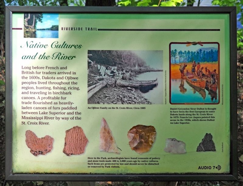
Long before French and British fur traders arrived in the 1600s, Dakota and Ojibwe peoples lived throughout the region, hunting, fishing, ricing, and traveling in birchbark canoes. A profitable fur trade flourished as heavily-laden canoes of furs paddled between Lake Superior and the Mississippi River by way of the St. Croix River.
An Ojibwe Family on the St. Croix River, Circa 1885
Here in the Park, archaeologists have found remnants of pottery and stone tools made 400 to 3,000 years ago by native cultures. Such items are protected by law and should never be disturbed or removed by Park visitors.
Daniel Greysolon Sieur Dulhut is thought to have been the first European to enter Dakota lands along the St. Croix River in 1679. Francis Lee Jacques painted this scene in the 1920s, which shows Dulhut on Lake Superior.
Erected by Minnesota Department of Natural Resources.
Topics. This historical marker is listed in these topic lists: Anthropology & Archaeology • Industry & Commerce • Native Americans • Waterways & Vessels. A significant historical year for this entry is 1679.
Location. 45° 13.542′ N, 92° 45.413′ W. Marker is near Marine on St. Croix, Minnesota, in Washington County . It is in William O'Brien State Park. Marker can be reached from O'Brien Trail N. (County Route 33) east of Minnesota Route 95. The marker is on the Riverside Trail near the north end of the segment along the St. Croix River. Touch for map. Marker is in this post office area: Scandia MN 55073, United States of America. Touch for directions.
Other nearby markers. At least 8 other markers are within 2 miles of this marker, measured as the crow flies. White Pines (approx. 0.2 miles away); Lake Alice (approx. 0.2 miles away); William O'Brien State Park (approx. 0.4 miles away); Wedge Hill (approx. 0.6 miles away); The Marine Township Hall (approx. 1.9 miles away); Historic Marine on St. Croix (approx. 2 miles away); St. Croix National Scenic Riverway (approx. 2 miles away); Technological Revolution (approx. 2 miles away). Touch for a list and map of all markers in Marine on St. Croix.
Credits. This page was last revised on September 4, 2023. It was originally submitted on September 4, 2023, by McGhiever of Minneapolis, Minnesota. This page has been viewed 52 times since then and 9 times this year. Photos: 1, 2. submitted on September 4, 2023, by McGhiever of Minneapolis, Minnesota. • J. Makali Bruton was the editor who published this page.

