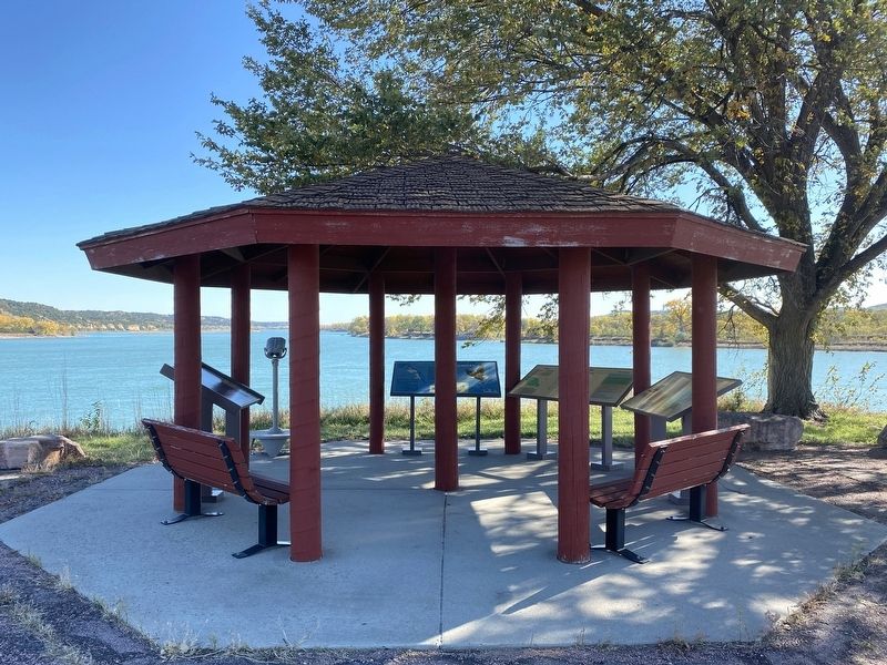
White Swan Township near Pickstown in Charles Mix County, South Dakota — The American Midwest (Upper Plains)
Missouri River
Basin
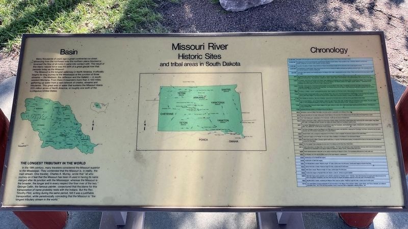
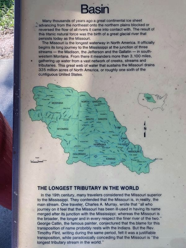
Many thousands of years ago a great continental ice sheet advancing from the northeast onto the northern plains blocked or reversed the flow of all rivers it came into contact with. The result of this titanic natural force was the birth of a great glacial river that persists today as the Missouri.
The Missouri is the longest waterway in North America. It officially begins its long journey to the Mississippi at the junction of three streams — the Madison, the Jefferson and the Gallatin — in southwestern Montana. From there it meanders more than 3,100 miles, gathering up water from a vast network of creeks, streams and tributaries. This great web of water that sustains the Missouri drains 335 million acres of North America, or roughly one sixth of the contiguous United States.
[map of Missouri River Basin]
The Longest Tributary in the World
In the 19th century, many travelers considered the Missouri superior to the Mississippi. They contended that the Missouri is, in reality, the main stream. One traveler, Charles A. Murray, wrote that "all who journey on it feel that the Missouri has been ill-used in having its name merged after its junction with the Mississippi; whereas the Missouri is the broader, the longer and in every respect the finer river of the two." George Catlin, the famous painter, conjectured that the blame for this transposition of name probably rests with the Indians. But the Rev. Timothy Flint, writing during the same period, felt it was a justifiable transposition, while paradoxically conceding that the Missouri is "the longest tributary stream in the world."
Historic Sites
and tribal areas in South Dakota
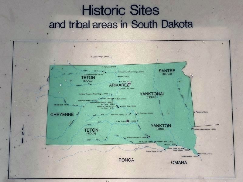
[map of South Dakota]
Chronology
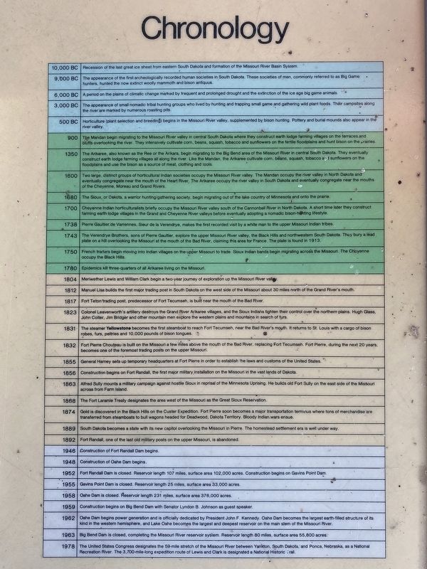
10,000 BC | Recession of the last great ice sheet from eastern South Dakota and formation of the Missouri River Basin System.
9,000 BC | The appearance of the first archeologically recorded human societies in South Dakota. These societies of men, commonly referred to as Big Game hunters, hunted the now extinct woolly mammoth and bison antiquus.
6,000 BC | A period on the plains of climatic change marked by frequent and prolonged drought and the extinction of the ice age big game animals.
3,000 BC | The appearance of small nomadic tribal hunting groups who lived by hunting and trapping small game and gathering wild plant foods. Their campsites along the river are marked by numerous roasting pits.
500 BC | Horticulture (plant selection and breeding) begins in the Missouri River valley, supplemented by bison hunting. Pottery and burial mounds also appear in the river valley.
900 | The Mandan begin migrating to the Missouri River valley in central South Dakota where they construct earth lodge farming villages on the terraces and bluffs overlooking the river. They intensively cultivate corn, beans, squash, tobacco and sunflowers on the fertile floodplains and hunt bison on the prairies.
1350 | The Arikaree, also known as the Ree or the Arikara, begin migrating to the Big Bend area of the Missouri River in central South Dakota. They eventually construct earth lodge farming villages all along the river. Like the Mandan, the Arikaree cultivate corn, beans, squash, tobacco and sunflowers on the floodplains and use the bison as a source of meat, clothing and tools.
1600 | Two large, distinct groups of horticultural Indian societies occupy the Missouri River valley. The Mandan occupy the river valley in North Dakota and eventually congregate near the mouth of the Heart River. The Arikaree occupy the river valley in South Dakota and eventually congregate near the mouths of the Cheyenne, Moreau and Grand Rivers.
1680 | The Sioux, or Dakota, a warrior hunting/gathering society, begin migrating out of the lake country of Minnesota and onto the prairie.
1700 | Cheyenne Indian horticulturalists briefly occupy the Missouri River valley south of the Cannonball River in North Dakota. A short time later they construct farming earth lodge villages in the Grand and Cheyenne River valleys before eventually adopting a nomadic bison-hunting lifestyle.
1738 | Pierre Gaultier de Varrennes, Sieur de la Verendrye, makes the first recorded visit by a white man to the upper Missouri Indian tribes.
1743 | The Verendrye Brothers, sons of Pierre Gaultier, explore the upper Missouri River valley, the Black Hills and northwestern South Dakota. They bury a lead plate on a hill overlooking the Missouri at the mouth of the Bad River, claiming this area for France. The plate is found in 1913.
1750 | French traders begin moving into Indian villages on the upper Missouri to trade. Sioux Indian bands begin migrating across the Missouri. The Cheyenne occupy the Black Hills.
1780 | Epidemics kill three-quarters of all Arikaree living on the Missouri.
1804 | Meriwether Lewis and William Clark begin a two-year journey of exploration up the Missouri River valley.
1812 | Manuel Lisa builds the first major trading post in South Dakota on the west side of the Missouri about 30 miles north of the Grand River's mouth.
1817 | Fort Teton trading post, predecessor of Fort Tecumseh, is built near the mouth of the Bad River.
1823 | Colonel Leavenworth's artillery destroys the Grand River Arikaree villages, and the Sioux Indians tighten their control over the northern plains. Hugh Glass, John Colter, Jim Bridger and other mountain men explore the western plains and mountains in search of furs.
1831 | The steamer Yellowstone becomes the first steamboat to reach Fort Tecumseh, near the Bad River's mouth. It returns to St. Louis with a cargo of bison robes, furs, peltries and 10,000 pounds of bison tongues.
1832 | Fort Pierre Chouteau is built on the Missouri a few miles above the mouth of the Bad River, replacing Fort Tecumseh. Fort Pierre, during the next 20 years, becomes one of the foremost trading posts on the upper Missouri.
1855 | General Harney sets up temporary headquarters at Fort Pierre in order to establish the laws and customs of the United States.
1856 | Construction begins on Fort Randall, the first major military installation on the Missouri in the vast lands of Dakota.
1863 | Alfred Sully mounts a military campaign against hostile Sioux in reprisal of the Minnesota Uprising. He builds old Fort Sully on the east side of the Missouri across from Farm Island.
1868 | The Fort Laramie Treaty designates the area west of the Missouri as the Great Sioux Reservation.
1874 | Gold is discovered in the Black Hills on the Custer Expedition. Fort Pierre soon becomes a major transportation terminus where tons of merchandise are transferred from steamboats to bull wagons headed for Deadwood, Dakota Territory. Bloody Indian wars ensue.
1889 | South Dakota becomes a state with its new capitol overlooking the Missouri in Pierre. The homestead settlement era is well under way.
1892 | Fort Randall, one of the last old military posts on the upper Missouri, is abandoned.
1946 | Construction of Fort Randall Dam begins.
1948 | Construction of Oahe Dam begins.
1952 | Fort Randall Dam is closed. Reservoir length 107 miles, surface area 102,000 acres. Construction begins on Gavins Point Dam.
1955 | Gavins Point Dam is closed. Reservoir length 25 miles, surface area 33,000 acres.
1958 | Oahe Dam is closed. Reservoir length 231 miles, surface area 376,000 acres.
1959 | Construction begins on Big Bend Dam with Senator Lyndon B. Johnson as guest speaker.
1962 | Oahe Dam begins power generation and is officially dedicated by President John F. Kennedy. Oahe Dam becomes the largest earth-filled structure of its kind in the western hemisphere, and Lake Oahe becomes the largest and deepest reservoir on the main stem of the Missouri River.
1963 | Big Bend Dam is closed, completing the Missouri River reservoir system. Reservoir length 80 miles, surface area 55,800 acres.
1978 | The United States Congress designates the 59-mile stretch of the Missouri River between Yankton, South Dakota, and Ponca, Nebraska, as a National Recreation River. The 3,700-mile-long expedition route of Lewis and Clark is designated a National Historic Trail.
Topics. This historical marker is listed in these topic lists: Environment • Forts and Castles • Native Americans • Waterways & Vessels. A significant historical year for this entry is 1350.
Location. 43° 3.342′ N, 98° 32.997′ W. Marker is near Pickstown, South Dakota, in Charles Mix County. It is in White Swan Township. Located at the interpretive shelter above the fishing area at the Fort Randall Dam. Touch for map. Marker is in this post office area: Lake Andes SD 57356, United States of America. Touch for directions.
Other nearby markers. At least 8 other markers are within walking distance of this marker. A Gathering Place for Eagles (here, next to this marker); Fort Randall Area (here, next to this marker); Fort Randall Eagle Roost (a few steps from this marker); Welcome to Randall Creek Recreation Area (approx. 0.3 miles away); Supply & Demand (approx. 0.6 miles away); Frontier Firepower (approx. 0.6 miles away); Crime & Punishment (approx. 0.6 miles away); In Sickness & in Health (approx. 0.6 miles away). Touch for a list and map of all markers in Pickstown.
Related marker. Click here for another marker that is related to this marker.
Credits. This page was last revised on October 25, 2023. It was originally submitted on October 25, 2023. This page has been viewed 51 times since then and 7 times this year. Photos: 1, 2, 3, 4, 5. submitted on October 25, 2023.
