Central Office District in Richmond, Virginia — The American South (Mid-Atlantic)
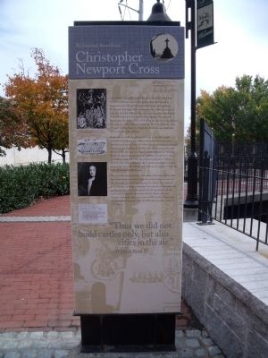
Christopher Newport Cross / Canal Walk
Richmond Riverfront
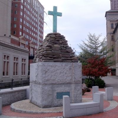
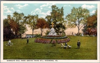
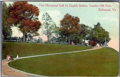
On May 24, 1607, Captain Christopher Newport and a party of explorers who had landed at Jamestown just days earlier arrived at the site of modern-day Richmond. Hoping to find a passage to the Pacific, they found instead a fortified Indian village with outlying agricultural fields. Newport, advised by the leader of the village not to proceed farther than the falls, where a rival group of Indians lived, traveled the next day a short distance upstream. There he planted a cross in honor of King James I of England, probably on a small islet not too far from the fall line.
In the decades following Newport’s visit to the falls, steady inroads by Europeans into Indian territories led to numerous hostilities and several wars. In 1646, a treaty gave much of eastern Virginia to the English, and by the early 18th century, the land along the falls was part of a large plantation owned by William Byrd, the region’s most prominent trader in furs, tobacco, rum, and African slaves. In 1705, the plantation passed to William Byrd II, who, when pressed by the Colonial assembly to set up a town at the site of his trading post, laid out 34 squares of four lots each, thus founding Richmond.
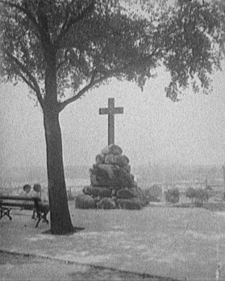
The natural beauty, resources, and power of the James River falls have drawn humans to live beside them since time immemorial. It is no surprise that this was among the earliest sites explored by Europeans, and that settlement here played an important role in Colonial America. In recognition of the significance of the area’s early history, the Association for the Preservation of Virginia Antiquities erected a cross in 1907, on the tercentenary of Christopher Newport’s visit. In 2000, the cross was moved to 12th Street.
“Thus we did not build castles only, but also cities in the air.” — William Byrd II
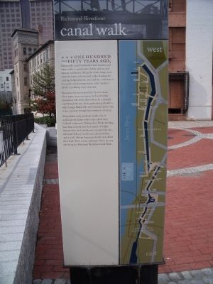
canal walk
One hundred and fifty years ago, Richmond’s waterfront bustled with business and trade, workers and travelers, hotels, saloons, and tobacco warehouses. Along the canals, barges were towed by teams of horses and mules. Batteaux for carrying freight plied the river and the canal around the rapids, and passenger boats, called “packets,” left for Lynchburg every other day.
Richmond has now restored its historic canals. Once again, boats can bypass the beautiful but treacherous falls of the James River for a leisurely trip through the city. And a pedestrian path offers a walk through Richmond’s new riverfront district that is also a journey through four centuries of history.
Along Richmond’s riverfront are sites of millennia-old Indian trade routes and of early Colonial settlements. Tredegar Iron Works buildings have been restored, and the remains of bridges burned when the Confederates evacuated the city still stand. Tobacco warehouses, electric trolleys, and an early African American church have all left their mark. Their stories, and many others, are now told along the Richmond Riverfront Canal Walk.
Erected by Richmond Riverfront Canal Walk.
Topics. This historical marker is listed in these topic lists: Exploration • Settlements & Settlers • Waterways & Vessels. A significant historical month for this entry is May 1924.
Location. 37° 32.031′ N, 77° 26.176′ W. Marker is in Richmond, Virginia. It is in the Central Office District. Marker can be reached from the intersection of South 12th Street and East Byrd Street. This marker is on the Richmond Riverfront canal Walk. Touch for map. Marker is in this post office area: Richmond VA 23219, United States of America. Touch for directions.
Other nearby markers. At least 8 other markers are within walking distance of this marker. Christopher Newport Monument (a few steps from this marker); Electric Trolley (a few steps from this marker); Tidewater Connection Locks (within shouting distance of this marker); James River & Kanawha Canal (within shouting distance of this marker); Ross' Mill Race (within shouting distance of this marker); Gallego Mill Flume (about 300 feet away, measured in a direct line); Hydroelectric Plant (about 300 feet away); The Center of Industry in 18th and 19th Century Richmond (about 400 feet away). Touch for a list and map of all markers in Richmond.
More about this marker. On the upper left is a sketch with the caption, “Chief Powhatan and his men. The area around the falls of the James was part of the Powhatan Chiefdom, a social and political alliance of Indian peoples that extended to the coast. Detail from the 1629 London Edition map of Virginia, reprinted by Franklin Press, 1819. Valentine Museum.”
On the center left is a sketch with the caption, “Fishing from a dugout canoe on the James River. From Robert Beverley’s History of Virginia, 1705. Library of Virginia.”
On the center left is a “Painting of William Byrd II, attributed to Sir Godfrey Kneller. Valentine Museum”
On the lower left is an illustration entitled, “Plan of Richmond, 1742, created by William Byrd II and the surveyor William Mayo. Library of Virginia.”
Above, the cross installed at Gamble’s Hill, c. 1930 Valentine Museum
Above, background, detail from the 1742 Byrd plan of Richmond Library of Virginia
Background, illustration of an Indian village similar to those in 17th-century Tidewater Virginia. Watercolor by John White, 1585. Library of Virginia
On the right side of the canal walk panel is a map of the Richmond Riverfront Canal Walk.
Also see . . .
1. Richmond Riverfront Canal Walk. Venture Richmond (Submitted on October 29, 2009.)
2. James River and Kanawha Canal Historic District. National Register of Historic Places (Submitted on October 29, 2009.)
Credits. This page was last revised on February 1, 2023. It was originally submitted on October 29, 2009, by Bernard Fisher of Richmond, Virginia. This page has been viewed 4,003 times since then and 88 times this year. Photos: 1, 2, 3, 4. submitted on October 29, 2009, by Bernard Fisher of Richmond, Virginia. 5. submitted on November 2, 2009, by Bernard Fisher of Richmond, Virginia. 6. submitted on October 29, 2009, by Bernard Fisher of Richmond, Virginia. 7. submitted on May 10, 2012, by Bernard Fisher of Richmond, Virginia.
