Lake Township in Caseville in Huron County, Michigan — The American Midwest (Great Lakes)
Coastal Dunes
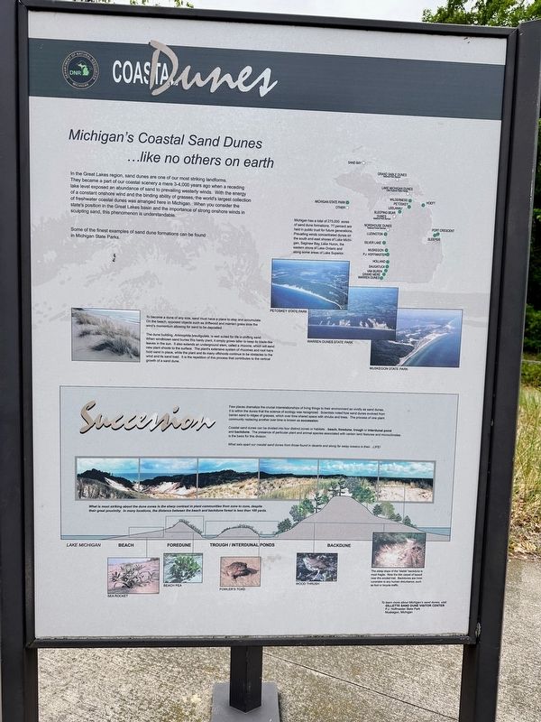
Michigan's Coastal Sand Dunes...like no others on earth
In the Great Lakes region, sand dunes are one of our most striking landforms. They became a part of our coastal scenery a mere 3-4,000 years ago when a receding lake level exposed an abundance of sand to prevailing westerly winds. With the energy of a constant onshore wind and the binding ability of grasses the world's largest collection of freshwater coastal dunes was arranged here in Michigan. When you consider the state's position in the Great Lakes basin and the importance of strong onshore winds in sculpting sand, this phenomenon is understandable.
Some of the finest examples of sand dune formations can be found in Michigan State Parks.
Succession
Few places dramatize the crucial interrelationships of living things to their environment as vividly as sand dunes. It is within the dunes that the science of ecology was recognized. Scientists noted how sand dunes evolved from barren sand to ridges of grasses which over time shared space with shrubs and trees. The process of one plant community replacing another over time is known as succession.
Coastal sand dunes can be divided into four distinct zones or habitats...beach, foredune, trough or interdunal pond and backdune. The presence of particular plant and animal species associated with certain land features and microclimates is the basis for this division.
What sets apart our coastal sand dunes from those found in deserts and along far bay oceans is their...LIFE!
Erected by Michigan Department of Natural Resources.
Topics. This historical marker is listed in these topic lists: Environment • Science & Medicine • Waterways & Vessels.
Location. 43° 58.864′ N, 83° 12.622′ W. Marker is in Caseville, Michigan, in Huron County. It is in Lake Township. Marker can be reached from Port Austin Road near Sleeper, on the right when traveling west. Touch for map. Marker is at or near this postal address: 5342 Port Austin Road, Caseville MI 48725, United States of America. Touch for directions.
Other nearby markers. At least 7 other markers are within 14 miles of this marker, measured as the crow flies. Methodist Episcopal Church (approx. 4 miles away); An Original 56# Rail (approx. 4.1 miles away); Pigeon Depot (approx. 10.9 miles away); Stagecoaches (approx. 12 miles away); Bay Port Fishing District (approx. 12.1 miles away); Great Fire of 1881 (approx. 13.9 miles away); Henry A. Hamp / Alfred R. Vogel (approx. 13.9 miles away).
Credits. This page was last revised on January 15, 2024. It was originally submitted on January 15, 2024, by J.T. Lambrou of New Boston, Michigan. This page has been viewed 49 times since then. Photos: 1, 2, 3. submitted on January 15, 2024, by J.T. Lambrou of New Boston, Michigan. • J. Makali Bruton was the editor who published this page.


