Charleston on Staten Island in Richmond County, New York — The American Northeast (Mid-Atlantic)
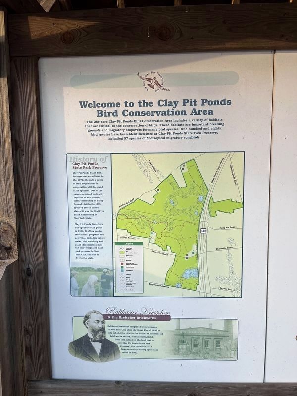
Welcome to the Clay Pit Ponds Bird Conservation Area
State Bird Conservation Area
Photographed by Devry Becker Jones (CC0), January 12, 2024
1. Welcome to the Clay Pit Ponds Bird Conservation Area Marker
The 260-acre Clay Pit Ponds Bird Conservation Area includes a variety of habitats that are critical to the conservation of birds. These habitats are important breeding grounds and migratory stopovers for many bird species. One hundred and eighty bird species have been identified here at Clay Pit Ponds State Park Preserve, including 57 species of Neotropical migratory songbirds.
History of Clay Pit Ponds State Park Preserve
Clay Pit Ponds State Park Preserve was established in the 1970s through a series of land acquisitions in cooperation with local and state agencies. One of the parcels acquired is directly adjacent to the historic black community of Sandy Ground. Settled in 1825 by freed Staten Island slaves, it was the first Free Black Community in New York State.
Clay Pit Ponds State Park was opened to the public in 1980. It offers passive recreational programs and activities, including nature walks, bird watching, and plant identification. It is the only designated state park preserve in New York City, and one of five in the state.
Balthasar Kreischer & the Kreischer Brickworks
Balthasar
this page online
The Clay Pit Ponds Bird Conservation Area (BCA) seeks to enhance populations of birds and provide habitat for breeding, shelter, and sustenance. To meet these needs, larger areas of contiguous habitat are better than an equal amount of habitat broken up into smaller patches.
In order for development and wildlife to co-exist, human activities must be made compatible with maintaining habitat. Conservation efforts such as the BCA program are an important step in this direction.
Biologists who study extinction rates on islands have concluded that species on islands decline at a faster rate if the island is small. Located on densely populated Staten Island, the Clay Pit Ponds BCA is an island of habitat surrounded not by water, but a sea of inhospitable habitat. By providing as large an island
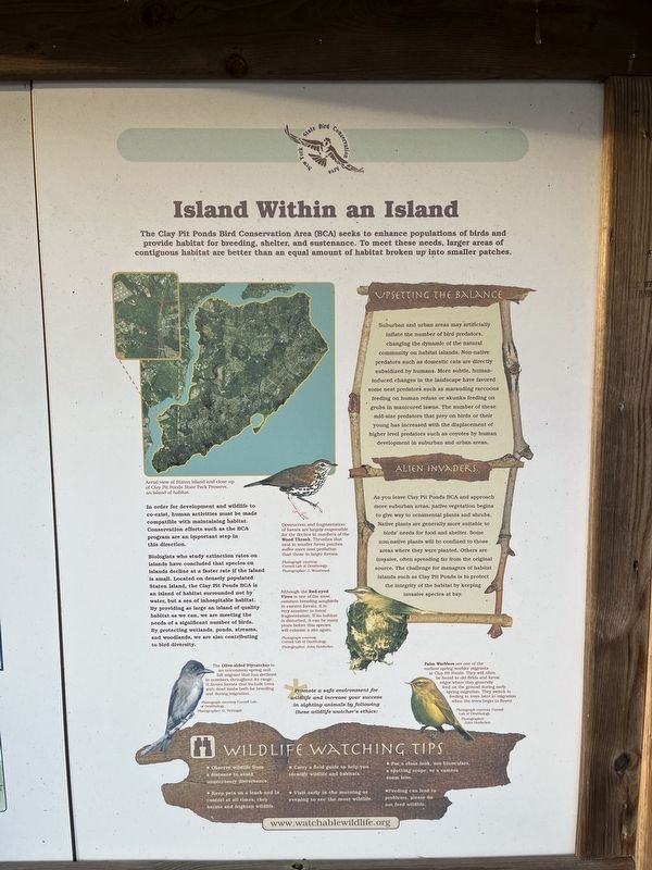
Upsetting the Balance
Suburban and urban areas may artificially inflate the number of bird predators, changing the dynamic of the natural community on habitat islands. Non-native predators such as domestic cats are directly subsidized by humans. More subtle, human induced changes in the landscape have favored some nest predators such as marauding raccoons feeding on human refuse or skunks feeding on grubs in manicured lawns. The number of these mid-size predators that prey on birds or their young has increased with the displacement of higher level predators such as coyotes by human development in suburban and urban areas.
Alien Invaders
As you leave Clay Pit Ponds BCA and approach more suburban areas, native vegetation begins to give way to ornamental plants and shrubs. Native plants are generally more suitable to birds' needs for food and shelter. Some non-native plants will be confined to those areas where they were planted. Others are invasive,
Photographed by Devry Becker Jones (CC0), January 12, 2024
3. New York State Bird Conservation Area panel
[Captions:]
Destruction and fragmentation of forests are largely responsible for the decline in numbers of the Wood Thrush. Thrushes that nest in smaller forest patches suffer more nest predation than those in larger forests.
Although the Red-eyed Vireo is one of the most common breeding songbirds in eastern forests, it is very sensitive to forest fragmentation. If its habitat is disturbed, it can be many years before this species will colonize a safe again.
The Olive-sided Flycatcher is an uncommon spring and fall migrant that has declined in numbers throughout its range. It favors forests that include trees with dead limbs both for breeding and during migration.
Palm Warblers are one of the earliest spring warbler migrants at Clay Pit Ponds. They will often be found in old fields and forest edges where they generally feed on the ground during early spring migration. They switch to feed in in trees later in migration when the trees begin to flower.
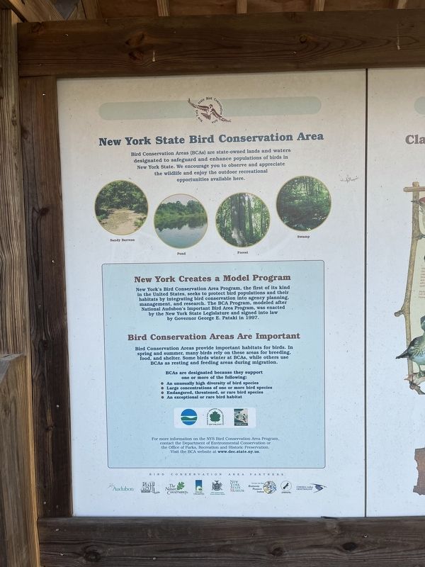
Bird Conservation Areas (BCAs) are state-owned lands and waters designated to safed and enhance populations of birds in New York State. We encourage you to observe and appreciate the wildlife and enjoy the outdoor recreational opportunities available here.
New York Creates a Model Program
New
Photographed by Devry Becker Jones (CC0), January 12, 2024
4. Clay Pit Ponds State Park Preserve: A Home for Birds panel
Bird Conservation Areas Are Important
Bird Conservation Areas provide important habitats for birds. In spring and summer, many birds rely on these areas for breeding, food, and shelter. Some birds winter at BCAs, while others use BCAs as resting and feeding areas during migration.
BCAs are designated because they support the following:
• An unusually high diversity of bird species
• Large concentrations of one or more bird species
• Endangered, threatened, or rare bird species
• An exceptional or rare bird habitat
For more information on the NYS Bird Conservation Area Program, contact the Department of Environmental Conservation or the Office of Parks, Recreation and Historic Preservation. Visit the BCA website at www.dec.state.ny.us.
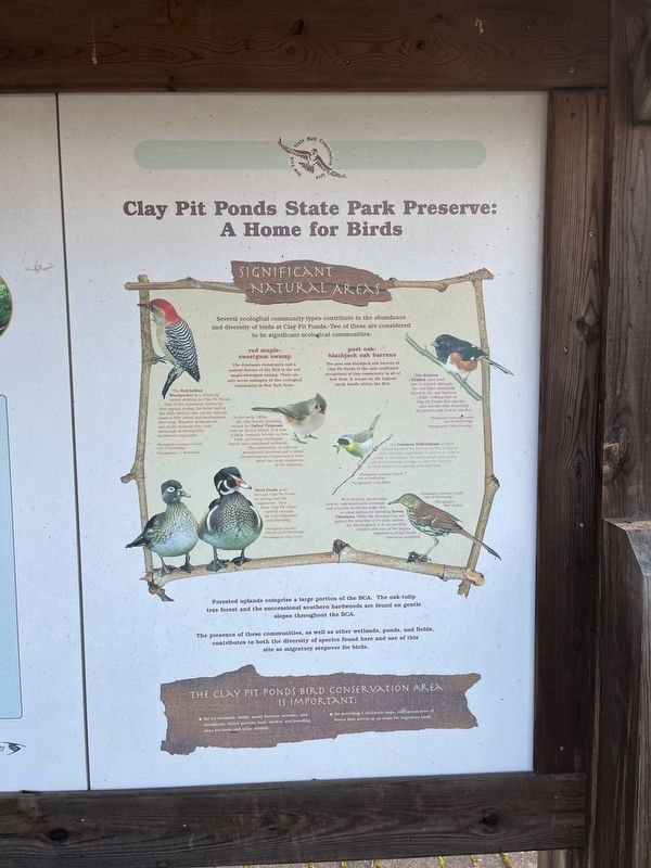
Significant Natural Areas
Several
![Welcome to the Clay Pit Ponds Bird Conservation Area Marker [Obverse] image. Click for full size.](Photos7/770/Photo770048.jpg?115202452100PM "Welcome to the Clay Pit Ponds Bird Conservation Area Marker [Obverse]. Click for full size.")
Photographed by Devry Becker Jones (CC0), January 12, 2024
5. Welcome to the Clay Pit Ponds Bird Conservation Area Marker [Obverse]
red maple-sweetgum swamp
The dominant community and a central feature of the BCA is the red maple-sweetgum swamp. There are only seven examples of this ecological community in New York State.
post oak-blackjack oak barrens
The post oak-blackjack oak barrens at Clay Pit Ponds is the only confirmed occurrence of this community in all of New York. It occurs on the highest sandy knolls within the BCA.
The Eastern Towhee uses both feet to scratch through the leaf litter commonly found in the oak barrens. While nesting here at Clay Pit Ponds this species also spends time searching for insects and fruit in shrubs.
The Red-bellied Woodpecker is a relatively recent addition to Clay Pit Ponds. One of the expansion routes for this species during the latter half of the 20th century was up the Atlantic coast to New Jersey and southeastern New York. Wooded wetlands are one of the habitats they took advantage of during this northward expansion.
In the early 1900s the only known breeding record for Tufted Titmouse was on Staten Island. It is now a fairly common breeder in New York, preferring deciduous forests with associated wetlands. The maturation of trees on abandoned farmland and a trend toward warmer temperatures have aided the range expansion of the titmouse.
The Common Yellowthroat is often found foraging for insects on the leaves of low, shrubby vegetation. It prefers to nest in moist or wet areas. The area where oak barren and shrub swamp overlap at Clay Pit Ponds is an ideal habitat for nesting yellowthroats.
Wood Ducks pass through Clay Pit Ponds on spring and fall migrations. They favor Clay Pit Ponds' wooded swamps for both migration and breeding.
Well-drained, sandy soils, patchy, oak-dominated overstory; and a variety of shrubs make this an ideal habitat for breeding Brown Thrashers. While the thrasher has not gained the notoriety of its close relative, the Mockingbird, it is an excellent vocalist with one of the largest repertoires of any North American songbird.
Forested
![Welcome to the Clay Pit Ponds Bird Conservation Area Marker [Reverse] image. Click for full size.](Photos7/770/Photo770054.jpg?115202454800PM "Welcome to the Clay Pit Ponds Bird Conservation Area Marker [Reverse]. Click for full size.")
Photographed by Devry Becker Jones (CC0), January 12, 2024
6. Welcome to the Clay Pit Ponds Bird Conservation Area Marker [Reverse]
The presence of these communities, as well as other wetlands, ponds, and fields, contributes to both the diversity of species found here and use of this site as migratory stopover for birds.
The Clay Pit Ponds Bird Conservation Area is important:
• for its wetlands, fields, and sandy barrens, streams, and woodlands, which provide food, shelter, and breeding sites for birds and other wildlife.
• for providing a relatively large, contiguous area of forest that serves as an oasis for migratory birds.
Erected by New York State Office of Parks, Recreation, and Historic Preservation.
Topics. This historical marker is listed in these topic lists: African Americans • Animals • Environment • Industry & Commerce • Parks & Recreational Areas • Settlements & Settlers. A significant historical year for this entry is 1825.
Location. 40° 32.255′ N, 74° 13.542′ W. Marker is on Staten Island, New York, in Richmond County. It is in Charleston. It can be reached from Sharrotts Road west of Veterans Road West, on the right when traveling west. Touch for map. Marker is at or near this postal address: 221 Sharrotts Road, Staten Island NY 10309, United States of America. Touch for directions.

Regionally, this marker is in New York City. It is also in the American Northeast, in the Mid-Atlantic, and on the Eastern Seaboard. Globally, it is in the North Atlantic Region, North America, the Western Hemisphere, the Western World, and the Anglosphere. Historically, it finds itself in what was once New Netherland and also one of the original Thirteen Colonies.
Other nearby markers. At least 8 other markers are within one mile of this marker, measured as the crow flies: September 11, 2001 Memorial (here, next to this marker); A Forest Reborn (approx. half a mile away); Fairview Park (approx. 0.6 miles away); Welcome to Kreischerville (approx. 0.6 miles away); Charleston War Memorial (approx. 0.6 miles away); The Gericke/Winant Farm (approx. 0.7 miles away); Pleasant Plains Memorial (approx. 1.1 miles away); a different marker also named Charleston War Memorial (approx. 1.1 miles away). Touch for a list and map of all markers in Staten Island.
Credits. This page was last revised on January 15, 2024. It was originally submitted on January 15, 2024, by Devry Becker Jones of Washington, District of Columbia. This page has been viewed 381 times since then and 75 times this year. Photos: 1, 2, 3, 4, 5, 6. submitted on January 15, 2024, by Devry Becker Jones of Washington, District of Columbia.
