Alapocas Run State Park near Wilmington in New Castle County, Delaware — The American Northeast (Mid-Atlantic)
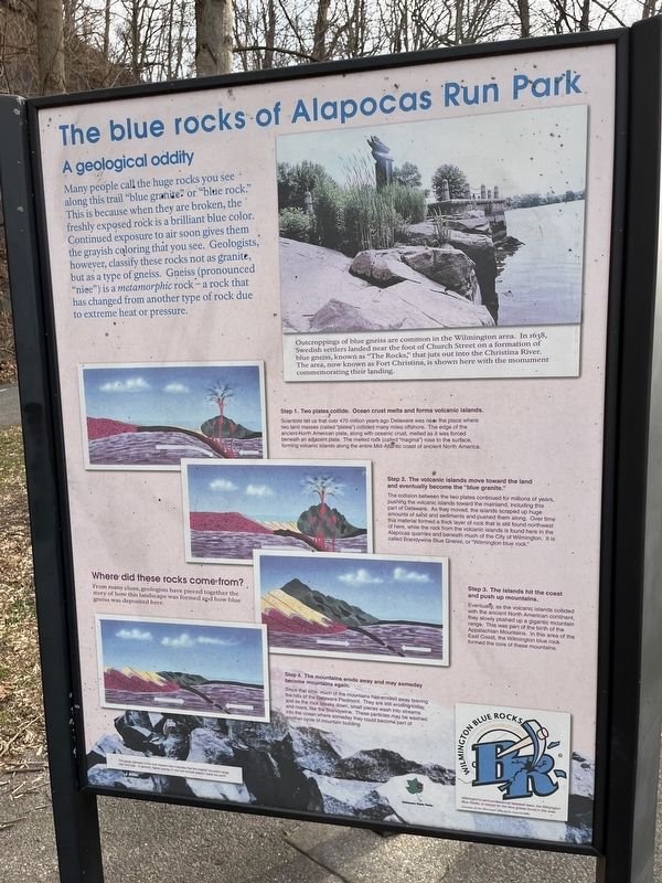
The blue rocks of Alapocas Run Park
A geological oddity
Many people call the huge rocks you see along this trail "blue granite" or "blue rock." This is because when they are broken, the fresh exposed rock is a brilliant blue color. Continued exposure to air soon gives them the grayish coloring that you see. Geologists, however, classify these rocks not as granite, but as a type of gneiss. Gneiss (pronounced "nice") is a metamorphic rock — a rock that has changed from another type of rock due to extreme heat or pressure.
Where did these rocks come from?
From many clues, geologists have pieced together the story of how this landscape was formed and how blue gneiss was deposited here.
Step 1. Two plates collide. Ocean crust melts and forms volcanic islands.
Scientists tell us that over 470 million years ago Delaware was near the place where two land masses (called "plates") collided many miles offshore. The edge of the ancient North American plate, along with the oceanic crust, melted as it was forced beneath an adjacent plate. The melted rock (called "magma") rose to the surface, forming volcanic islands along the entire Mid-Atlantic coast of ancient North America.
Step 2. The volcanic islands move toward the land and eventually become the "blue granite."
The collision between the two plates continued for millions of years, pushing the volcanic islands toward the mainland, including this part of Delaware. As they moved, the islands scraped up huge amounts of sand and sediments and pushed them along. Over time, this material formed a thick layer of rock that is still found northwest of here, while the rock from the volcanic islands is found here in the Alapocas quarries and beneath much of the City of Wilmington. It is called Brandywine Blue Gneiss, or "Wilmington blue rock."
Step 3. The islands hit the coast and push up mountains.
Eventually, as the volcanic islands collided with the ancient North American continent, they slowly pushed up a gigantic mountain range. This was part of the birth of the Appalachian Mountains. In this area of the East Coast, the Wilmington blue rock formed the core of these mountains.
Step 4. The mountains erode away and may someday become mountains again.
Since that time, much of the mountains has eroded away leaving the hills of the Delaware Piedmont. They are still eroding today, and as the rock breaks down, small pieces wash into streams and rivers, like the Brandywine. These particles may be washed into the ocean where someday they could become part of another cycle of mountain building.
[Captions:]
Outcroppings of blue gneiss are common in the Wilmington area. In 1638, Swedish settlers landed near the foot of Church Street on a formation of blue gneiss, known as "The Rocks," that juts out into the Christina River. The area, now known as Fort Christina, is shown here with the monument commemorating their landing.
The grade (density) of the rock located here indicates that the original mountain range was very high. In general, higher grades of rock are formed deeper inside the earth.
Washington Blue Rocks
Wilmington's semi-professional baseball team, the Wilmington Blue Rocks, is named for the blue gneiss found in this area.
Erected by Delaware State Parks.
Topics and series. This historical marker is listed in these topic lists: Colonial Era • Natural Features • Settlements & Settlers • Sports • Waterways & Vessels. In addition, it is included in the Delaware State Parks series list. A significant historical year for this entry is 1638.
Location. 39° 46.169′ N, 75° 33.598′ W. Marker is near Wilmington, Delaware, in New Castle County. It is in Alapocas Run State Park. Marker is on Northern Delaware Greenway Trail, on the right when traveling north. Touch for map. Marker is at or near this postal address: 304 Mill Rd, Wilmington DE 19803, United States of America. Touch for directions.
Other nearby markers. At least 8 other markers are within walking distance of this marker. Alapocas Run Park (here, next to this marker); Joseph Bancroft and His Legacy (about 700 feet away, measured in a direct line); A Family Company (about 700 feet away); Bancroft Mills (about 700 feet away); Ruth Ann Minner, Governor (approx. 0.3 miles away); Welcome to the Delaware Art Museum Labyrinth (approx. 0.3 miles away); Site of Gilpin Mills (approx. 0.4 miles away); Wilmington Friends School (approx. 0.4 miles away). Touch for a list and map of all markers in Wilmington.
Credits. This page was last revised on February 10, 2024. It was originally submitted on February 10, 2024, by Devry Becker Jones of Washington, District of Columbia. This page has been viewed 77 times since then. Photo 1. submitted on February 10, 2024, by Devry Becker Jones of Washington, District of Columbia.
Editor’s want-list for this marker. A wide shot of the marker in context. • Can you help?
