Spring Township near Elliottsburg in Perry County, Pennsylvania — The American Northeast (Mid-Atlantic)
Pre-Civil War Transportation Development
Perry County Bicentennial
— 1820 - 2020 —

Photographed By Devry Becker Jones (CC0), February 23, 2024
1. Pre-Civil War Transportation Development Marker
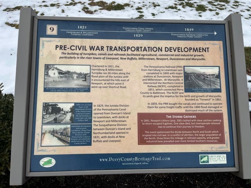
1821: Harrisburg & Millerstown Turnpike chartered.
1829: Pennsylvania Canal opened through Perry County.
1849: Pennsylvania Railroad completed through Perry County.
The building of turnpikes, canals and railroads facilitated agricultural, commercial and industrial growth, particularly in the river towns of Liverpool, New Buffalo, Millerstown, Newport, Duncannon and Marysville.
Chartered in 1821, the Harrisburg & Millerstown Turnpike ran 26 miles along the flood plain of the Juniata until it encountered the hills east of Newport, at which point it went up over Shortcut Road.
In 1829, the Juniata Division of the Pennsylvania Canal opened from Duncan's Island to Lewistown, with docks at Newport and Millerstown. The Susquehanna Division between Duncan's Island and Northumberland opened in 1831, with docks at New Buffalo and Liverpool
The Pennsylvania Railroad (PRR) from Harrisburg to Lewistown was completed in 1849 with major stations at Duncannon, Newport and Millerstown. At Marysville, it intersected the Northern Central Railway (NCRY), completed in 1851, which connected Perry County to Baltimore. The NCRY and its yards gave the impetus for the birth and growth of Marysville, founded as "Fenwick" in 1861.
In 1859, the PRR bought the canals and continued to operate them for some freight traffic until the 1889 flood damaged or destroyed much of the system.
[Sidbar:]
The Storm Gathers
In 1841, Newport citizens (pop. 200) clashed with slave catchers seeking to return escaped fugitives. One slave died, but townspeople released two to continue their journey to freedom.
This event epitomized the divide between the North and the South which erupted into civil war. In a conflict of attrition, the larger population of the North, three times the mileage in railroad capacity, and greater industrial base prevailed over more limited Southern resources.
[Captions:]
The turnpike is visible at the center of the photograph, with the Miller Pottery to the left, ca. 1850.
1880s view of canal boats on the Susquehanna Division of the Pennsylvania Canal at Liverpool. The tall building at center left is the Odd Fellows Hall.
Antebellum developments such as grain warehouses, lining Front Street and the Juniata Division of the Pennsylvania Canal at Newport, provided better market access for Perry County farmers.
Northern Central freight yard in Marysville, ca. 1860.
Erected 2020 by Historical Society of Perry County. (Marker Number 9.)

Photographed By Devry Becker Jones (CC0), February 23, 2024
2. Pre-Civil War Transportation Development Marker
Topics and series. This historical marker is listed in these topic lists: Abolition & Underground RR • Railroads & Streetcars • Roads & Vehicles • Waterways & Vessels. In addition, it is included in the Pennsylvania Canal, the Pennsylvania Railroad (PRR), and the Perry County Heritage Trail in Pennsylvania. series lists. A significant historical year for this entry is 1821.
Location. 40° 23.088′ N, 77° 17.85′ W. Marker is near Elliottsburg, Pennsylvania, in Perry County. It is in Spring Township. Marker can be reached from Shermans Valley Road (Pennsylvania Route 274) 0.4 miles east of Veterans Way (Pennsylvania Route 74), on the right when traveling west. Touch for map. Marker is at or near this postal address: 2471 Shermans Valley Rd, Elliottsburg PA 17024, United States of America. Touch for directions.
Other nearby markers. At least 8 other markers are within walking distance of this marker. Early Schools, Academies and Religious Institutions (here, next to this marker); Forces of Change 1945-2020 (here, next to this marker); Growth of Agriculture, Commerce and Industry Before the Civil War (here, next to this marker); Most Visible Changes 1945-2020 (here, next to this marker); The Perry County Home Front During World War II (here, next to this marker); Building on the Past as We March into the Future (a few steps from this marker); Perry County at Gettysburg: Summer of 1863 (a few steps from this marker); Post-Civil War Transformation (a few steps from this marker). Touch for a list and map of all markers in Elliottsburg.
Credits. This page was last revised on February 28, 2024. It was originally submitted on February 28, 2024, by Devry Becker Jones of Washington, District of Columbia. This page has been viewed 48 times since then. Photos: 1, 2. submitted on February 28, 2024, by Devry Becker Jones of Washington, District of Columbia.