Spring Township near Elliottsburg in Perry County, Pennsylvania — The American Northeast (Mid-Atlantic)
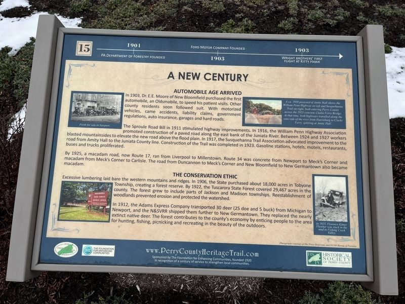
A New Century
Perry County Bicentennial
— 1820 - 2020 —
1901: PA Department of Forestry founded.
1903: Ford Motor Company founded.
1903: Wright brothers' first flight at Kitty Hawk.
Automobile Age Arrived
In 1903, Dr. E.E. Moore of New Bloomfield purchased the first automobile, an Oldsmobile, to speed his patient visits. Other county residents soon followed suit. With motorized vehicles, came accidents, liability claims, government regulations, auto insurance, garages and hard roads.
The Sproule Road Bill in 1911 stimulated highway improvements. In 1916, the William Penn Highway Association promoted construction of a paved road along the east bank of the Juniata River. Between 1924 and 1927 workers blasted mountainsides to elevate the new road above the flood plain. In 1917, the Susquehanna Trail Association advocated improvement to the road from Amity Hall to the Juniata County line. construction of the Trail was completed in 1927. Gasoline stations, hotels, motels, restaurants, buses and trucks proliferated.
By 1925, a macadam road, now Route 17, ran from Liverpool to Millerstown. Route 34 was concrete from Newport to Meck's Corner and macadam from Meck's Corner to Carlisle. The road from Duncannon to Meck's Corner and New Bloomfield to New Germantown also became macadam.
The Conservation Ethic
Excessive lumbering laid bare the western mountains and ridges. In 1906, the State purchased about 18,000 acres in Tobyone Township, creating a forest reserve. By 1922, the Tuscarora State Forest covered 29,467 acres in the county. The forest grew to include parts of Jackson and Madison townships. Reestablishment of woodlands prevented erosion and protected the watershed.
In 1912, the Adams Express Company transported 30 deer (25 doe and 5 buck) from Michigan to Newport, and the N&SVRR shipped them further to New Germantown. They replaced the nearly extinct native deer. The forest contributes to the county's economy by enticing people to the area for hunting, fishing, picnicking and recreating in the beauty of the outdoors.
[Captions:]
Fords for sale in Newport.
A ca. 1930 postcard of Amity Hall shows the William Penn Highway on left and Susquehanna Trail on right, both entering Perry County across the 1925 concrete Clarks Ferry Bridge. At that time, both highways travelled along the east side of the river from Harrisburg to Clarks Ferry, splitting at Amity Hall.
In 1925, Florence Kitner Fleisher was stuck in the mud in Fishing Creek Valley.
Erected 2020 by The Foundation for Enhancing Communities; Historical Society of Perry County. (Marker
Topics and series. This historical marker is listed in these topic lists: Environment • Horticulture & Forestry • Roads & Vehicles • Science & Medicine. In addition, it is included in the Perry County Heritage Trail in Pennsylvania. series list. A significant historical year for this entry is 1901.
Location. 40° 23.079′ N, 77° 17.859′ W. Marker is near Elliottsburg, Pennsylvania, in Perry County. It is in Spring Township. Marker is on Shermans Valley Road (Pennsylvania Route 274) 0.4 miles east of Veterans Way (Pennsylvania Route 74), on the right when traveling west. Touch for map. Marker is at or near this postal address: 2471 Shermans Valley Rd, Elliottsburg PA 17024, United States of America. Touch for directions.
Other nearby markers. At least 8 other markers are within walking distance of this marker. Contact Between Widely Different Cultures (here, next to this marker); The First Inhabitants of Perry County (here, next to this marker); Indian Attacks in Shermans Valley (here, next to this marker); Perry County Covered Bridges (here, next to this marker); WW I and Its Aftermath (here, next to this marker); Transportation and Natural Resources (here, next to this marker); Life in the Great Depression (here, next to this marker); Perry Countians in the Revolutionary War (here, next to this marker). Touch for a list and map of all markers in Elliottsburg.
Credits. This page was last revised on February 29, 2024. It was originally submitted on February 29, 2024, by Devry Becker Jones of Washington, District of Columbia. This page has been viewed 43 times since then. Photos: 1, 2. submitted on February 29, 2024, by Devry Becker Jones of Washington, District of Columbia.

