Newville in Cumberland County, Pennsylvania — The American Northeast (Mid-Atlantic)
Big Spring Creek - Agriculture, Industry and Recreation
Cumberland Valley Rail Trail
— Cumberland Valley Rails-to-Trails —

Photographed By Devry Becker Jones (CC0), February 24, 2024
1. Big Spring Creek - Agriculture, Industry and Recreation Marker
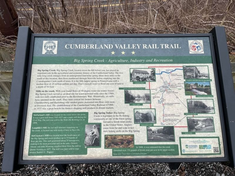
Big Spring Creek: Big Spring Creek, located down the hill before you, has played an important role in the agricultural and economic history of the Cumberland Valley. The five-mile-long creek emerges from an underground limestone spring about three miles to the south of this location, then flows northward through Newville before emptying into the Conodoguinet Creek north of town. It is the fifth largest spring in Pennsylvania with a median flow of 18 million gallons per day. That's enough water to flood one acre of land to a depth of 54 feet!
Mills on the creek: With year-round flows of 50-degree water (no winter freeze) Big Spring Creek served as an ideal site for water-powered mills since the 1760s, with two mills established prior to the Revolutionary War. Historically, six mills have operated on the creek. They were critical for farmers between Chambersburg and Harrisburg who needed grains processed into flower, corn meal, or livestock feed. The establishment of the Cumberland Valley Railroad (CVRR) in 1837 was a great benefit for farmers shipping mills products to distant markets.
Big Spring Today: Big Spring Creek is legendary in the fly-fishing community as one of the finest spring-fed native brook trout creeks in the United States. Anglers come from far and wide to test their fishing skills on the Big Spring.
McFarland's Mill was located on the creek below this point. It was a grist mill from 1765-1827 and a paper mill during the Civil War. The mill was sold to the Newville Knitting Co. in 1898.
Laughlin's Mill, the last mill structure remaining on the creek, is located one mile north of here in Newville.
McCracken's Mill was located near the headwaters of the Big Spring and could produce up to 75 barrels of flour per day. This mill generated about 35 horsepower, making it the most powerful mill in the area. Owners Abram and John Manning supplied flour from the mill to Queen Victoria in 1877. The mill was later sold to state senator Samuel C. Wagner.
[Caption:]
In 2008, it was estimated that the creek contained over 350 pounds of brook trout per acre in its upper section.
Erected by Cumberland Valley Trail Connections; Pennsylvania Department of Conservation and Natural Resources; Appalachian Trail Conservancy; South Mountain Partnership.
Topics. This historical marker is listed in these topic lists: Agriculture • Industry & Commerce • Parks & Recreational Areas • Waterways & Vessels. A significant historical year for this entry is 1837.
Location. 40° 9.96′ N, 77° 24.143′

Photographed By Devry Becker Jones (CC0), February 24, 2024
2. Big Spring Creek - Agriculture, Industry and Recreation Marker
Other nearby markers. At least 8 other markers are within walking distance of this marker. State Police School (about 400 feet away, measured in a direct line); The Big Spring Hotel (about 400 feet away); First United Presbyterian Church and Manse (approx. 0.2 miles away); The Byers-Eckels House (approx. 0.2 miles away); Newville Trolley (approx. ¼ mile away); Alexander Spring Creek Rail Bridge (approx. ¼ mile away); The Big Spring Adamantine Guards (approx. ¼ mile away); Newville (approx. 0.4 miles away). Touch for a list and map of all markers in Newville.
Credits. This page was last revised on March 28, 2024. It was originally submitted on March 1, 2024, by Devry Becker Jones of Washington, District of Columbia. This page has been viewed 44 times since then. Photos: 1, 2. submitted on March 1, 2024, by Devry Becker Jones of Washington, District of Columbia.