
Kenora in Kenora District, Ontario — Central Canada (North America)
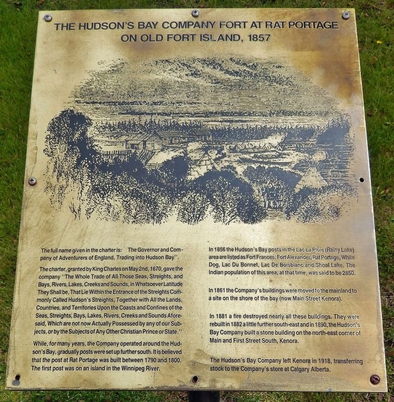
The Hudson's Bay Company Fort at Rat Portage on Old Fort Island, 1857
Photographed by Cosmos Mariner, June 13, 2022
1. The Hudson's Bay Company Fort at Rat Portage on Old Fort Island Marker
The full name given in the charter is: “The Governor and Company of Adventurers of England, Trading into Hudson Bay”.
The charter, granted by King Charles on May 2nd, 1670, gave the company “The Whole Trade of All Those Seas, Streights, and Bays, Rivers, Lakes, Creeks and Sounds, in Whatsoever Latitude They Shall be, That Lie Within the Entrance of the Streights Commonly Called Hudson's Streights, Together with All the Lands, Countries, and Territories Upon the Coasts and Confines of the Seas, Streights, Bays, Lakes, Rivers, Creeks and Sounds Aforesaid, Which are not now Actually Possessed by any of our Subjects, or by the Subjects of Any Other Christian Prince or State.”
While, for many years, the Company operated around the Hudson's Bay, gradually posts were set up further south. It is believed that the post at Rat Portage was built between 1790 and 1800. The first post was on an island in the Winnipeg River.
In 1856 the Hudson's Bay posts in the Lac La Pluie (Rainy Lake) area are listed as Fort Frances, Fort Alexander, Rat Portage, White Dog, Lac Du Bonnet, Lac De Boisblanc and Shoal Lake. The Indian population of this
this page online
In 1861 the Company's buildings were moved to the mainland to a site on the shore of the bay (now Main Street Kenora).
In 1881 a fire destroyed nearly all these buildings. They were rebuilt in 1882 a little further south-east and in 1890, the Hudson's Bay Company built a stone building on the north-east corner of Main and First Street South, Kenora.
The Hudson's Bay Company left Kenora in 1918, transferring stock to the Company's store at Calgary Alberta.
Topics. This historical marker is listed in these topic lists: Colonial Era • Exploration • Industry & Commerce • Waterways & Vessels. A significant historical date for this entry is May 2, 1670.
Location. 49° 46.139′ N, 94° 29.46′ W. Marker is in Kenora, Ontario, in Kenora District. It can be reached from Bernier Drive just south of Main Street South (Trans-Canada Highway) (Provincial Highway 17), on the right when traveling south. The marker is located along the Kenora Bay waterfront walkway, on the north side of the pavilion. Touch for map. Marker is in this post office area: Kenora ON P9N 1S4, Canada. Touch for directions.

Regionally,

Photographed by Cosmos Mariner, June 13, 2022
2. The Hudson's Bay Company Fort at Rat Portage on Old Fort Island Marker
Looking east from the waterfront walkway; Bernier Drive is in the background.
Other nearby markers. At least 8 other markers are within walking distance of this marker: Governor General's Arrival (here, next to this marker); Early Exploration (here, next to this marker); Town of Kenora Waterfront History (here, next to this marker); A 1920 View of Today's McLeod Park (a few steps from this marker); The Boundary Dispute (a few steps from this marker); Transportation (a few steps from this marker); Rat Portage Rowing Club (about 90 meters away, measured in a direct line); Flame on the Water — 1995 (about 90 meters away). Touch for a list and map of all markers in Kenora.
Also see . . . The Hudson's Bay Company in Rat Portage. Excerpt:
(by Marcus Jeffrey) In the years before Canada was a nation – long before the automobile, airplane, or steam locomotive – the Lake of the Woods was the province of adventurers and fur-traders. Much of the written history detailing early life on the lake comes from the Hudson’s Bay Company, who maintained a presence at Rat Portage for nearly two hundred years. As generations of explorers sought new routes to the west, the meeting points of the Lake of the Woods and Winnipeg River grew from mere geographical features to trading posts, villages, and towns. Canoes gave way to steamboats, iron rails replaced wagon trails, and a way of life that once defined Rupert’s Land vanished.(Submitted on April 20, 2024, by Cosmos Mariner of Cape Canaveral, Florida.)
Credits. This page was last revised on April 20, 2024. It was originally submitted on April 16, 2024, by Cosmos Mariner of Cape Canaveral, Florida. This page has been viewed 655 times since then and 84 times this year. Photos: 1, 2. submitted on April 20, 2024, by Cosmos Mariner of Cape Canaveral, Florida.
