Homestead in Miami-Dade County, Florida — The American South (South Atlantic)
HMS Fowey Cannon
| — | Biscayne National Park | — |

Photographed by Darren Jefferson Clay, March 17, 2024
1. HMS Fowey Cannon Marker
Durante 235 años, este cañón de hierro estuvo en el fondo del mar, a sola 13 millas (21 km) de donde usted está parado. Los arqueólogos sustrajeron este cañón del sitio del naufragio del HMS Fowey en 1983. El HMS Fowey fue un barco de guerra británico, hundido en el 1748 después de golpear un arrecife en las aguas llanas de lo que hoy es Biscayne National Park.
Identifying a Cannon
Before she sank in 1748, HMS Fowey carried over 200 sailors and 44 guns on her small decks. These cannon varied in size and fired shot that weighed 6, 9, or 18 pounds. Cannon are often classified based on the weight of their shot. This cannon is referred to as a "9-pounder" because it could fire 9-pound shot. The gun actually weighs nearly 3000 pounds.
Antes de que el barco se hundiera en 1748, HMS Fowey llevó a cabo más de 200 marineros
this page online
Messages and Marks
Cannon are often stamped or engraved with symbols that tell us about their origins. On this cannon from HMS Fowey, a "Tudor Rose" crest is visible. The crest suggests that the cannon was the property of the British Crown. Further down the gun barrel, the British "broad arrow" is also visible. This symbol indicates British military ownership. The presence of the broad arrow on many of HMS Fowey's artifacts initially helped archeologists conclude that the shipwreck was a British warship. The "19" engraved near the Tudor Rose crest is a foundry mark and indicates the gun's production number in a sequence of cannon.
A menudo, los cañones están grabados con símbolos que indican sus origenes. Por ejemplo, este cañón de HMS Fowey tiene una cresta de "Tudor Rose."

Photographed by Darren Jefferson Clay, March 17, 2024
2. HMS Fowey Cannon Marker
Conservation
After archeologists excavate a shipwreck site, any artifacts they collect need to undergo special treatment. These treatments remove corrosion products and marine growth, revealing an artifact's important details. Conservation also removes salts that can contribute to future deterioration. No conservation treatment is perfect, however, and conserved items require special handling. This cannon is maintained in a low humidity environment to ensure its preservation into the future.
Después que los arqueólogos excavan un sitio de naufragio, cualquier artefacto adquirido requiere pasar por un tratamiento especial. Estos tratamientos quitan los productos de corrosión
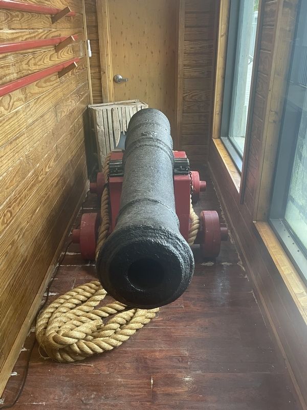
Photographed by Darren Jefferson Clay, March 17, 2024
3. HMS Fowey Cannon
Erected by National Park Service, U.S. Department of the Interior.
Topics. This historical marker is listed in these topic lists: Colonial Era • Waterways & Vessels. A significant historical year for this entry is 1748.
Location. 25° 27.872′ N, 80° 20.084′ W. Marker is in Homestead, Florida, in Miami-Dade County. It can be reached from Southwest 328th Street 2.6 miles east of Southwest 117th Avenue when traveling east. Located at the rear of the Dante Fascell Visitor Center. Touch for map. Marker is at or near this postal address: 9700 SW 328th St, Homestead FL 33033, United States of America. Touch for directions.

Regionally, this marker is in South Florida, on the Gold Coast, and in Greater Miami. It is also in the American South and on the Eastern Seaboard. Globally, it is in the North Atlantic Region, North America, a Gulf of Mexico state, the Western Hemisphere, the Western World, and the Anglosphere. Historically, it finds itself in what was once New Spain, the territory of the Mississippian Culture, one of the Confederate States of America, and the Antebellum South.
Other nearby markers. At least 8 other markers are within walking distance of this marker: His Majesty's Ship Fowey (here, next to this marker); Maritime Heritage Trail (a few steps from this marker); Dante B. Fascell (a few steps from this marker); Hurricane Andrew (a few steps from this marker); The Jones Family of Biscayne (within shouting distance of this marker); Two Parks, Divided (within shouting distance of this marker); Ring the Biscayne Channel Sea Bell! (within shouting distance of this marker); The Edge of "Progress" / Al Margen del "Progreso" (within shouting distance of this marker). Touch for a list and map of all markers in Homestead.
Also see . . . Biscayne National Park. National Park Service (Submitted on May 1, 2024.)
Credits. This page was last revised on May 1, 2024. It was originally submitted on April 29, 2024, by Darren Jefferson Clay of Duluth, Georgia. This page has been viewed 292 times since then and 56 times this year. Photos: 1, 2, 3. submitted on April 30, 2024, by Darren Jefferson Clay of Duluth, Georgia. • Bernard Fisher was the editor who published this page.
