Manassas, Virginia — The American South (Mid-Atlantic)
Wartime Manassas
Jackson’s Daring Raid
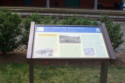
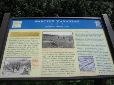
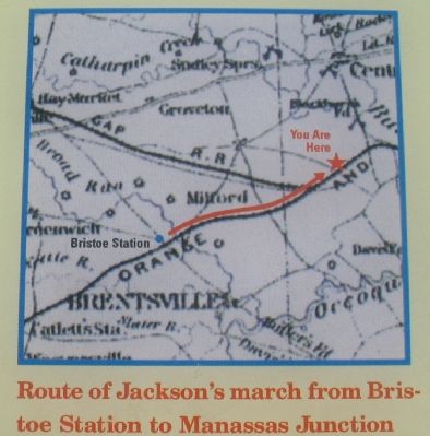
You are standing at the site of a massive Federal supply depot. On August 24, 1862, Confederate Gen. Robert E. Lee sent Gen. Thomas J. “Stonewall” Jackson and his forces on a sweeping march north and east around Union Gen. John Pope’s right flank to cut the Federal supply line and force Pope out of his defenses. Lee followed with Gen. James Longstreet’s command. A day and a half later, Jackson arrived at Briscoe Station, a few miles west of here on the Orange and Alexandria Railroad, where he tore up the track, destroyed the bridge over Broad Run, and derailed two Federal supply trains. He then launched a night attack on Manassas Junction, capturing 300 Union prisoners and 200 railroad cars loaded with delicacies. His hungry men swarmed through this area, ate the fill, loaded their knapsacks, and burned all that remained. Learning that Pope was marching towards him, Jackson led his men to the Old Manassas battleground and took up a strong position to await Lee and Longstreet.
“Just imagine about 6000 men hungry and almost naked, let loose on some million dollars worth of biscuit, cheese, ham, bacon, messpork, coffee, sugar, tea, fruit, brandy, wine, whiskey, oysters; coats, pants, shirts, caps, boots, shoes, socks, blankets, tents, etc. etc. ... I saw the whole army become what appeared to me an ungovernable mob, drunk, some few with liquor but the others with excitement.” —Chaplain James S. Sheeran, 14th Louisiana Infantry
“Twas a curious sight to see our ragged & famished men helping themselves to every imaginable article of luxury or necessity whether of clothing, food, or what not. ... We had been living on roasted corn since crossing Rappahannock, & we had not brought no new wagons so we could carry little away of the riches before us. But the men could eat for one meal at least, so they were marched up and as much of everything eatable served out as they could carry. To see a starving man eating lobster salad and drinking ... rhine wine, barefooted & in tatters was curious; the whole thing indescribable.” —Lt. John H. Chamberlayne, Purcell Artillery
Erected by Virginia Civil War Trails.
Topics and series. This historical marker is listed in these topic lists: Railroads & Streetcars • War, US Civil. In addition, it is included in the Virginia Civil War Trails, and the Virginia, Wartime Manassas Walking Tour series lists. A significant historical date for this entry is August 24, 1862.
Location. Marker has been reported missing. It was located near 38° 45.02′ N, 77° 28.374′ W. Marker was in Manassas, Virginia. Marker was on the sidewalk north of the railroad tracks east of West Street, on the right when traveling east. Touch for map. Marker was in this post office area: Manassas VA 20110, United States of America. Touch for directions.
Other nearby markers. At least 8 other markers are within walking distance of this location. Jackson's Raid (here, next to this marker); A Railroad Town (a few steps from this marker); a different marker also named Wartime Manassas (within shouting distance of this marker); Site of Manassas Junction (within shouting distance of this marker); a different marker also named Wartime Manassas (within shouting distance of this marker); The Town Is Born (within shouting distance of this marker); Route of the "Old 97" (within shouting distance of this marker); Loy E. Harris (within shouting distance of this marker). Touch for a list and map of all markers in Manassas.
More about this marker. One in the series of Wartime Manassas Virginia Civil War Trails Marker.
Related markers. Click here for a list of markers that are related to this marker. To better understand the relationship, study each marker in the order shown.
Also see . . .
1. Lee's Operations Along the Rapidan and Rappahannock. Photos on this page includes "Jackson's troops pillaging Federal supplies at Manassas Junction" and "Manassas Junction as it looked after Jackson's raid." (Submitted on August 25, 2006.)
2. Short brography of Stonewall Jackson. This page includes a portrait of Jackson. (Submitted on August 25, 2006.)
Credits. This page was last revised on February 19, 2024. It was originally submitted on August 25, 2006, by Tom Fuchs of Greenbelt, Maryland. This page has been viewed 2,401 times since then and 29 times this year. Last updated on February 19, 2024, by Mike McKeown of Baltimore, Maryland. Photos: 1. submitted on August 25, 2006, by Tom Fuchs of Greenbelt, Maryland. 2, 3. submitted on September 3, 2007, by Craig Swain of Leesburg, Virginia. • Bernard Fisher was the editor who published this page.


