Webster Station in Dayton in Montgomery County, Ohio — The American Midwest (Great Lakes)
Location of the Canal in Dayton
Patterson Boulevard Canal Parkway
Photographed by Craig Doda, May 4, 2024
1. Location of the Canal in Dayton Marker
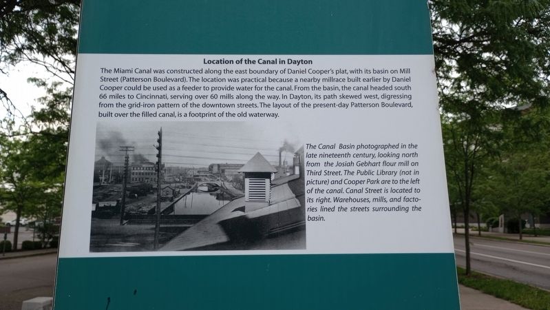
The Miami Canal was constructed along the east boundary of Daniel Cooper's plat, with its basin on Mill Street (Patterson Boulevard). The location was practical because a nearby millrace built earlier by Daniel Cooper could be used as a feeder to provide water for the canal. From the basin, the canal headed south 66 miles to Cincinnati, serving over 60 mills along the way. In Dayton, its path skewed west, digressing from the grid-iron pattern of the downtown streets. The layout of the present-day Patterson Boulevard, built over the filled canal, is a footprint of the old waterway.
[Caption:]
The Canal Basin photographed in the late nineteenth century, looking north from the Josiah Gebhart flour mill on Third Street. The Public Library (not in picture) and Cooper Park are to the left of the canal. Canal Street is located to its right. Warehouses, mills, and factories lined the streets surrounding the basin.
Erected 2017.
Topics and series. This historical marker is listed in these topic lists: Industry & Commerce • Roads & Vehicles • Waterways & Vessels. In addition, it is included in the The Miami & Erie Canal
this page online
Location. 39° 45.705′ N, 84° 11.211′ W. Marker is in Dayton, Ohio, in Montgomery County. It is in Webster Station. It is at the intersection of North Patterson Boulevard and East 2nd Street, on the right when traveling north on North Patterson Boulevard. Touch for map. Marker is at or near this postal address: 251 E 2nd St, Dayton OH 45402, United States of America. Touch for directions.

Regionally, this marker is in Ohio’s Miami Valley. It is also in the American Midwest and in the Corn Belt. Globally, it is in North America, the Western Hemisphere, the Western World, and the Anglosphere. Historically, it finds itself in what was once the Haudenosaunee (Iroquois) Confederacy, the territory of the Mississippian Culture, and the Northwest Territory.
Other nearby markers. At least 8 other markers are within walking distance of this marker: The Need for Waterways (here, next to this marker); Elephants in the Canal (here, next to this marker); Commerce at the Canal Basin (here, next to this marker); Trade at the Canal Basin (here, next to this marker); The Miami Erie Canal in Dayton
Photographed by Craig Doda, May 4, 2024
2. Location of the Canal in Dayton Marker
Credits. This page was last revised on May 16, 2024. It was originally submitted on May 16, 2024, by Craig Doda of Napoleon, Ohio. This page has been viewed 142 times since then and 19 times this year. Photos: 1, 2. submitted on May 16, 2024, by Craig Doda of Napoleon, Ohio. • Devry Becker Jones was the editor who published this page.
