Winchester, Virginia — The American South (Mid-Atlantic)
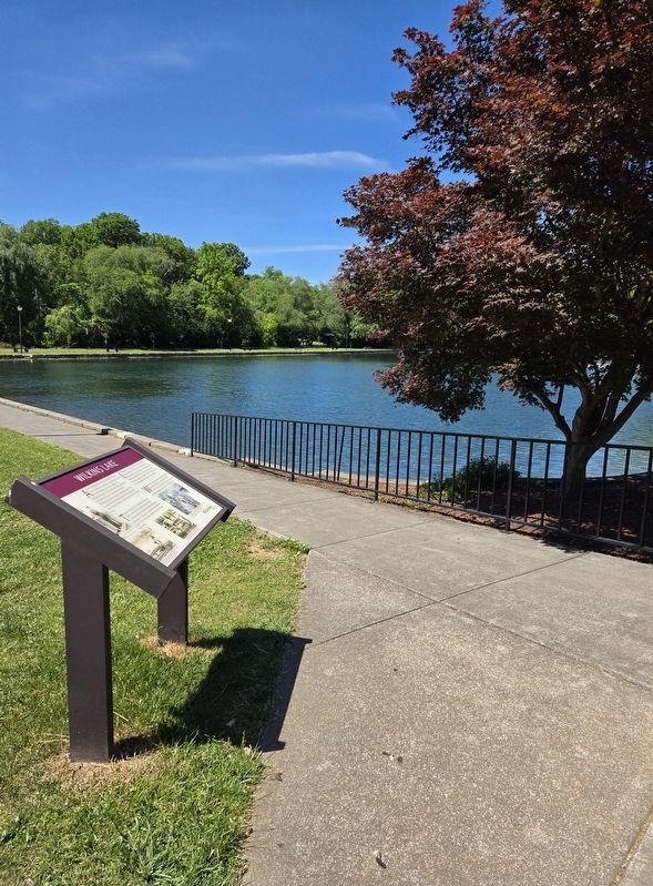
Wilkins Lake

Photographed by Bradley Owen, May 31, 2024
1. Wilkins Lake Marker
A prominent Winchester Citizen and Philanthropist, James R. Wilkins Sr., had an idea dating back to the 1950's for a lake to serve the residents of Winchester, Virginia. He also felt that you must reinvest your profits into your community. This love of community, outdoor recreation and fishing led to the development of a 3.5-acre parcel of brush and swamp land to become Wilkins Lake in what is now Jim Barnett Park.
Through a donation from the Wilkins family, the State Commission of Outdoor Recreation and private contributions, groundbreaking took place on September 16, 1982 with a completion and dedication on April 7, 1984. This newly built lake was and is fed by Rouss Spring.
In 1999, plans for a pier, walkway and streetlights to provide nighttime illumination, and a 5-foot tall retaining wall to prevent erosion were all part of the next phase of Wilkins Lake. This was made possible thanks to a generous donation from the Wilkins family. The rededication took place on June 9, 2000.
Wilkins Lake remains a place for fishermen (both new and seasoned) to cast, a place for all to come and relax, to take a leisurely
this page online
(Captions):
James Wilkins Jr. (left) and James Wilkins Sr. casting a line at Wilkins Lake.
Courtesy of Winchester Star - Photo by Scott Mason
Employees of H&W Construction of Winchester working on the new bridge for the perimeter sidewalk at Wilkins Lake, April 7, 2000.
Courtesy of Northern Virginia Daily - Photo by Alan Lehman
Wilkins Lake getting stocked for the first time. April 3, 1984.
Courtesy of Northern Virginia Daily - Photo by Rich Cooley
The keystone, gray retaining wall, under construction, will halt lake erosion. A sidewalk was added to the areas around the lake, November 20, 1999.
Courtesy of Winchester Star - Photo by Rick Foster
Topics. This historical marker is listed in this topic list: Parks & Recreational Areas. A significant historical date for this entry is April 7, 1984.
Location. 39° 10.08′ N, 78° 9.581′ W. Marker is in Winchester, Virginia. It can be reached from University Drive 0.2 miles east of Millwood Avenue (U.S. 50), on the left when traveling east. Marker is located on the southwest side of Wilkins Lake on the campus of Shenandoah
Photographed by Bradley Owen, May 31, 2024
2. Wilkins Lake Marker

Regionally, this marker is in Virginia’s Shenandoah Valley. It is also in the American South, specifically in the Upper South, and in the Mid-Atlantic. Globally, it is in North America, the Western Hemisphere, the Western World, and the Anglosphere. Historically, it finds itself in what was once the territory of the Mississippian Culture, one of the original Thirteen Colonies, one of the Confederate States of America, and the Antebellum South.
Other nearby markers. At least 8 other markers are within walking distance of this marker: A different marker also named Abram's Delight (about 400 feet away); The Hollingsworth Family Settlement (about 500 feet away); The First Battle of Winchester (about 600 feet away); a different marker also named Abram's Delight (about 600 feet away); a different marker also named Abram’s Delight (about 600 feet away); Dr. James A. Davis's Legacy (about 600 feet away); Native Plants Garden (approx. 0.2 miles away); The Peacemakers (approx. 0.2 miles away).

Photographed by Bradley Owen, May 31, 2024
3. Wilkins Lake Plaque - Near the Marker
dedicated to honor
James Richard Wilkins
for his civic activities and determination
to build a better community
1983
Another marker is no longer nearby. Abram’s Delight (was about 400 feet away, measured in a direct line but has been reported to have been replaced with another marker now near it).

Photographed by Bradley Owen, May 31, 2024
4. Wilkins Lake
Credits. This page was last revised on June 2, 2024. It was originally submitted on June 2, 2024, by Bradley Owen of Morgantown, West Virginia. This page has been viewed 667 times since then and 96 times this year. Photos: 1, 2, 3, 4. submitted on June 2, 2024, by Bradley Owen of Morgantown, West Virginia.
