Fox Chapel in Allegheny County, Pennsylvania — The American Northeast (Mid-Atlantic)
O'Hara Township Community Park - People of the Longhouse
Photographed by Kelly Phillips, June 8, 2024
1. O'Hara Township Community Park - People of the Longhouse Marker
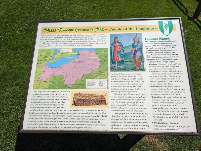
outline. The Longhouse is the signature structure of the Haudenosaunee in the Northeastern United States as well as Eastern Canada. A typical longhouse was traditionally home to multifamily units (up to 20 or more families) and it contained multiple hearths. Haudenosaunee society had a gendered worldview. It was a matriarchy tracing descent of blood from a common mother. The longhouse, cultivated lands, and social life were under the control of the women. This was called “the clearing.” Men as warriors, chiefs, hunters, and trappers conducted their affairs away from the clearing in “the forests.” Chiefs were warriors temporarily or permanently chosen
this page online
Traditional Haudenosaunee dress is shown in the above illustration. The male figure’s leggings could be made from deerskin or wool. The female figure’s dress displays the intricate beadwork of Seneca clothing. The male’s headdress showing a single feather is a Seneca cap called a gustoweh. Hanging from the male’s neck is a cresent-shaped metal gorget, which was worn by both Indians and English military. The English gifted gorgets as tokens of goodwill. Prior to European arrival, Indians wore stone gorgets as ornaments on the head or chest area.
The purple and white wampum belt displaying the Six Nations symbol was an important form of communication and was used for ceremonial purposes, diplomatic relations, and the recording of treaties or other historical events.
Familiar Names
The Delaware Nation (Lenni Lenape) came into Western Pennsylvania around 1720 after being driven from the east by colonial expansion.
Photographed by Kelly Phillips, June 8, 2024
2. O'Hara Township Community Park - People of the Longhouse Marker
• Aliquippa—(Lenape) alukwepi 'hat'; after the Seneca Queen Aliquippa, known for wearing a large hat.
• Allegheny—(Lenape) welhik hane or oolik hanna, which means “best flowing river of the hills.” The Senecas refer to the Allegheny as the “Ohhee-yo” (good river) and consider it as part of the Ohio River.
• Kiskiminetas—(Lenape) kishku manitu “make daylight,” a command to warriors to break camp and go on maneuvers while it is still night.
• Kittanning—(Lenape) kithanink “on the main river”: kit “great, large, big” + hane “swift river from the mountains” + -ink locative suffix.
• Monongahela—(Lenape) M naonkih la “the high riverbanks are washed down; the banks cave in or erode,” the plural of m naonkih le “the dirt caves off.”
• Youghiogheny—(Lenape)yuxwiakhane “stream running a contrary or crooked course.”
Topics. This historical marker is listed in these topic lists: Anthropology & Archaeology • Indigenous Peoples and Communities. A significant historical year for this entry is 1720.
Location. 40° 29.883′ N, 79° 52.983′ W. Marker is in Fox Chapel, Pennsylvania, in Allegheny County. It is on Fox Chapel Road, on the right when traveling north. Touch for map. Marker is in this post office area: Pittsburgh PA 15238, United States of America. Touch for directions.

Regionally, this marker is in Greater Pittsburgh. It is also in the American Northeast, in the Mid-Atlantic, in the Ohio River Valley, in Appalachia, and specifically in Northern Appalachia. Globally, it is in North America, the Western Hemisphere, the Western World, and the Anglosphere. Historically, it finds itself in what was once the Viceroyalty of New France, the Haudenosaunee (Iroquois) Confederacy, and one of the original Thirteen Colonies.
Other nearby markers. At least 8 other markers are within 2 miles of this marker, measured as the crow flies: O'Hara Township Community Park - Guyasuta (about 400 feet away, measured in a direct line); James Ross (about 500 feet away); O'Hara Township Community Park - Prehistoric (about 500 feet away); O'Hara Township Community Park - Pittsburgh’s Riviera (approx. 0.2 miles away); O’Hara Township Veterans Memorial (approx. 0.2 miles away); O'Hara Township Community Park - The Landmark (approx. ¼ mile away); Annie's Field of Dreams (approx. 0.9 miles away); Aspinwall Veterans Memorial (approx. 1.2 miles away). Touch for a list and map of all markers in Fox Chapel.
Credits. This page was last revised on June 11, 2024. It was originally submitted on June 10, 2024, by Kelly Phillips of Verona, Pennsylvania. This page has been viewed 285 times since then and 33 times this year. Photos: 1, 2. submitted on June 10, 2024, by Kelly Phillips of Verona, Pennsylvania. • Bill Pfingsten was the editor who published this page.
