
Near Bennett in Stikine Region, British Columbia — Canada’s West Coast (North America)
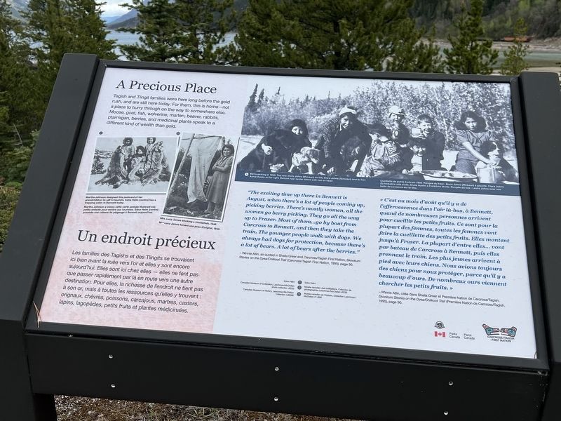
A Precious Place
⎯⎯⎯
Un endroit préciux
Photographed by Sandra Hughes Tidwell
1. A Precious Place Marker

Tagish and Tlingit families were here long before the gold rush, and are still here today. For them, this is home-not a place to hurry through on the way to somewhere else. Moose, goat, fish, wolverine, marten, beaver, rabbits, ptarmigan, berries, and medical plants speak to a different kind of wealth than gold.
- Winnie Atlin, as quoted in Sheila Greer and Carcross/Tagish First Nation, Skookum Stories on the Dyea/Chilkoot Trail (Carcross/Tagish First Nation, 1995), page 90.
- Winnie Atlin, citée dans Sheila Greer et Première Nation de Carcross/Tagish, Skookum Stories on the Dyea/Chilkoot Trail (Première Nation de Carcross/Tagish, 1995), page 90.
Erected by Parks
this page online
Topics. This historical marker is listed in these topic lists: Anthropology & Archaeology • Indigenous Peoples and Communities • Natural Resources • Settlements & Settlers. A significant historical year for this entry is 1950.
Location. 59° 50.73′ N, 134° 59.877′ W. Marker is near Bennett, British Columbia, in Stikine Region. It can be reached from Chilkoot Trail, on the right when traveling north. Touch for map. Marker is in this post office area: Bennett BC V0W 1A0, Canada. Touch for directions.

Regionally, this marker is in Northern BC. Globally, it is in North America, on the Ring of Fire, in the Pacific Rim, in the Western Hemisphere, in the Western World, and in the Anglosphere. Historically, it finds itself in what was once a British colony.
Other nearby markers. At least 7 other markers are within 16 kilometers of this marker, measured as the crow flies: Names on the land / Noms de la terre (here, next to this marker); Welcome / Bienvenue (here, next to this marker); Chilkoot Trail National Historic Site / Lieu historique national de la Piste-Chilkoot (a few steps from this marker); St. Andrew's Church / Église St. Andrew's (within shouting distance of this marker); End of Trail / Fin de la piste (about 90 meters away, measured in a direct line); Fraser (approx. 14.4 kilometers away); a different marker also named Fraser (approx. 14.7 kilometers away).
Also see . . . Who Discovered Klonkide Gold?. George and Kate Carmack, Skookum Jim, Dawson Charlie, and nephew Patsy Henderson camped at the mouth of the Klondike River during August 1896. When low on provisions, they hunted for moose whereupon they discovered gold in Rabbit Creek, later named Bonanza Creek. Carmack asserted that an Indian would not be allowed to register a claim, so he staked the discovery claim on August 1896 for himself and agreed to assign half interest to Skookum Jim. George staked No. 1 Below the discovery claim for himself, No. 2 Below for Dawson Charlie, and No. 1 Above for Skookum Jim. As a married woman, Kate did not have a claim staked in her name. (Submitted on June 18, 2024, by Sandra Hughes Tidwell of Killen, Alabama, USA.)
Credits. This page was last revised on July 28, 2026. It was originally submitted on June 18, 2024, by Sandra Hughes Tidwell of Killen, Alabama, USA. This page has been viewed 158 times since then and 28 times this year. Photo 1. submitted on June 18, 2024, by Sandra Hughes Tidwell of Killen, Alabama, USA. • Devry Becker Jones was the editor who published this page.
Editor’s want-list for this marker. A wide shot of the marker in context • Can you help?
