Ogdensburg in St. Lawrence County, New York — The American Northeast (Mid-Atlantic)
300 Years of Artifacts, Refuse and Pollution
Lighthouse Point Clean Up
Photographed by William Fischer, Jr., June 17, 2024
1. 300 Years of Artifacts, Refuse and Pollution Marker
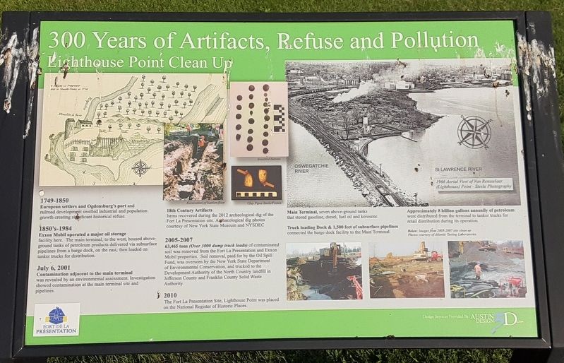
1749-1850
European settlers and Ogdensburg's port and railroad development swelled industrial and population growth creating significant historical refuse.
1850's-1984
Exxon Mobil operated a major oil storage facility here. The main terminal, to the west, housed above-ground tanks of petroleum products delivered via subsurface pipelines from a barge dock, on the east, then loaded on tanker trucks for distribution.
July 6, 2001
Contamination adjacent to the main terminal was revealed by an environmental assessment. Investigation showed contamination at the main terminal site and pipelines.
2005-2007
63,465 tons (Over 3000 dump truck loads) of contaminated soil was removed from the Fort La Presentation and Exxon Mobil properties. Soil removal, paid for by the Oil Spill Fund, was overseen by the New York State Department of Environmental Conservation, and trucked to the Development Authority of the North Country landfill in Jefferson County and Franklin County Solid Waste Authority.
2010
The Fort La Presentation Site, Lighthouse Point was placed on the National Register of Historic Places.
[Illustration captions, clockwise from top left, read]
• [Map of Fort la Presentation] 1750
18th Century Artifacts
Items
this page online
• Excavation of bastion floor
• Assorted buttons
• Clay Pipes Smile/Frown
• Main Terminal, seven above-ground tanks that stored gasoline, diesel, fuel oil and kerosene.
[Also, inset reads] 1966 Aerial View of Van Rensselaer (Lighthouse) Point
Approximately 8 billion gallons annually of petroleum were distributed from the terminal to tanker trucks for retail distribution during its operation.
Truck loading Dock & 1,500 feet of subsurface pipelines connected the barge dock facility to the Main Terminal.
• Below: Images from 2005-2007 site clean up
Erected by Fort de la Présentation.
Topics and series. This historical marker is listed in these topic lists: Colonial Era • Industry & Commerce • Parks & Recreational Areas • War of 1812. In addition, it is included in the Lighthouses series list. A significant historical date for this entry is July 6, 2001.
Location. 44° 41.659′ N, 75° 30.153′ W. Marker is in Ogdensburg, New York, in St. Lawrence County. It can be reached from Main Street. Marker is along the Abbe Picquet Walking Trail at Fort

Photographed by William Fischer, Jr., June 17, 2024
2. 300 Years of Artifacts, Refuse and Pollution Marker

Regionally, this marker is in Upstate New York and in the Adirondacks & North Country. It is also in the American Northeast and in the Mid-Atlantic. Globally, it is in North America, the Western Hemisphere, the Western World, and the Anglosphere. Historically, it finds itself in what was once the Viceroyalty of New France, the Haudenosaunee (Iroquois) Confederacy, New Netherland, and one of the original Thirteen Colonies.
Other nearby markers. At least 8 other markers are within walking distance of this marker: Abbe Picquet 1708-1781 (a few steps from this marker); Mission Fort (within shouting distance of this marker); Fort la Présentation (about 300 feet away, measured in a direct line); Fort de la Présentation - 1749-1759 (about 300 feet away); Fort Lévis - 1760 (about 300 feet away); Fort Oswegatchie 1760-1796 (about 300 feet away); The Battle of Ogdensburg (about 300 feet away); Aka Se We':Ka Tsi (Oswegatchie) (about 300 feet away). Touch for a list and map of all markers in Ogdensburg.
Credits. This page was last revised on June 20, 2024. It was originally submitted on June 19, 2024, by William Fischer, Jr. of Reynoldsburg, Ohio. This page has been viewed 200 times since then and 37 times this year. Photos: 1, 2. submitted on June 19, 2024, by William Fischer, Jr. of Reynoldsburg, Ohio.
