Hartsburg in Boone County, Missouri — The American Midwest (Upper Plains)
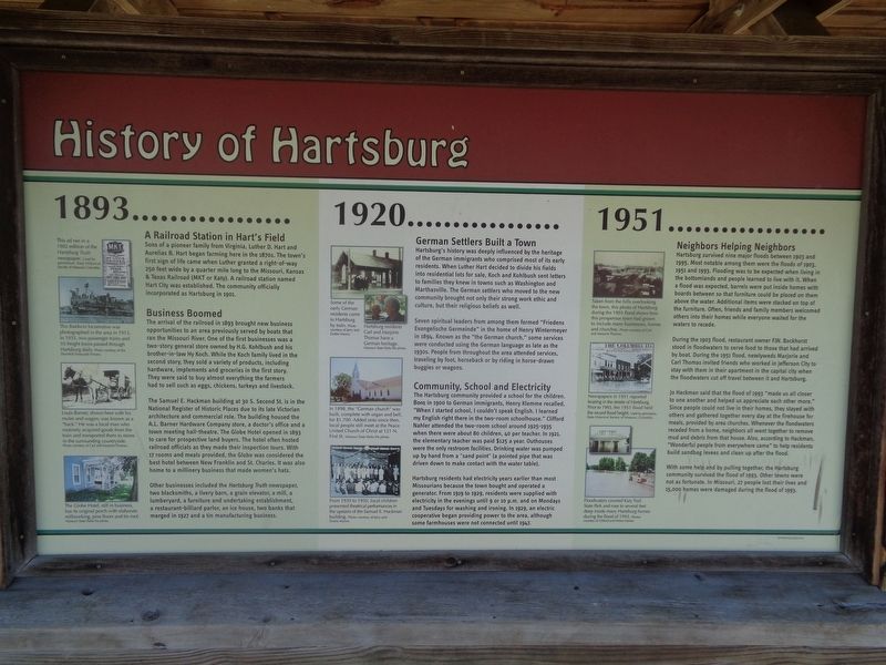
History of Hartsburg
Photographed by Jason Voigt, June 25, 2024
1. History of Hartsburg Marker
1893
A Railroad Station in Hart's Field
Sons of a pioneer family from Virginia, Luther D. Hart and Aurelias B. Hart began farming here in the 1870s. The town's first sign of life came when Luther granted a right-of-way 250 feet wide by a quarter mile long to the Missouri, Kansas & Texas Railroad (MKT or Katy). A railroad station named Hart City was established. The community officially incorporated as Hartsburg in 1901.
Business Boomed
The arrival of the railroad in 1893 brought new business opportunities to an area previously served by boats that ran the Missouri River. One of the first businesses was a two-story general store owned by H.G. Kohlbush and his brother-in-law Hy Koch. While the Koch family lived in the second story, they sold a variety of products, including hardware, implements and groceries in the first story. They were said to buy almost everything the farmers had to sell such as eggs, chickens, turkeys and livestock.
The Samuel E. Hackman building at 30 S. Second St. is in the National Register of Historic Places due to its late Victorian architecture and commercial role. The building housed
this page online
Other businesses included the Hartsburg Truth newspaper, two blacksmiths, a livery barn, a grain elevator, a mill, a lumberyard, a furniture and undertaking establishment, a restaurant-billiard parlor, an ice house, two banks that merged in 1927 and a tin manufacturing business.
(photo captions:)
·This Baldwin locomotive was photographed in the area in 1913. In 1935, two passenger trains and 10 freight trains passed through Hartsburg daily.
·Louis Barner, shown here with his mules and wagon, was known as a "hack." He was a local man who routinely acquired goods from the train and transported them to stores in the surrounding countryside.
·The Globe Hotel, still in business, has its original porch with elaborate

Photographed by Jason Voigt, June 25, 2024
2. History of Hartsburg Marker
Marker is the middle panel
1920
German Settlers Built a Town
Hartsburg's history was deeply influenced by the heritage of the German immigrants who comprised most of its early residents. When Luther Hart decided to divide his fields into residential lots for sale, Koch and Kohlbush sent letters to families they knew in towns such as Washington and Marthasville. The German settlers who moved to the new community bought not only their strong work ethic and culture, but their religious beliefs as well.
Seven spiritual leaders from among them formed "Friedens Evangelische Germeine" in the home of Henry Wintermeyer in 194. Known as "the German church," some services were conducted using the German language as late as the 1930s. People from throughout the area attended services, traveling by foot, horseback or by riding in horse-drawn buggies or wagons.
Community, School and Electricity
The Hartsburg community provided a school for the children. Born in 1900 to German immigrants, Henry Klemme recalled, "When I started school, I couldn't speak English. I learned my English right there in the two-room schoolhouse."

Photographed by Jason Voigt, June 25, 2024
3. History of Hartsburg Marker
Marker is located at the Katy Trail-Hartsville Trailhead (side facing the trail)
Hartsburg residents had electricity years earlier than most Missourians because the town bought and operated a generator. From 1919 to 1929, residents were supplied with electricity in the evenings until 9 or 10 p.m. and on Mondays and Tuesdays for washing and ironing. In 1929, an electric cooperative began providing power to the area, although some farmhouses were not connected until 1947.
(photo captions:)
·Some of the early German residents came to Hartsburg by train
·Hartsburg residents Carl and Marjorie Thomas have a German heritage.
·In 1898, the "German church" was built, complete with organ and bell, for $1,700. Added onto since then, local people still meet at the Peace United Church of Christ at 121 N. First St.
·From 1930 to 1950, local children presented theatrical performances in the upstairs of the Samuel E. Hackman building.
1951
Neighbors helping Neighbors
Hartsburg survived nine major floods between 1903 and 1995. Most notable among them were the floods of 1903, 1951 and 1993. Flooding was to be expected when living in the bottomlands and people learned to live with it. When a flood was expected, barrels were put inside homes with boards between that so furniture could be placed on them above the water. Additional items were stacked on top of the furniture. Often, friends and family members welcomed others into their homes while everyone waited for the waters to recede.
During the 1903 flood, restaurant owner F.W. Bockhorst stood in floodwaters to serve food to those that had arrived by boat. During the 1951 flood, newlyweds Marjorie and Carl Thomas invited friends who worked in Jefferson City to stay with them in their apartment in the capital city when the floodwaters cut off travel between it and Hartsburg.
Jo Hackman said that the flood of 1993 "made us all closer to one another and helped us appreciate each other more." Since people could not live in their homes, they stayed with others and gathered together every day at the firehouse for meals, provided by area churches. Whenever the floodwaters receded from a home, neighbors all went together to remove mud and debris from that house. Also, according to Hackman, "Wonderful people from everywhere came" to help residents build sandbag levees and clean up after the flood.
With some help and by pulling together, the Hartsburg community survived the flood of 1993. Other towns were not as fortunate. In Missouri, 27 people lost their lives and 15,000 homes were damaged during the flood of 1993.
(photo captions:)
·Taken from the hills overlooking the town, this photo of Hartsburg during the 1903 flood shows how this prosperous town had grown to include many businesses, homes and churches.
·Newspapers in 1951 reported boating in the streets of Hartsburg. Prior to 1993, the 1951 flood held the record flood height.
·Floodwaters covered Katy Trail State Park and rose to several feet deep inside many Hartsburg homes during the flood of 1993.
Erected by Missouri State Parks.
Topics and series. This historical marker is listed in these topic lists: Disasters • Immigration • Roads & Vehicles • Settlements & Settlers. In addition, it is included in the Katy Trail State Park series list. A significant historical year for this entry is 1893.
Location. 38° 41.662′ N, 92° 18.595′ W. Marker is in Hartsburg, Missouri, in Boone County. It is on South 2nd Street, on the right when traveling east. Marker is located at the Katy Trail-Hartsburg Trailhead. Touch for map. Marker is at or near this postal address: 95 S 2nd St, Hartsburg MO 65039, United States of America. Touch for directions.

Regionally, this marker is in Little Dixie and in the Missouri River Corridor. It is also in the American Midwest, in the Lewis & Clark Corridor, and in the Corn Belt. Globally, it is in North America, the Western Hemisphere, the Western World, and the Anglosphere. Historically, it finds itself in what was once the territory of the Mississippian Culture, the Louisiana Purchase, and the Antebellum South.
Other nearby markers. At least 8 other markers are within 10 miles of this marker, measured as the crow flies: Hartsburg Bottoms and Bluffs (here, next to this marker); Hartsburg to N. Jefferson (here, next to this marker); Fertile Fields and Flooding (approx. 7.2 miles away); The Lewis and Clark Expedition Across Missouri (approx. 7.2 miles away); The Great Flood of 1993 (approx. 10 miles away); Katy Trail State Park (approx. 10 miles away); Bicentennial Monument (approx. 10 miles away); Lewis and Clark in Missouri (approx. 10 miles away). Touch for a list and map of all markers in Hartsburg.
Also see . . . Katy Trail State Park (Missouri State Parks). (Submitted on July 8, 2024, by Jason Voigt of Glen Carbon, Illinois.)
Additional commentary.
1. Great Flood of 1993
I recently wrote a book titled 1993 about the flood in Hartsburg and the efforts that were made to recover. It includes information from my wife's files (Nancy Grant, Flood Relief Coordinator) and firsthand information as I was the mayor during that time. It includes information on the people from 32 states that came to help us such as Sherman Dick from Martinsburg, PA and Gordie Ferguson from Bloomer, Wi. As time passes so do those of us who were involved.
Alas some people remember, and some forget; others stretch the facts. We survived by hard work on the part of many people. The Salvation Army played a huge part in our recovery and will always be remembered. The town of Versailles, Mo. under Anita Comer were wonderful. The FIREHOUSE CAFE was our center where Nancy and helpers fed as many as 300 per day thanks to generous donations of food. Sadly, most of our "heroes" from 1993 have died but they are not forgotten by those of us who survived. Note To Editor only visible by Contributor and editor
— Submitted August 19, 2024, by Michael Rodemeyer of Hartsburg, Missouri.
Credits. This page was last revised on September 5, 2024. It was originally submitted on July 8, 2024, by Jason Voigt of Glen Carbon, Illinois. This page has been viewed 1,311 times since then and 223 times this year. Photos: 1, 2, 3. submitted on July 8, 2024, by Jason Voigt of Glen Carbon, Illinois.
